Definitionپێناسە
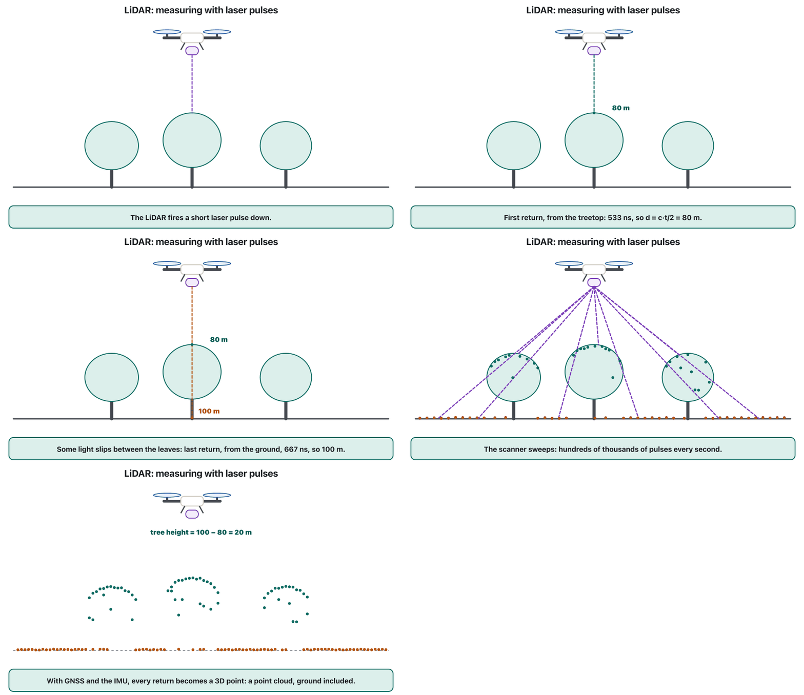
A that sends thousands of pulses and times how long each takes to bounce back, so it knows the distance to every point: . From a drone it builds a 3D and can even see the ground between trees.
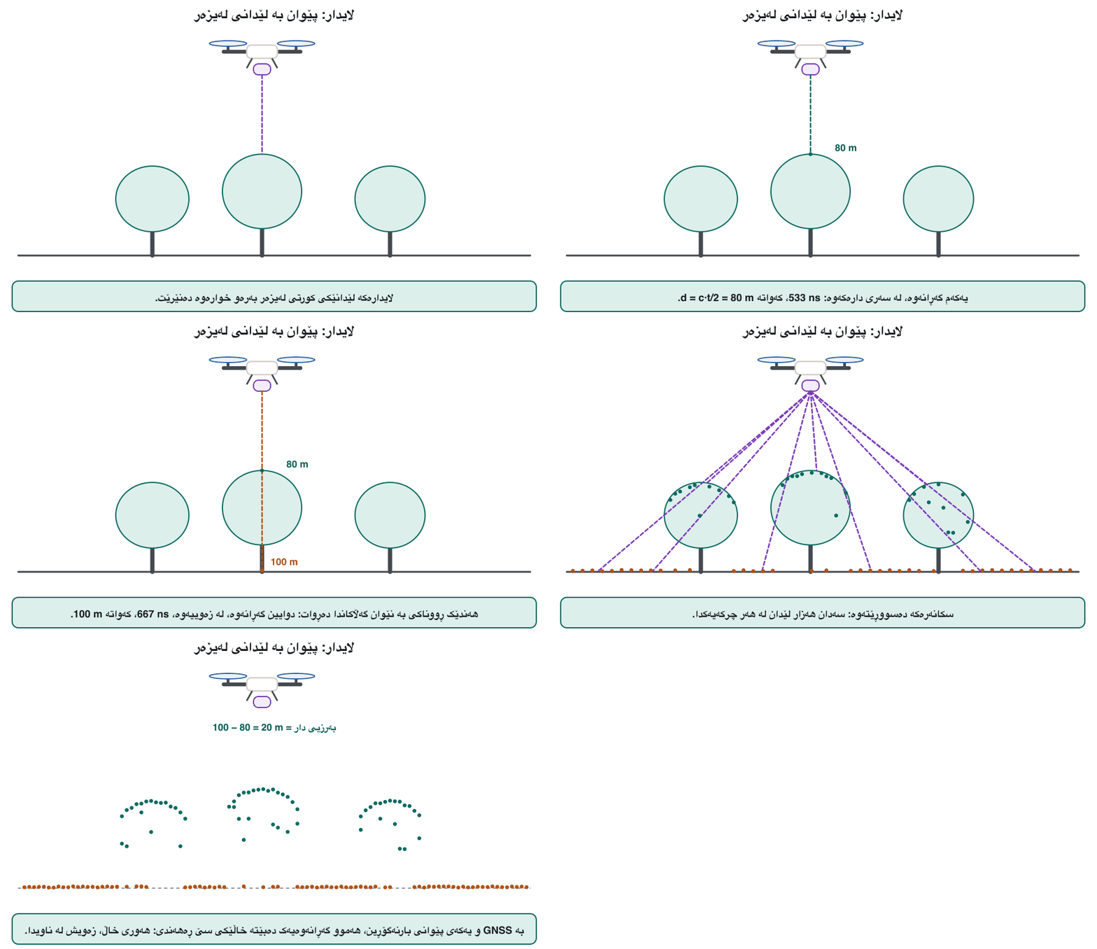
کە هەزاران لێدانی دەنێرێت و دەپێوێت هەریەکەیان چەندی پێ دەچێت تا دەگەڕێتەوە، بۆیە دووری هەموو خاڵێک دەزانێت: . لەسەر سێ ڕەهەندی دروست دەکات و تەنانەت زەویی نێوان دارەکانیش دەبینێت.
Picturesوێنەکان
Exampleنموونە
Over a forest, LiDAR maps the ground under the trees, while photogrammetry only sees the treetops.
بەسەر دارستانێکدا، نەخشەی زەویی ژێر دارەکان دەکێشێت، بەڵام تەنیا سەری دارەکان دەبینێت.
Other Kurdish renderings in useوەرگێڕانە کوردییەکانی تر
لایدارەکە، لایدارەکان، لایدارێک، لایداری
Note on the Kurdish termتێبینی لەبارەی زاراوە کوردییەکە
Proposed loan, built like the registry's «ڕادار» and «لەیزەر» (Arabic «ليدار», Persian «لایدار»). How lidar works: NOAA (drn.x12). IoT and other courses may reuse this entry.
Related termsزاراوە پەیوەندیدارەکان
Learn more inزیاتر فێربە لە
- Payloads and Mapping: Cameras, Thermal, LiDAR and Photogrammetryباری درۆن و نەخشەکێشان: کامێرا، گەرمی، لایدار و فۆتۆگرامێتری
- Autonomy, Swarms, Air Taxis and the Future of Dronesسەربەخۆیی، ڕەوەکانی درۆن، تەکسییە ئاسمانییەکان و داهاتووی درۆنەکان
- The Flight Controller: Sensors, Control Loops and Autopilotsکۆنترۆڵکەری فڕین: هەستەوەرەکان، خولەکانی کۆنترۆڵ و فڕۆکەوانی خۆکار
- Cloud, Fog and Edge Computingهەورەژمێرکاری، ژمێرکاریی تەم و ژمێرکاریی لێوار
- Machine Learning Basics (Supplementary)بنەماکانی فێربوونی ئامێر (زیادە)
- Sensors: How Things Feel the Worldهەستەوەرەکان: شتەکان چۆن هەست بە جیهان دەکەن
- Cellular IoT: 4G, 5G, LTE-M and NB-IoTIoTـی خانەیی: 4G، 5G، LTE-M و NB-IoT