Chapterبەش 2 · Lectureوانە 2.3
The Flight Controller: Sensors, Control Loops and Autopilotsکۆنترۆڵکەری فڕین: هەستەوەرەکان، خولەکانی کۆنترۆڵ و فڕۆکەوانی خۆکار
The flight controller is the drone's brain: a small computer that reads the gyroscope, accelerometer, compass, barometer and other sensors, fuses them into one best guess, and corrects every motor hundreds of times a second with control loops such as PID. Also: flight modes, the open-source autopilots PX4 and ArduPilot, ground stations and pre-arm checks.
مێشکی : کۆمپیوتەرێکی بچووکە کە ، ، ، و تر دەخوێنێتەوە، دەیانکاتە یەک باشترین مەزەندە و بە وەک PID چەند سەد جار لە چرکەیەکدا خێرایی هەموو ڕاست دەکاتەوە. هەروەها: ، PX4 و ArduPilot کە دوو ، و پشکنینەکانی پێش .
What you will learnچی فێر دەبیت
- Explain what a flight controller is and what it does many times every second.
- Name a drone's sensors, say what each one measures and how it can be fooled.
- Explain sensor fusion and the control loop: measure, compare, correct.
- Describe what P, I and D do, and recognise a controller tuned too weak, too strong or just right.
- Choose a suitable flight mode, and explain pre-arm checks and why they must never be switched off.
- ڕوونی بکەیتەوە چییە و لە هەر چرکەیەکدا چەندین جار چی دەکات.
- ناو ببەیت و بڵێیت هەریەکەیان چی دەپێوێت و چۆن هەڵدەخەڵەتێت.
- و ڕوون بکەیتەوە: پێوان، بەراوردکردن، ڕاستکردنەوە.
- ڕوونی بکەیتەوە P، I و D چی دەکەن و بناسیتەوە کە زۆر لاواز، زۆر بەهێز یان گونجاو ڕێکخراوە.
- هەڵبژێریت و پشکنینەکانی پێش ڕوون بکەیتەوە و بڵێیت بۆچی نابێت هەرگیز بکوژێنرێنەوە.
The drone's brainمێشکی درۆن
Inside every drone sits a small computer board: the flight controller. People call it the drone's "brain", because it processes inputs and controls the flight. The inputs are the readings of its sensors and the pilot's commands. What it controls is how the drone is tilted, how high it is, where it is and, in the end, how fast each motor spins.
لە ناو هەموو بۆردێکی کۆمپیوتەریی بچووک هەیە: . پێی دەڵێن «مێشک»ـی ، چونکە چارەسەر دەکات و فڕینەکە کۆنترۆڵ دەکات. خوێندنەوەی و فڕۆکەوانن. ئەوەی کۆنترۆڵی دەکات ئەمەیە: چەند لار بووەتەوە، چەند بەرزە، لە کوێیە و لە کۆتاییدا هەر بە چ خێراییەک دەسووڕێت.
The heart of the board is a microcontroller — a whole small computer on one chip (Microcontrollers) — that runs autopilot software, also called the flight stack, on a small real-time operating system (RTOS). PX4 and ArduPilot are the two best-known open-source autopilots. The autopilot repeats one job hundreds of times a second: read the sensors, work out the drone's state and send a new speed to every ESC (Signals from the flight controller).
دڵی بۆردەکە — کۆمپیوتەرێکی بچووکی تەواو لەسەر یەک (مایکرۆکۆنترۆڵەرەکان) — کە (flight stack) لەسەر بچووک کار پێ دەکات (RTOS). PX4 و ArduPilot ناسراوترین دوو . یەک کار چەند سەد جار لە چرکەیەکدا دووپاتە دەکاتەوە: دەخوێنێتەوە، دۆخی دەدۆزێتەوە و خێراییەکی نوێ بۆ هەر دەنێرێت (سیگناڵەکان لە کۆنترۆڵکەری فڕینەوە).
The drone's brainمێشکی درۆن
Real boards: spare sensors and protectionبۆردی ڕاستەقینە: هەستەوەری یەدەگ و پاراستن
A real flight controller is small. The Pixhawk 6X, a board built to the open Pixhawk standard for PX4, has a 480 MHz processor, 2 MB of flash memory and 1 MB of RAM, and its core module weighs 23 g. It also shows redundancy: three IMUs and two barometers on separate wires and power, so one failed sensor does not bring the drone down. Besides spare sensors, the firmware guards the processor itself with a watchdog that restarts it if its main loop hangs: see Lab: The Watchdog Timer.
ڕاستەقینە بچووکە. Pixhawk 6X، بۆردێک کە بەپێی Pixhawk بۆ PX4 دروست کراوە، پرۆسێسەرێکی 480 MHz، 2 MB و 1 MB RAMـی هەیە و مۆدیولە سەرەکییەکەی 23 گرامە. نیشان دەدات: سێ و دوو لەسەر وایەر و کارەبای جیا، بۆ ئەوەی تێکچوونی یەک نەخات. جگە لە یەدەگ، خودی بە دەپارێزێت کە ئەگەر گیر بخوات دەستی پێ دەکاتەوە: بڕوانە تاقیگە: تایمەری پاسەوان.
The sensors also need protection. Motor vibration shakes them, so the IMUs sit on a small shock-absorbing mount, and tiny heating resistors keep them at a steady temperature, because MEMS sensors change their readings slightly when they warm up or cool down. Camera drones from big makers hide all this inside their shell, but the job is the same.
پاراستنیشیان پێویستە. لەرینەوەی دەیانهەژێنێت، بۆیە لەسەر پایەیەکی بچووکی دژەلەرین دادەنرێت و بە گەرم ڕادەگیرێت تا پلەی گەرمیی جێگیر بمێنێت، چونکە MEMS کاتێک گەرم یان سارد دەبنەوە خوێندنەوەکانیان کەمێک دەگۆڕێت. کامێرادار کە کۆمپانیا گەورەکان دروستیان دەکەن هەموو ئەمانە لە ناو لەشیاندا دەشارنەوە، بەڵام کارەکە هەمان کارە.
Sense, decide, act — hundreds of times a secondهەستکردن، بڕیاردان، کارکردن — چەند سەد جار لە چرکەیەکدا
A flight controller works like every robot: it senses, decides and acts, in a loop that never stops (Robots: sense, decide, act). In the language of artificial intelligence, a drone is an agent: its sensors are the gyroscope, the compass, GNSS and the rest, and its actuators are the motors, which the ESCs drive (Sensors, Actuators).
وەک هەموو کار دەکات: هەست دەکات، بڕیار دەدات و کار دەکات، لە خولێکدا کە هەرگیز ناوەستێت (ڕۆبۆتەکان: هەستکردن، بڕیاردان، کارکردن). بە زمانی ، : بریتین لە ، ، GNSS و ئەوانی تر و بریتین لە ، کە دەیانسووڕێنن (هەستەوەرەکان، جووڵێنەرەکان).
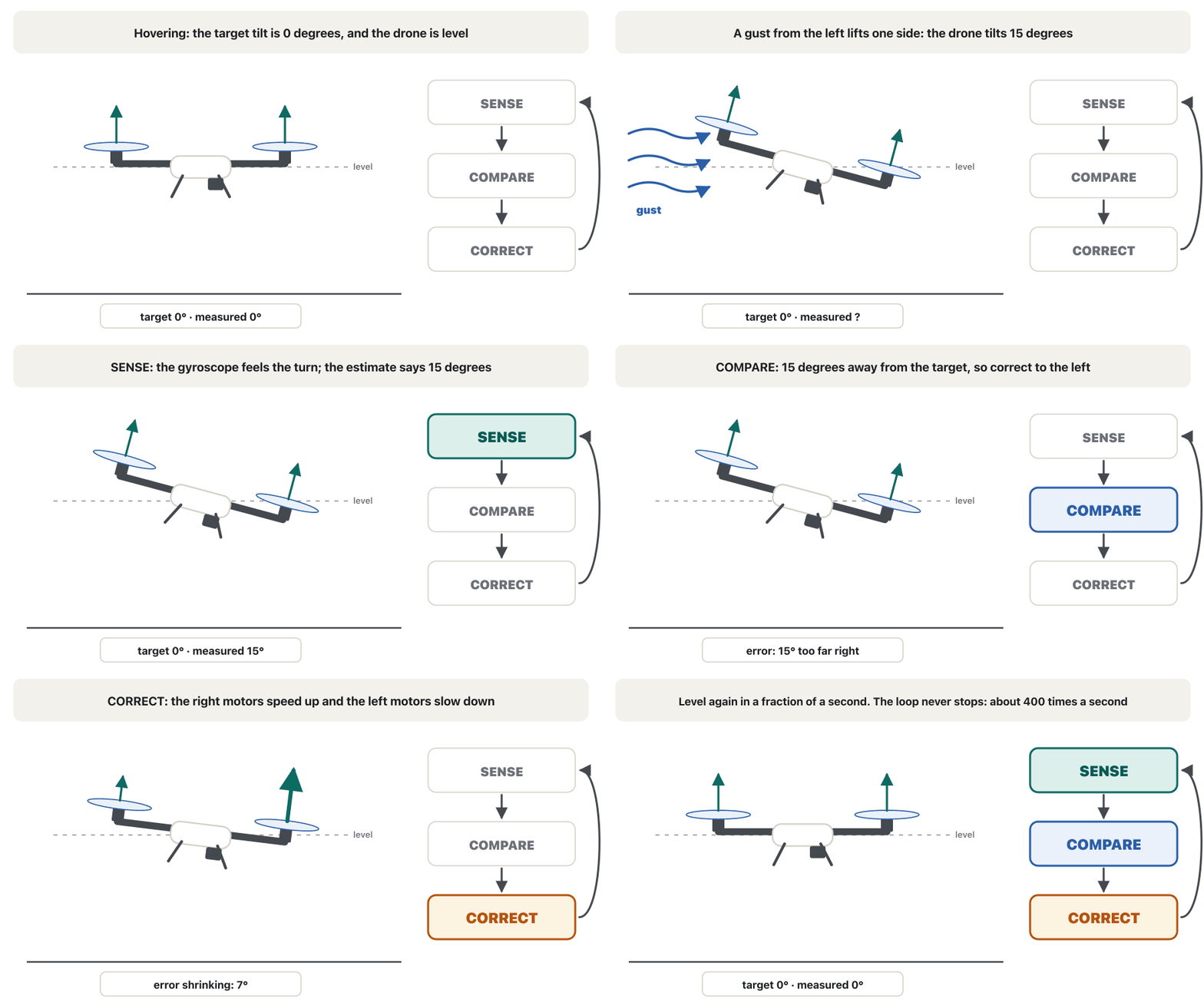
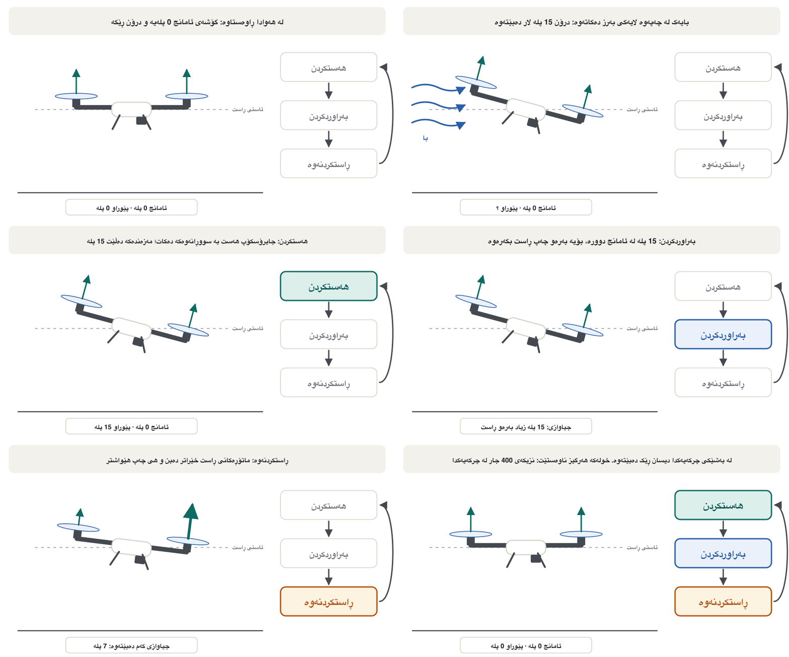
Each time round, the sensors measure; the autopilot works out where the drone is and how it is tilted, compares that with where it should be, and decides on a correction; the ESCs change the motor speeds. The drone moves, the sensors see the change and the loop starts again. The pilot's sticks — or a planned mission — only set the target.
لە هەر جارێکدا دەپێون؛ دەدۆزێتەوە لە کوێیە و چەند لار بووەتەوە، ئەوە لەگەڵ ئەو شوێنەی کە دەبێت تێیدا بێت بەراورد دەکات و بڕیاری ڕاستکردنەوەیەک دەدات؛ خێراتر یان هێواشتر دەکەن. دەجووڵێت، گۆڕانەکە دەبینن و دیسان دەست پێ دەکاتەوە. فڕۆکەوان — یان ئەرکێکی پلاندانراو — تەنیا ئامانجەکە دیاری دەکەن.
The drone's sensesهەستەکانی درۆن
A drone must always know three things: how it is tilted, how high it is and where it is. No single sensor can tell all of that, so it carries several. PX4 needs at least four: a gyroscope, an accelerometer, a magnetometer (compass) and a barometer. It adds GNSS for its automatic modes, highly recommends a rangefinder and can use optical flow.
هەمیشە دەبێت سێ شت بزانێت: چەند لار بووەتەوە، چەند بەرزە و لە کوێیە. هیچ بە تەنیا ناتوانێت هەموو ئەمانە بڵێت، بۆیە چەند دانەیەک هەڵدەگرێت. PX4 لانیکەم چواری پێویستە: ، ، (وەک قیبلەنما) و . بۆ دۆخە خۆکارەکانی GNSSـی پێویستە، بە توندی پێشنیاری دەکات و دەتوانێت بەکار بهێنێت.
| Sensor | Measuresچی دەپێوێت | The drone uses it for بۆ چی بەکاری دەهێنێت |
|---|---|---|
| Gyroscope (in the IMU) (لە ناو ) | how fast it turnsبە چ خێراییەک دەسووڕێتەوە | staying level, in the fastest loopڕێک مانەوە، لە خێراترین خولدا |
| Accelerometer (in the IMU) (لە ناو ) | speeding up and the pull of gravityخێرابوون و ڕاکێشانی | knowing which way is downزانینی ئەوەی خوارەوە کامەیە |
| Magnetometer | the Earth's magnetic fieldبواری موگناتیسیی زەوی | which way the nose pointsلووتی ڕووی لە کام لایە |
| Barometer | air pressure | height |
| GNSS receiverوەرگری GNSS | satellite signals مانگی دەستکرد | position and speed (next lesson)شوێن و خێرایی (وانەی داهاتوو) |
| Rangefinder, optical flow، | distance to the ground; how the ground slides pastدووری تا زەوی؛ زەوی چۆن بەردەمی دەخلیسکێت | landing; holding still without GNSSنیشتنەوە؛ ڕاوەستان بەبێ GNSS |
| Obstacle sensors, cameras بەربەست، کامێرا | what is around the droneچی لە دەوری | avoiding crashes; pictures (payloads)خۆپاراستن لە بەرکەوتن؛ وێنە (باری درۆن) |
The IMU: gyroscope and accelerometerیەکەی پێوانی بارنەگۆڕین: جایرۆسکۆپ و ئەکسێلەرۆمیتەر
The gyroscope and the accelerometer sit together in one tiny chip, the IMU (inertial measurement unit). They are MEMS sensors — microscopic moving structures made in silicon — the same kind of chip that turns your phone's screen (The sensors in your phone); IoT labs use one on a small board (the MPU-6050). Each measures three numbers, one for each direction (Three axes), hundreds or thousands of times a second.
و پێکەوە لە یەک زۆر بچووکدان: (inertial measurement unit). ئەمانە جۆری MEMSـن — پێکهاتەی جووڵاوی زۆر ورد کە لە سیلیکۆن دروست کراون — هەمان جۆری ئەو کە شاشەی مۆبایلەکەت دەسووڕێنێت (هەستەوەرەکانی ناو مۆبایلەکەت)؛ تاقیگەکانی IoT یەکێکی لەسەر بۆردێکی بچووک بەکار دەهێنن (MPU-6050). هەریەکەیان سێ ژمارە دەپێوێت، یەکێک بۆ هەر ئاراستەیەک (سێ تەوەرەکە)، سەدان یان هەزاران جار لە چرکەیەکدا.
The gyroscope measures how fast the drone turns, in degrees per second. Adding up these turns gives the tilt angle, but tiny errors add up too: a gyroscope that reads just 0.1 °/s too much is 6° wrong after one minute. This slow creep is called drift. The accelerometer feels gravity, so when the drone is still it knows which way is down — but every bump, turn and motor vibration shakes its reading. The gyroscope is smooth but drifts; the accelerometer does not drift but is noisy. Before take-off the flight controller measures the gyroscope's small constant error while the drone stands still and subtracts it — a one-point calibration, as in Drift and calibration — but a little error always remains.
دەپێوێت بە چ خێراییەک دەسووڕێتەوە، بە پلە لە چرکەیەکدا. کۆکردنەوەی ئەم سووڕانەوانە لاربوونەوە دەدات، بەڵام هەڵە وردەکانیش کۆ دەبنەوە: کە تەنیا 0.1 پلە لە چرکەیەکدا زیاتر بخوێنێتەوە، دوای یەک خولەک 6 پلە هەڵەیە. بەم خزینە هێواشە دەوترێت لادان (drift). هەست بە دەکات، بۆیە کاتێک وەستاوە دەزانێت خوارەوە کامەیە — بەڵام هەموو تەکان، سووڕانەوە و لەرینەوەیەکی خوێندنەوەکەی دەهەژێنێت. ڕێکە بەڵام لادەدات؛ لانادات بەڵام زۆرە. پێش هەستان، هەڵە جێگیرە بچووکەکەی دەپێوێت کاتێک وەستاوە و لە خوێندنەوەکان کەمی دەکاتەوە — بە یەک خاڵ، وەک لە لادانی هەستەوەر و ڕێکخستنی پێواندا — بەڵام هەمیشە هەڵەیەکی کەم دەمێنێتەوە.
Compass and barometerماگنێتۆمیتەر و بارۆمەتر
The magnetometer is an electronic compass: it measures the Earth's magnetic field, so the drone knows which way its nose points, even while it hovers. The Earth's field is weak, so motors, power cables, steel roofs, concrete full of steel bars and even a phone in your pocket can bend it. That is why the compass usually sits in the GNSS module on a mast, away from the power wires. For the same reason you calibrate it in an open space, away from cars and metal.
قیبلەنمایەکی ئەلیکترۆنییە: بواری موگناتیسیی زەوی دەپێوێت، بۆیە دەزانێت لووتی ڕووی لە کام لایە، تەنانەت کاتێک لە هەوادا ڕاوەستاوە. بواری زەوی لاوازە، بۆیە ، کێبڵی کارەبا، سەربانی ئاسن، کۆنکریتی پڕ لە شیشی ئاسن و تەنانەت مۆبایلێک لە گیرفانتدا دەتوانن لای بدەن. لەبەر ئەوە زۆرجار لە ناو یەکەی GNSS لەسەر ستوونێکە، دوور لە وایەرەکانی کارەبا. هەر لەبەر ئەمەش لە شوێنێکی کراوە، دوور لە ئۆتۆمبێل و ئاسن، ڕێکی دەخەیت (calibrate).
The barometer measures air pressure. Near the ground the pressure falls about 1 hPa for every 8–9 m you climb, so the autopilot turns pressure into altitude. But the weather changes the pressure too: a change of 1 hPa, which can happen within a few hours, looks like 8–9 m of climbing. Wind and the propellers' own downwash also disturb it, so builders shield it with a little open-cell foam.
دەپێوێت. نزیک زەوی، بۆ هەر 8 تا 9 مەتر بەرزبوونەوە پەستان نزیکەی 1 hPa کەم دەبێتەوە، بۆیە پەستان دەکاتە . بەڵام کەشوهەواش پەستان دەگۆڕێت: گۆڕانی 1 hPa، کە دەکرێت لە ماوەی چەند کاتژمێرێکدا ڕووبدات، وەک 8 تا 9 مەتر بەرزبوونەوە دەردەکەوێت. با و هەوای خۆیشی تێکی دەدەن، بۆیە دروستکەران پارچەیەکی بچووکی ئیسفەنجی کونکون بەسەریدا دادەنێن.
Compass and barometerماگنێتۆمیتەر و بارۆمەتر
Looking down: rangefinder and optical flowسەیرکردنی خوارەوە: هەستەوەری دووری و تەوژمی وێنە
Close to the ground, a few metres of barometer error matter a lot. A downward rangefinder measures the distance to the ground directly; it can be a lidar, an infrared sensor, an ultrasonic sensor or a small radar. Autopilots use it for the last metres of landing, for following the shape of the ground and for precision landing; above its maximum range they switch back to the barometer.
لە نزیک زەوی، چەند مەترێک هەڵەی زۆر گرنگە. ڕوو لە خوارەوە ڕاستەوخۆ دووری تا زەوی دەپێوێت؛ دەکرێت ، ، یان بچووک بێت. بۆ دوا مەترەکانی نیشتنەوە، بۆ فڕین بەدوای شێوەی زەویدا و بۆ نیشتنەوەی ورد بەکاری دەهێنێت؛ لە سەرووی زۆرترین مەودای خۆیەوە دەگەڕێتەوە سەر .
An optical flow camera looks straight down and watches how the picture of the ground slides past. If the ground slides backwards, the drone is moving forwards. Together with a rangefinder, which gives the scale, it can hold a drone still indoors or under a bridge, where GNSS does not work.
کامێرای ڕاست سەیری خوارەوە دەکات و دەبینێت وێنەی زەوی چۆن بەردەمی دەخلیسکێت. ئەگەر زەوی بەرەو دواوە بخلیسکێت، بەرەو پێشەوە دەجووڵێت. لەگەڵ ، کە پێوانەکە دەدات، دەتوانێت لە ناو باڵەخانە یان لە ژێر پردێکدا ڕابگرێت، لەو شوێنانەی GNSS کار ناکات.
Obstacle sensorsهەستەوەرەکانی بەربەست
To avoid hitting walls, trees and wires, many drones carry obstacle-avoidance sensors that look forwards, sideways, up or all around. Each kind sees the world differently:
بۆ ئەوەی بەر دیوار، دار و وایەر نەکەون، زۆرێک لە هەڵدەگرن کە ڕوو لە پێشەوە، لاکان، سەرەوە یان هەموو لایەک دەڕوانن. هەر جۆرێکیان بە شێوەیەکی جیاواز جیهان دەبینێت:
| Sensor | How it worksچۆن کار دەکات | Good atلە چیدا باشە | Weak atلە چیدا لاوازە |
|---|---|---|---|
| Ultrasonic | times the echo of a sound pulseکاتی دەنگدانەوەی تڕپەیەکی دەنگ دەپێوێت | cheap; very close objectsهەرزان؛ شتی زۆر نزیک | only a few metres; soft surfaces, windتەنیا چەند مەترێک؛ ڕووی نەرم، با |
| Time-of-flight beamتیشکی کاتی فڕین (ToF) | times a pulse of infrared or laser lightکاتی تڕپەیەکی ڕووناکیی یان دەپێوێت | small and fastبچووک و خێرا | one narrow beam; strong sunlightیەک تیشکی تەسک؛ خۆری بەهێز |
| Stereo camerasدوو کامێرای هاوجووت | two cameras judge depth like two eyesدوو کامێرا وەک دوو چاو قووڵایی مەزەندە دەکەن | wide view, colourبینینی فراوان، ڕەنگ | darkness, plain walls, glareتاریکی، دیواری بێنەخش، تیشکدانەوە |
| Lidar | sweeps a laser, thousands of points دەگێڕێت، هەزاران خاڵ | exact distances all aroundدووریی ورد بە هەموو لایەکدا | weight, price, glass, rainکێش، نرخ، شووشە، باران |
| Radar | radio waves and their echoes و دەنگدانەوەیان | dust, fog, smoke, darknessتۆز، تەم، دووکەڵ، تاریکی | less detailوردەکاریی کەمتر |
Sensing is only the first step. Turning these readings into a safe new path is part of autonomy, taught in Obstacle avoidance.
هەستکردن تەنیا یەکەم هەنگاوە. گۆڕینی ئەم خوێندنەوانە بۆ ڕێگایەکی نوێی سەلامەت بەشێکە لە ، کە لە خۆلادان لە بەربەست دەیخوێنیت.
Sensor fusion: one best guessیەکخستنی هەستەوەرەکان: یەک باشترین مەزەندە
Every sensor has a weakness: the gyroscope drifts, the accelerometer is noisy, the compass can be fooled, the barometer follows the weather, and GNSS is slow and sometimes jumps. Sensor fusion mixes them all into one best guess of the drone's tilt, heading, speed and position. The same idea is explained in How AI sees: sensor fusion; a flight controller does it all the time.
هەموو لاوازییەکی هەیە: لادەدات، زۆرە، هەڵدەخەڵەتێت، بەدوای کەشوهەوادا دەڕوات و GNSS هێواشە و هەندێک جار بازدەدات. هەموویان تێکەڵ دەکات و یەک باشترین مەزەندە دەدات بۆ لاربوونەوە، ئاراستە، خێرایی و شوێنی . هەمان بیرۆکە لە ژیریی دەستکرد چۆن دەبینێت: یەکخستنی هەستەوەرەکان ڕوون کراوەتەوە؛ هەمیشە ئەمە دەکات.
Sensor fusion: one best guessیەکخستنی هەستەوەرەکان: یەک باشترین مەزەندە
How the estimator predicts and correctsمەزەندەکەر چۆن پێشبینی دەکات و ڕاستی دەکاتەوە
PX4 and ArduPilot fuse their sensors with an EKF (Extended Kalman Filter), an algorithm for making estimates. It predicts with the IMU — from the last state and the measured turns and accelerations, where should the drone be now? — and then corrects the prediction with GNSS, the compass, the barometer and the rangefinder. A measurement that disagrees too much with the prediction is rejected, so one bad sensor cannot drag the answer far away.
PX4 و ArduPilot خۆیان بە EKF (Extended Kalman Filter) یەک دەخەن، کە بۆ مەزەندەکردن. بە پێشبینی دەکات — لە دۆخی پێشوو و ئەو سووڕانەوە و پێوراون، ئێستا دەبێت لە کوێ بێت؟ — پاشان پێشبینییەکە بە GNSS، ، و ڕاست دەکاتەوە. پێوانێک کە زۆر لەگەڵ پێشبینییەکە جیاواز بێت ڕەت دەکرێتەوە، بۆیە یەک خراپ ناتوانێت وەڵامەکە زۆر دوور بخات.
Imagine walking home through the old bazaar after the power goes off. You count your steps and feel every turn (the IMU). Now and then you glance at the compass on your phone (the magnetometer). When you pass the clock tower, you know exactly where you are (a GNSS fix). Steps alone slowly lead you astray; the landmark alone comes too rarely. Together they keep you on track.
وای دابنێ دوای بڕانی کارەبا بە ناو بازاڕی کۆندا بەرەو ماڵ دەڕۆیت. هەنگاوەکانت دەژمێریت و هەست بە هەموو سووڕانەوەیەک دەکەیت (). جار جار سەیری قیبلەنمای مۆبایلەکەت دەکەیت (). کاتێک بە لای بورجی کاتژمێرەکەدا تێدەپەڕیت، بە وردی دەزانیت لە کوێیت (شوێنی GNSS). هەنگاو بە تەنیا وردە وردە ڕێگات لێ تێک دەدات؛ نیشانەکەش بە تەنیا زۆر بە کەمی دێت. پێکەوە لەسەر ڕێگا ڕاتدەگرن.
Where the analogy stops workingسنووری ئەم نموونەیە
A real EKF does this with numbers hundreds of times a second, and it also estimates how much to trust each sensor at every moment.
EKFـی ڕاستەقینە ئەمە بە ژمارە چەند سەد جار لە چرکەیەکدا دەکات، هەروەها لە هەر ساتێکدا مەزەندە دەکات چەند متمانە بە هەر بکات.
The control loopخولی کۆنترۆڵ
Knowing the state is half the job; the other half is fixing it. The flight controller compares what it measures with what it wants — the set point, for example "level, 0° tilt" — and corrects the difference. Then it measures again. This control loop (or feedback loop) never stops: in ArduPilot's Copter the main loop runs 400 times a second, so a correction goes out every 2.5 milliseconds. Embedded systems everywhere use the same idea (Closed-loop control).
زانینی دۆخەکە نیوەی کارەکەیە؛ نیوەکەی تر چاککردنەوەیەتی. ئەوەی دەیپێوێت لەگەڵ ئەوەی دەیەوێت بەراورد دەکات — ، بۆ نموونە «ڕێک، 0 پلە لاربوونەوە» — و جیاوازییەکە ڕاست دەکاتەوە. پاشان دیسان دەپێوێت. ئەم هەرگیز ناوەستێت: لە Copterـی ArduPilotـدا خولە سەرەکییەکە 400 جار لە چرکەیەکدا کار دەکات، واتە هەر 2.5 میلیچرکە جارێک ڕاستکردنەوەیەک دەنێردرێت. لە هەموو شوێنێک هەمان بیرۆکە بەکار دەهێنن (خولی کۆنترۆڵ لە سیستەمە چەسپێنراوەکاندا).
ArduCopter 4.7 and later can even run the innermost loop in its own fast thread, close to the rate at which the gyroscopes deliver data — up to 4,000 times a second on suitable boards. That is why a gust that tilts a drone is usually corrected before you can see it.
ArduCopter 4.7 و وەشانەکانی دواتر دەتوانن ناوەکیترین خول لە ڕێڕەوێکی خێرای تایبەتدا کار پێ بکەن، نزیک لەو خێراییەی کە دەدەن — لەسەر هەندێک بۆرد تا 4000 جار لە چرکەیەکدا. لەبەر ئەوە بایەک کە لار دەکاتەوە زۆرجار پێش ئەوەی بیبینیت ڕاست دەکرێتەوە.
PID in plain wordsPID بە زمانێکی سادە
Picture a waiter in a tea house carrying a full tray of glasses through a crowd. P: the more the tray tips, the harder he pushes it back. I: if the tray keeps leaning a little towards the heavy teapot, he slowly learns to hold that side higher. D: if the tray starts tipping fast, he reacts early, before the tea spills, and does not over-correct.
چایچییەکی چایخانە بهێنە پێش چاوت کە سینییەکی پڕ لە پەرداخی چا بە ناو قەرەباڵغیدا دەبات. P: تا سینییەکە زیاتر لار ببێتەوە، بەهێزتر ڕاستی دەکاتەوە. I: ئەگەر سینییەکە بەردەوام کەمێک بەرەو لای قۆرییە قورسەکە لار بێتەوە، وردە وردە فێر دەبێت ئەو لایە بەرزتر ڕابگرێت. D: ئەگەر سینییەکە بە خێرایی دەست بە لاربوونەوە بکات، پێش ئەوەی چاکە بڕژێت زوو کاردانەوەی دەبێت و زیادەڕەویش لە ڕاستکردنەوەدا ناکات.
Where the analogy stops workingسنووری ئەم نموونەیە
The flight controller does this with numbers, hundreds of times a second, for roll, pitch and yaw separately; the waiter uses his feeling.
ئەمە بە ژمارە دەکات، چەند سەد جار لە چرکەیەکدا و بۆ ، و بە جیا؛ چایچییەکە بە هەستی خۆی دەیکات.
A PID controller works the same way. The error is the difference between the set point and the measurement. P (proportional) reacts to how big the error is now. I (integral) adds the error up over time, to remove a small error that never goes away, such as a camera mounted off-centre. D (derivative) looks at how fast the error is changing and brakes early, so the drone does not swing past level.
بە هەمان شێوە کار دەکات. جیاوازی (error) ئەوەیە کە پێوانەکە چەند لە دوورە. P (proportional) بەپێی گەورەیی جیاوازییەکە ئێستا کاردانەوەی هەیە. I (integral) جیاوازییەکە بە درێژایی کات کۆ دەکاتەوە، بۆ لابردنی جیاوازییەکی بچووک کە هەرگیز خۆی ناڕوات، وەک کامێرایەک کە لە ناوەڕاستەوە لاتر دانرابێت. D (derivative) سەیری ئەوە دەکات جیاوازییەکە بە چ خێراییەک دەگۆڕێت و زوو ڕایدەگرێت، بۆ ئەوەی لە ئاستی ڕاست تێنەپەڕێت.
PID in plain wordsPID بە زمانێکی سادە
Too little, too much, just rightکەم، زۆر، گونجاو
Choosing the three gains is called tuning. Watch three drones hit by the same gust, each with different gains:
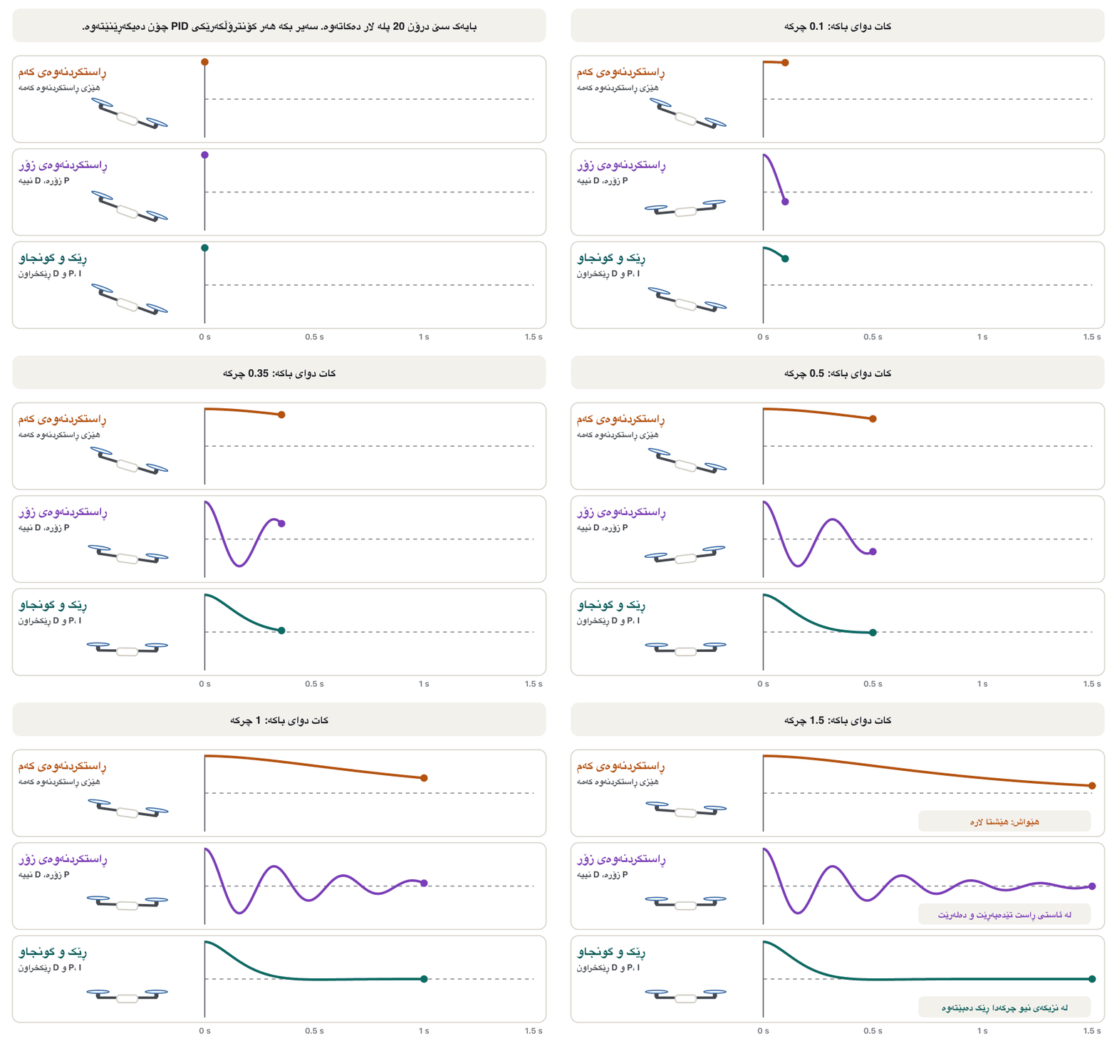
هەڵبژاردنی سێ ژمارەکە (، و ) پێی دەوترێت ڕێکخستن (tuning). سەیری سێ بکە کە هەمان با لێیان دەدات، هەریەکە بە ژمارەی جیاواز:
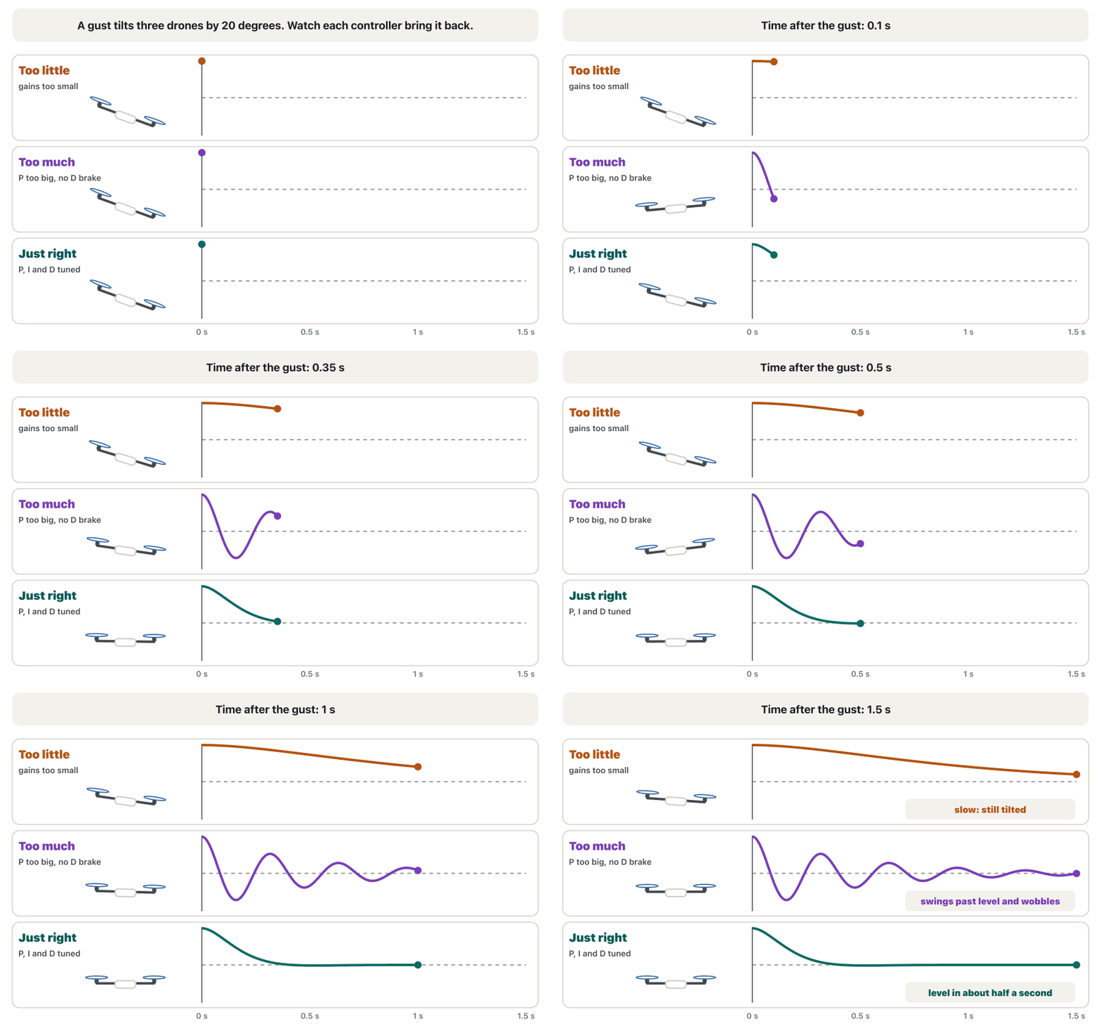
- Too little: the drone comes back slowly and drifts with the wind; it feels lazy.
- Too much P (and too little D): it swings past level and wobbles; PX4's tuning guide says a P gain that is too high shows as fast oscillations.
- Too much I gives slow oscillations; too much D makes the motors twitchy and hot, because D amplifies sensor noise.
- Just right: it returns in about half a second without wobbling; PX4 calls a good response "locked-in".
- کەم: بە هێواشی دەگەڕێتەوە و لەگەڵ بادا دەخلیسکێت؛ تەمبەڵ دیارە.
- P زۆر (و D کەم): لە ئاستی ڕاست تێدەپەڕێت و دەلەرێتەوە؛ ڕێبەری ڕێکخستنی PX4 دەڵێت P زۆر وەک لەرینەوەی خێرا دەردەکەوێت.
- I زۆر لەرینەوەی هێواش دروست دەکات؛ D زۆر دەلەرێنێت و گەرمیان دەکات، چونکە D گەورە دەکات.
- گونجاو: لە نزیکەی نیو چرکەدا بەبێ لەرینەوە دەگەڕێتەوە؛ PX4 بە وەڵامی باش دەڵێت «قوفڵدراو» (locked-in).
PID in plain wordsPID بە زمانێکی سادە
Optional: the PID formulaبۆ زیاتر زانین: هاوکێشەی PID
In words: the push back is the sum of three parts, each multiplied by its own gain. Doubling doubles the reaction to the present error; a bigger removes a steady offset faster; a bigger brakes harder against fast changes.
بە وشە: هێزی گەڕاندنەوە کۆی سێ بەشە و هەر بەشێک لە ژمارەی خۆی لێک دەدرێت. دووهێندەکردنی کاردانەوە بەرامبەر جیاوازیی ئێستا دوو هێندە دەکات؛ ئەگەر گەورەتر بێت، جیاوازییەکی جێگیر خێراتر لادەبات؛ ئەگەر گەورەتر بێت، بە توندتر بەرامبەر گۆڕانی خێرا دەوەستێتەوە.
Loops inside loopsخول لە ناو خولدا
A drone does not jump straight from "go to that point" to motor speeds. PX4 uses a cascade of loops, each giving the next its target. The position loop turns "where to go" into a wanted velocity. The velocity loop turns that into a wanted tilt and thrust. The angle (attitude) loop turns the tilt into a wanted turning rate. The rate loop, fed directly by the gyroscope, turns that into a turning effort (torque). The position and angle loops are simple P controllers; the velocity and rate loops are PID.
ڕاستەوخۆ لە «بڕۆ بۆ ئەو خاڵە»وە بازناداتە سەر خێرایی . PX4 زنجیرەیەک خول بەکار دەهێنێت کە هەر یەکێکیان ئامانجی خولی دواتر دیاری دەکات. خولی شوێن «بۆ کوێ بڕۆم» دەکاتە خێرایی ویستراو. خولی خێرایی ئەوە دەکاتە لاربوونەوە و ویستراو. خولی لاربوونەوەکە دەکاتە خێرایی سووڕانەوەی ویستراو. خولی خێرایی سووڕانەوە، کە ڕاستەوخۆ لە زانیاری وەردەگرێت، ئەوە دەکاتە . خولەکانی شوێن و کۆنترۆڵکەری سادەی Pـن؛ خولەکانی خێرایی و خێرایی سووڕانەوە PIDـن.
Last comes the mixer: it turns "this much thrust, this much roll, pitch and yaw" into one speed for each motor — the rules you met in All the moves in one picture. The inner loops run fastest, because tilt changes in milliseconds while position changes in seconds.
لە کۆتاییدا تێکەڵکەر (mixer) دێت: «ئەوەندە ، ئەوەندە ، و » دەکاتە یەک خێرایی بۆ هەر — ئەو یاسایانەی لە هەموو جووڵەکان لە یەک وێنەدا بینیت. خولەکانی ناوەوە خێراترین کار دەکەن، چونکە لاربوونەوە لە چەند میلیچرکەیەکدا دەگۆڕێت بەڵام شوێن لە چەند چرکەیەکدا.
Flight modesدۆخەکانی فڕین
A flight mode tells the autopilot how much to help. The names below are ArduPilot's (PX4's are similar: Stabilized, Altitude, Position, Mission, Return, Land). ArduPilot suggests that beginners learn them in this order: Stabilize, Alt Hold, Loiter, RTL, Auto.
بە دەڵێت چەند یارمەتی بدات. ناوەکانی خوارەوە هی ArduPilotـن (هی PX4ـیش هاوشێوەن: Stabilized، Altitude، Position، Mission، Return، Land). ArduPilot پێشنیار دەکات تازەکاران بەم ڕیزە فێریان ببن: Stabilize، Alt Hold، Loiter، RTL، Auto.
| Modeدۆخ | What the autopilot does چی دەکات | Needs GNSS?GNSSـی پێویستە؟ |
|---|---|---|
| Stabilize | keeps the drone level; the pilot controls height and position ڕێک ڕادەگرێت؛ فڕۆکەوان و شوێن کۆنترۆڵ دەکات | noنەخێر |
| Alt Hold | also holds the height with the barometer; the drone drifts with the wind بە ڕادەگرێت؛ لەگەڵ بادا دەخلیسکێت | noنەخێر |
| Loiter | also holds the position: let go of the sticks and it staysشوێنیش ڕادەگرێت: دەست لە دەسکەکان بەردە و دەمێنێتەوە | yesبەڵێ |
| Auto | flies a planned mission of waypoints by itselfخۆی ئەرکێکی پلاندانراو لە دەفڕێت | yesبەڵێ |
| Guided | flies to points sent live from a ground station or computerبۆ ئەو خاڵانە دەفڕێت کە ڕاستەوخۆ لە یان کۆمپیوتەرەوە دەنێردرێن | yesبەڵێ |
| RTL | returns home and lands (next lesson)دەگەڕێتەوە بۆ ماڵ و دەنیشێتەوە (وانەی داهاتوو) | yesبەڵێ |
| Land | comes down and lands where it isلە شوێنی خۆی دادەبەزێت و دەنیشێتەوە | noنەخێر |
| Acro | only holds turning rates: for experts and stuntsتەنیا خێرایی سووڕانەوە ڕادەگرێت: بۆ شارەزایان و نمایش | noنەخێر |
PX4, ArduPilot and ground stationsPX4، ArduPilot و وێستگەکانی کۆنترۆڵی زەمینی
PX4 and ArduPilot are the two big open-source autopilots: anyone may read, change and share their source code. PX4 uses the BSD 3-Clause licence and is hosted by the Dronecode Foundation, a Linux Foundation project; ArduPilot uses the GPLv3 licence. Both fly multirotors, fixed wings, VTOL aircraft, helicopters and ground rovers. Many camera drones from big makers run their own closed firmware instead.
PX4 و ArduPilot دوو گەورەی : هەر کەسێک دەتوانێت بخوێنێتەوە، بیگۆڕێت و بڵاوی بکاتەوە. PX4 BSD 3-Clause بەکار دەهێنێت و دامەزراوەی Dronecode، کە پرۆژەیەکی Linux Foundationـە، سەرپەرشتی دەکات؛ ArduPilot GPLv3 بەکار دەهێنێت. هەردووکیان دەتوانن ، ، فڕۆکەی VTOL و هەلیکۆپتەر بفڕێنن و ئۆتۆمبێلی زەمینیش بجووڵێنن. زۆرێک لە کامێرادار کە کۆمپانیا گەورەکان دروستیان دەکەن، لەبری ئەوانە داخراوی خۆیان بەکار دەهێنن.
On the ground the pilot uses a ground control station: software such as QGroundControl (for PX4 and ArduPilot; Windows, macOS, Linux, Android and iOS) or Mission Planner (for ArduPilot). It shows the telemetry — mode, battery, satellites, height, speed and a map — sends missions and changes settings over a radio link that speaks MAVLink (Telemetry and MAVLink).
لەسەر زەوی فڕۆکەوان بەکار دەهێنێت: وەک QGroundControl (بۆ PX4 و ArduPilot؛ Windows، macOS، Linux، Android و iOS) یان Mission Planner (بۆ ArduPilot). نیشان دەدات — ، ، مانگە دەستکردەکان، ، خێرایی و نەخشە — ئەرک دەنێرێت و ڕێکخستنەکان دەگۆڕێت بە پەیوەندییەکی ڕادیۆیی کە بە زمانی قسە دەکات (تەلەمەتری و MAVLink).
PX4, ArduPilot and ground stationsPX4، ArduPilot و وێستگەکانی کۆنترۆڵی زەمینی
Arming and pre-arm checksچالاککردنی ماتۆڕەکان و پشکنینەکانی پێش ئەو
Before take-off the pilot arms the drone: the motors become live and the propellers may start to spin. Before it allows this, the autopilot runs pre-arm checks: are the accelerometers and the compass calibrated, and do they agree? Is the barometer healthy? Is there a good GNSS fix for the modes that need one? Is the battery above its minimum, the radio calibrated, the EKF happy? If any check fails, it refuses to arm, the LED flashes yellow and the ground station shows the reason.
پێش هەڵفڕین فڕۆکەوان چالاک دەکات (): زیندوو دەبن و لەوانەیە دەست بە سووڕانەوە بکەن. پێش ئەوەی ڕێگە بەمە بدات، پشکنینەکانی پێش ئەنجام دەدات: ئایا و ڕێکخراون و یەک دەگرنەوە؟ ئایا تەندروستە؟ ئایا شوێنێکی باشی GNSS هەیە بۆ ئەو دۆخانەی پێویستیانە؟ ئایا لە سەرووی کەمترین ئاستەوەیە، ڕێکخراوە و EKF ڕازییە؟ ئەگەر یەک پشکنین سەرنەکەوێت، ڕێگە نادات، گڵۆپەکە زەرد دەترووسکێتەوە و هۆکارەکە نیشان دەدات.
Common mistakesهەڵە باوەکان
| Mistakeهەڵە | Betterباشتر |
|---|---|
| "The gyroscope measures height."« دەپێوێت.» | The gyroscope measures how fast the drone turns. Height comes from the barometer, a rangefinder and GNSS. دەپێوێت بە چ خێراییەک دەسووڕێتەوە. لە ، و GNSSـەوە دێت. |
| "GPS keeps the drone level."« ڕێک ڕادەگرێت.» | The IMU and the control loop keep it level, hundreds of times a second. GNSS only tells it where it is. و چەند سەد جار لە چرکەیەکدا ڕێکی ڕادەگرن. GNSS تەنیا دەڵێت لە کوێیە. |
| "Calibrating the compass next to a car or on a steel table is fine."«ڕێکخستنی لە تەنیشت ئۆتۆمبێل یان لەسەر مێزی ئاسن کێشە نییە.» | Steel and electric current bend the magnetic field. Calibrate in an open space, away from cars, metal and power lines.ئاسن و بواری موگناتیسی لا دەدەن. لە شوێنێکی کراوە، دوور لە ئۆتۆمبێل، ئاسن و هێڵی کارەبا ڕێکی بخە. |
| "Higher PID gains always make a better drone."«ژمارەی بەرزتری PID هەمیشە باشتر دروست دەکات.» | Too much P makes it wobble; too much D makes the motors hot and twitchy. Tune in small steps.P زۆر دەیلەرێنێت؛ D زۆر گەرم و لەرزۆک دەکات. هەنگاو بە هەنگاوی بچووک ڕێکی بخە. |
| "The barometer gives an exact height near the ground."« لە نزیک زەوی ورد دەدات.» | It drifts with the weather and the propellers' wash; a rangefinder is better for the last metres.لەگەڵ کەشوهەوا و بای دەگۆڕێت؛ بۆ دوا مەترەکان باشترە. |
| "If a pre-arm check fails, switch it off."«ئەگەر پشکنینێکی پێش سەرنەکەوت، بیکوژێنەوە.» | A failed check is a warning. Find and fix the cause.پشکنینی سەرنەکەوتوو ئاگادارکردنەوەیە. هۆکارەکە بدۆزەوە و چاکی بکەوە. |
| "Sensor fusion just averages all the sensors."« تەنیا ناوەندی هەموو دەدۆزێتەوە.» | An EKF predicts with the IMU, corrects with the others and rejects readings that disagree too much.EKF بە پێشبینی دەکات، بە ئەوانی تر ڕاستی دەکاتەوە و ئەو خوێندنەوانە ڕەت دەکاتەوە کە زۆر جیاوازن. |
Exercisesڕاهێنانەکان
Write the PEAS description (Performance measure, Environment, Actuators, Sensors) of a drone that carries medicine from a hospital in Erbil to clinics in nearby villages. Use the format of PEAS.
وەسفی PEAS (، ژینگە، ، ) بۆ بنووسە کە دەرمان لە نەخۆشخانەیەکی هەولێرەوە بۆ بنکە تەندروستییەکانی گوندە نزیکەکان دەبات. شێوازی PEAS بەکار بهێنە.
Hintئاماژە
Sensors measure, actuators act; the performance measure says what a good delivery looks like.
دەپێون، کار دەکەن؛ دەڵێت گەیاندنێکی باش چۆنە.
Show answerوەڵامەکە پیشان بدە
- P: the parcel arrives on time and undamaged; nobody is hurt; the flight stays legal and inside its geofence; little battery is used.
- E: the air over the city and villages, wind, rain and dust, buildings, power lines, birds and other aircraft, the landing spots and the people below.
- A: the motors with their ESCs and propellers, a release hook or winch, lights and a buzzer, and the radio that sends telemetry.
- S: the IMU (gyroscope and accelerometer), magnetometer, barometer, GNSS, rangefinder, obstacle sensors and cameras, the battery monitor and the radio receiver.
- P: بارەکە لە کاتی خۆیدا و بێ زیان دەگات؛ کەس ئازار نابینێت؛ فڕینەکە یاسایی دەبێت و لە ناو دەمێنێتەوە؛ کەمترین وزەی بەکار دەهێنرێت.
- E: ئاسمانی سەر شار و گوندەکان، با، باران و تۆز، باڵەخانە، هێڵی کارەبا، باڵندە و فڕۆکەی تر، شوێنەکانی نیشتنەوە و خەڵکی خوارەوە.
- A: لەگەڵ و ، قولاپ یان وینجی بەردانەوەی بار، گڵۆپ و زەنگ، هەروەها ئەو ڕادیۆیەی دەنێرێت.
- S: ( و )، ، ، GNSS، ، بەربەست و کامێرا، پێوەری و .
Name the main sensor for each job: (a) know which way the nose points; (b) hold the height in Alt Hold; (c) land gently on a pad; (d) hold still under a bridge where there is no GNSS; (e) feel a gust tilting the drone.
بۆ هەر کارێک سەرەکی ناو ببە: (أ) زانینی ئەوەی لووت ڕووی لە کام لایە؛ (ب) ڕاگرتنی لە Alt Holdـدا؛ (ج) نیشتنەوەی هێمن لەسەر شوێنی نیشتنەوە؛ (د) ڕاوەستان لە ژێر پردێکدا کە GNSS نییە؛ (هـ) هەستکردن بەو بایەی لار دەکاتەوە.
Show answerوەڵامەکە پیشان بدە
- (a) magnetometer; (b) barometer; (c) downward rangefinder; (d) optical flow with a rangefinder; (e) gyroscope (in the IMU).
- (أ) ؛ (ب) ؛ (ج) ڕوو لە خوارەوە؛ (د) لەگەڵ ؛ (هـ) (لە ناو ).
A copter runs its main loop 400 times a second and flies at 10 m/s. How far does it move between two corrections? How far if the rate loop runs 4,000 times a second?
خولە سەرەکییەکەی 400 جار لە چرکەیەکدا کار پێ دەکات و بە خێرایی 10 مەتر لە چرکەیەکدا دەفڕێت. لە نێوان دوو ڕاستکردنەوەدا چەند دەڕوات؟ ئەگەر خولی خێرایی سووڕانەوە 4000 جار لە چرکەیەکدا کار بکات چەند؟
Show answerوەڵامەکە پیشان بدە
At 400 Hz the drone moves only 2.5 cm between corrections; at 4 kHz only 2.5 mm.
لە 400 هێرتزدا لە نێوان دوو ڕاستکردنەوەدا تەنیا 2.5 سانتیمەتر دەڕوات؛ لە 4 کیلۆهێرتزدا تەنیا 2.5 میلیمەتر.
Three test flights: (a) after a gust the drone takes a long time to level and drifts in the wind; (b) it shakes quickly back and forth after every stick movement; (c) it flies steadily, but the motors are hot after landing and sound rough. Which gain is probably wrong each time?
سێ فڕینی تاقیکردنەوە: (أ) دوای با ماوەیەکی زۆری پێدەچێت تا ڕێک ببێتەوە و لەگەڵ بادا دەخلیسکێت؛ (ب) دوای هەموو جووڵاندنێکی دەسکەکان بە خێرایی سەر و خوار دەلەرێتەوە؛ (ج) جێگیر دەفڕێت، بەڵام دوای نیشتنەوە گەرمن و دەنگیان ناڕێکە. لە هەر جارێکدا کام ژمارە ئەگەری هەیە هەڵە بێت؟
Show answerوەڵامەکە پیشان بدە
- (a) P (and perhaps I) is too low: the correction is too weak.
- (b) P is too high, or D too low to brake the swing.
- (c) D is too high: it amplifies sensor noise, so the motors work hard all the time.
- (أ) P (و لەوانەیە I) کەمە: ڕاستکردنەوەکە زۆر لاوازە.
- (ب) P زۆرە، یان D کەمە بۆ ئەوەی لەرینەوەکە ڕابگرێت.
- (ج) D زۆرە: گەورە دەکات، بۆیە هەمیشە بە توندی کار دەکەن.
Summaryپوختە
- The flight controller is a microcontroller board running an autopilot (PX4, ArduPilot): it processes inputs and controls the flight.
- At least four sensors: gyroscope and accelerometer (the IMU), magnetometer and barometer; plus GNSS, rangefinder, optical flow and obstacle sensors.
- Each sensor can be fooled; sensor fusion (an EKF) predicts with the IMU and corrects with the others.
- The control loop measures, compares with the set point and corrects — 400 times a second in ArduCopter.
- PID: P for the present error, I for the past, D for the future; tuning finds gains that are neither lazy nor wobbly.
- Loops sit inside loops (position → velocity → angle → rate → mixer); flight modes decide how much the autopilot helps; pre-arm checks must never be switched off.
- بۆردێکی کە (PX4، ArduPilot) کار پێ دەکات: چارەسەر دەکات و فڕینەکە کۆنترۆڵ دەکات.
- لانیکەم چوار : و ()، و ؛ هەروەها GNSS، ، و بەربەست.
- هەموو هەڵدەخەڵەتێت؛ (EKF) بە پێشبینی دەکات و بە ئەوانی تر ڕاستی دەکاتەوە.
- دەپێوێت، لەگەڵ بەراورد دەکات و ڕاست دەکاتەوە — لە ArduCopterـدا 400 جار لە چرکەیەکدا.
- PID: P بۆ جیاوازیی ئێستا، I بۆ ڕابردوو، D بۆ داهاتوو؛ ڕێکخستن ئەو ژمارانە دەدۆزێتەوە کە نە تەمبەڵن نە لەرزۆک.
- خول لە ناو خولدان (شوێن ← خێرایی ← ← خێرایی سووڕانەوە ← تێکەڵکەر)؛ دیاری دەکەن چەند یارمەتی بدات؛ نابێت هەرگیز پشکنینەکانی پێش بکوژێنرێنەوە.
Why does a drone need both a gyroscope and an accelerometer?بۆچی درۆن پێویستی بە جایرۆسکۆپ و ئەکسێلەرۆمیتەر پێکەوە هەیە؟
The gyroscope is smooth but drifts over time; the accelerometer knows where down is but is noisy. Fused together they give a tilt that is both smooth and correct.
ڕێکە بەڵام بە تێپەڕبوونی کات لادەدات؛ دەزانێت خوارەوە کامەیە بەڵام زۆرە. کاتێک یەک دەخرێن لاربوونەوەیەک دەدەن کە هەم ڕێکە و هەم دروست.
What happens in one turn of the control loop?لە یەک سووڕی خولی کۆنترۆڵدا چی ڕوودەدات؟
The sensors measure, the autopilot estimates the state, compares it with the set point and computes a correction, and the ESCs change the motor speeds.
دەپێون، دۆخەکە مەزەندە دەکات، لەگەڵ بەراوردی دەکات و ڕاستکردنەوەیەک هەژمار دەکات، پاشان خێراتر یان هێواشتر دەکەن.
Which flight mode would you use if GNSS stops working, and why?ئەگەر GNSS کار نەکات کام دۆخی فڕین بەکار دەهێنیت و بۆچی؟
Alt Hold (or Stabilize): they need no position, so you can fly by eye and land; Loiter, Auto and RTL depend on GNSS.
Alt Hold (یان Stabilize): پێویستیان بە شوێن نییە، بۆیە دەتوانیت بە چاو بفڕیت و بنیشیتەوە؛ Loiter، Auto و RTL پشت بە GNSS دەبەستن.
Lesson complete!وانەکە تەواو بوو!
Well done. Review the key terms, then go on to the next lesson.دەستخۆش. سەیرێکی زاراوە سەرەکییەکان بکەرەوە، پاشان بڕۆ بۆ وانەی داهاتوو.
Key termsزاراوە سەرەکییەکان
GNSS Navigation, Return-to-Home, Geofences and Failsafesڕێنیشاندەری GNSS، گەڕانەوە بۆ ماڵ، پەرژینەکانی جوگرافی و سەلامەتیی کاتی تێکچوون
Related lecturesوانە پەیوەندیدارەکان
- Inside a Drone: Frame, Motors, ESCs and Propellersناو درۆن: چوارچێوەی درۆن، ماتۆڕەکان، کۆنترۆڵکەرەکانی خێرایی و پەروانەکان
- GNSS Navigation, Return-to-Home, Geofences and Failsafesڕێنیشاندەری GNSS، گەڕانەوە بۆ ماڵ، پەرژینەکانی جوگرافی و سەلامەتیی کاتی تێکچوون
- Radio Links: Remote Control, Telemetry, FPV Video and 5Gپەیوەندیی ڕادیۆیی: کۆنترۆڵی دوور، تەلەمەتری، ڤیدیۆی FPV و 5G
- Autonomy, Swarms, Air Taxis and the Future of Dronesسەربەخۆیی، ڕەوەکانی درۆن، تەکسییە ئاسمانییەکان و داهاتووی درۆنەکان
- The CPU: Control Unit, ALU and CoresCPU: یەکەی جڵەوکردن، ALU و ناوکەکانی پرۆسێسەر
- Emerging Technologies: IoT, VR/AR, Robots and Blockchainتەکنەلۆجیا نوێیەکان: ئینتەرنێتی شتەکان، ڕاستیی گریمانەیی/ڕاستیی زیادکراو، ڕۆبۆتەکان و بلۆکچەین
- Agents, Sensors and Actuators; Rational Agentsئەیجێنتەکان، هەستەوەرەکان و جووڵێنەرەکان؛ ئەیجێنتە عەقڵانییەکان
- Task Environments: PEAS and the Eight Propertiesژینگەکانی ئەرک: PEAS و هەشت تایبەتمەندییەکە
- How AI Sees: Sensors, Computer Vision and Detectionژیریی دەستکرد چۆن دەبینێت: هەستەوەرەکان، بینایی کۆمپیوتەر و دۆزینەوە
- Autonomous Drones, Vehicles and Robotsدرۆن، ئۆتۆمبێل و ڕۆبۆتی سەربەخۆ
- Decisions, Human Control and Responsibilityبڕیار، کۆنترۆڵی مرۆڤ و بەرپرسیارێتی
References and further readingسەرچاوەکان و خوێندنەوەی زیاتر
- PX4 User Guide: Basic concepts (autopilot, minimum sensors, flight modes, arming, failsafes)
- PX4 User Guide: Controller diagrams (cascaded P and PID controllers)
- PX4 User Guide: Using the ECL EKF (EKF2: IMU prediction, sensor corrections)
- PX4 User Guide: Multicopter PID tuning guide (manual/advanced)
- PX4 User Guide: Holybro Pixhawk 6X (processor, redundant IMUs and barometers, vibration isolation)
- PX4 Autopilot User Guide (BSD 3-Clause licence, Dronecode Foundation)
- ArduPilot Copter: Flight modes (GPS-dependent modes, recommended order)
- ArduPilot Copter: Aggressive rate loop tuning (400 Hz main loop, fast rate thread up to 4 kHz)
- ArduPilot: Extended Kalman Filter navigation overview (EKF3 default)
- ArduPilot Copter: Altitude Hold mode (barometer, prop wash, weather)
- ArduPilot (archived): APM 2.5 and 2.6 overview (cover the barometer with open-cell foam)
- ArduPilot: Rangefinders (lidar, sonar, radar, ToF; use near the ground)
- ArduPilot: Object avoidance (proximity sensors, rangefinders, depth cameras)
- ArduPilot: Pre-arm safety checks
- ArduPilot Copter: Arming the motors
- ArduPilot: GPLv3 licence
- QGroundControl User Guide
- ArduPilot: Mission Planner
This lecture is a first edition. The Kurdish text and terminology are waiting for review by Kurdish IT teachers.ئەم وانەیە چاپی یەکەمە. دەقە کوردییەکە و زاراوەکانی چاوەڕێی پێداچوونەوەی مامۆستایانی کوردی بواری IT ن.