Chapterبەش 3 · Lectureوانە 3.3
Payloads and Mapping: Cameras, Thermal, LiDAR and Photogrammetryباری درۆن و نەخشەکێشان: کامێرا، گەرمی، لایدار و فۆتۆگرامێتری
What drones carry and how they map: payloads and their cost, cameras and gimbals, ground sample distance with worked examples, thermal cameras (radiometric or not), multispectral cameras and NDVI, LiDAR and point clouds, photogrammetry with overlap and orthomosaics, planning a mapping flight, ground control points and check points, and when to choose LiDAR or photogrammetry.
چی هەڵدەگرن و چۆن نەخشە دەکێشن: بار و نرخەکەی، کامێرا و ، بە نموونەی هەژمارکراو، (پلەپێو یان نا)، و NDVI، و ، بە بەسەریەکداچوون و ، پلاندانانی فڕینی نەخشەکێشان، و خاڵەکانی پشکنین و کەی یان هەڵبژێریت.
What you will learnچی فێر دەبیت
- Explain what a payload is, what it costs the drone, and what a gimbal does.
- Calculate a ground sample distance and the height needed for a given detail.
- Explain thermal (radiometric and not) and multispectral cameras, and calculate NDVI.
- Explain how LiDAR measures distance () and how photogrammetry builds 3D maps and orthomosaics from overlapping photos.
- Plan a mapping flight with overlap, ground control points and check points, and choose between LiDAR and photogrammetry.
- ڕوونی بکەیتەوە چییە، چی لە دەستێنێت و چی دەکات.
- و ئەو بەرزییەی بۆ وردەکارییەکی دیاریکراو پێویستە هەژمار بکەیت.
- (پلەپێو و ناپلەپێو) و ڕوون بکەیتەوە و NDVI هەژمار بکەیت.
- ڕوونی بکەیتەوە چۆن دووری دەپێوێت () و چۆن لە وێنەی بەسەریەکداچووەوە نەخشەی سێ ڕەهەندی و دروست دەکات.
- فڕینێکی نەخشەکێشان بە بەسەریەکداچوون، و خاڵی پشکنین پلان بکەیت و لە نێوان و هەڵبژێریت.
What a drone carries: the payloadدرۆن چی هەڵدەگرێت: باری درۆن
Whatever a carries to do its job, beyond what it needs to fly: cameras, , a parcel or a spray tank. A heavier payload means a shorter flight.
ئەو شتەیە کە بۆ ئەنجامدانی کارەکەی هەڵیدەگرێت، جگە لەوەی بۆ فڕین پێویستیەتی: کامێرا، ، پاکەتێک یان تانکێکی دەرمانپڕژێن. بارێکی قورستر واتە فڕینێکی کورتتر.
A drone's payload is what it carries to do its job, beyond what it needs to fly: cameras and other imaging sensors, a parcel, a spray tank, a loudspeaker or a light. The payload turns a flying machine into a tool: the same quadcopter can film a wedding, inspect a roof or map a field (Drones at work).
ئەو شتەیە کە بۆ ئەنجامدانی کارەکەی هەڵیدەگرێت، جگە لەوەی بۆ فڕین پێویستیەتی: کامێرا و تری وێنەگرتن، پاکەتێک، تانکێکی دەرمانپڕژێن، بڵندگۆیەک یان گڵۆپێک. بار ئامێرێکی فڕیو دەکات بە ئامرازێکی کار: هەمان دەتوانێت ڤیدیۆی ئاهەنگێک بگرێت، سەربانێک بپشکنێت یان نەخشەی کێڵگەیەک بکێشێت (درۆنەکان لە کاردا).
Every payload has a cost. It adds weight, so the flight is shorter (flight time); the drone must stay under its maximum take-off weight (one 951 g mapping drone may take off at no more than 1,050 g); the payload must sit near the centre of gravity and be fixed firmly; and it often needs power and data from the drone. A survey LiDAR alone weighs about 1 to 1.6 kg (2026 models). In cybersecurity, means something else: the harmful part of malware.
هەر بارێک نرخی خۆی هەیە. کێش زیاد دەکات، بۆیە فڕینەکە کورتتر دەبێت (کاتی فڕین)؛ دەبێت لە خوار زۆرترین کێشی هەڵفڕینی خۆیەوە بمێنێتەوە ( نەخشەکێشانی 951 گرامی زۆرترین بە 1,050 گرام دەتوانێت هەڵبفڕێت)؛ بارەکە دەبێت لە نزیک ناوەندی قورسایییەوە بێت و توند ببەسترێت؛ زۆرجاریش کارەبا و لە پێویستە. ڕووپێوی بە تەنیا نزیکەی 1 تا 1.6 کیلۆگرامە (مۆدێلەکانی 2026). لە ئاسایشی سایبەریدا مانایەکی تری هەیە: بەشە زیانبەخشەکەی .
Cameras and gimbalsکامێرا و گیمباڵەکان
Cameras and imaging sensors are the most common payloads. An ordinary colour camera records the light we see. For mapping, a larger sensor, a fixed lens and a shutter that exposes the whole picture at once are best, so that photos taken while moving are sharp and not skewed.
کامێرا و وێنەگرتن باوترین بارن. کامێرای ڕەنگیی ئاسایی ئەو ڕووناکییە تۆمار دەکات کە ئێمە دەیبینین. بۆ نەخشەکێشان، گەورەتر، هاوێنەی جێگیر و شاتەرێک کە هەموو وێنەکە لە یەک کاتدا دەگرێت باشترینن، بۆ ئەوەی ئەو وێنانەی لە کاتی جووڵەدا دەگیرێن ڕوون بن و لار نەبن.
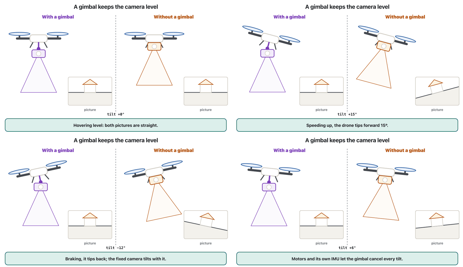
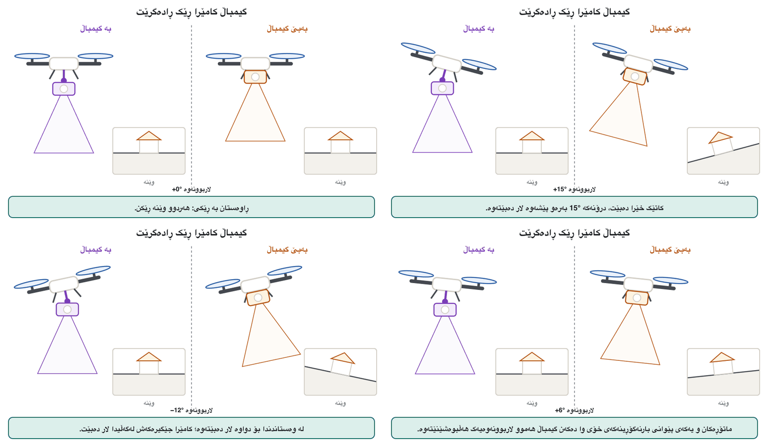
The camera hangs on a : a holder with small brushless motors on two or three axes (pitch or tilt, roll, and yaw or pan) and its own IMU. When the drone tips forward to speed up, or a gust rolls it, the gimbal turns the camera the other way at once, so the picture stays level and smooth (pitch and roll). The gimbal also points the camera: straight down (nadir) for maps, or at an angle (oblique) for walls and 3D models.
کامێراکە بە هەڵدەواسرێت: ڕاگرێک بە بچووک لەسەر دوو یان سێ تەوەر (، و ) و تایبەت بە خۆی. کاتێک بۆ خێرابوون بەرەو پێشەوە لار دەبێتەوە، یان بایەک لاری دەکاتەوە، یەکسەر کامێراکە بە پێچەوانەوە دەسووڕێنێت، بۆیە وێنەکە ڕێک و نەرم دەمێنێتەوە (لێژی و لاربوونەوە). ئاڕاستەی کامێراکەش دیاری دەکات: ڕاستەوخۆ بەرەو خوارەوە بۆ نەخشە، یان بە گۆشەیەک بۆ دیوار و مۆدێلی سێ ڕەهەندی.
The parts of a camera and what each one does: the lens and focus, the aperture, the shutter and the image sensor with its millions of pixels, compared with the human eye.
بەشەکانی کامێرا و کاری هەریەکەیان: هاوێنە (lens) و ڕێکخستنی ڕوونی، کونی ڕووناکی (aperture)، shutter و وێنە بە ملیۆنان ، بەراورد بە چاوی مرۆڤ.
Watch 0:00–11:28: lens, aperture, shutter and sensor, compared with the eye; the gimbal is not in this video.
لە 0:00 تا 11:28 سەیر بکە: هاوێنە، کونی ڕووناکی، shutter و ، بەراورد بە چاو؛ لەم ڤیدیۆیەدا نییە.
How much detail? Ground sample distanceچەند وردەکاری؟ قەبارەی پیکسڵ لەسەر زەوی
How much detail a mapping photo shows depends on its (GSD): the size of one pixel on the ground. A GSD of 2 cm means each pixel covers 2 cm × 2 cm, so a smaller GSD shows more detail. It follows from the camera's geometry:
ئەوەی وێنەیەکی نەخشەکێشان چەند وردەکاری پیشان دەدات بەندە بە (GSD): قەبارەی یەک لەسەر زەوی. GSDـی 2 سانتیمەتر واتە هەر 2 cm × 2 cm دەگرێتەوە، بۆیە GSDـی بچووکتر وردەکاریی زیاتر پیشان دەدات. لە ئەندازەی کامێراکەوە دێت:
= sensor width (mm), = height above the ground (m), = focal length (mm), = image width (pixels); the answer is in metres per pixel (× 100 for cm)
= پانیی (mm)، = بەرزی لە سەر زەوییەوە (m)، = (mm)، = پانیی وێنە ()؛ وەڵامەکە بە مەترە بۆ هەر (× 100 بۆ سانتیمەتر)
Example: a camera with a 1-inch sensor (), and photos 5,472 pixels wide, flying at 100 m: , about 2.7 cm per pixel, and each photo covers about 150 m × 100 m. Half the height gives half the GSD: a USGS shoreline survey flew at 70 m for 1.8 cm per pixel and at 35 m for 0.9 cm.
نموونە: کامێرایەک بە 1 ئینج ()، و وێنەی 5,472 پان، لە بەرزیی 100 مەترەوە: ، واتە نزیکەی 2.7 سانتیمەتر بۆ هەر و هەر وێنەیەک نزیکەی 150 m × 100 m دەگرێتەوە. نیوەی بەرزی نیوەی GSD دەدات: ڕووپێوییەکی USGS لە کەناری دەریا لە 70 مەترەوە 1.8 سانتیمەتر و لە 35 مەترەوە 0.9 سانتیمەتری بۆ هەر دا.
Thermal camerasکامێرا گەرمییەکان
A sees the infrared that warm things give off (Thermal cameras: seeing heat). Drone thermal cameras usually see long-wave infrared (8–14 µm), with far fewer pixels than a photo camera: 640 × 512 is common. They find faulty solar cells, wet patches in roofs, leaking pipes, overheating parts of power lines and fire hotspots through smoke, and help to search for people or animals at night, although a warm spot is not always a person (AI that protects).
ئەو دەبینێت کە شتە گەرمەکان دەری دەدەن (کامێرا گەرمییەکان: بینینی گەرمی). زۆرجار شەپۆل درێژ (8 تا 14 µm) دەبینن، بە زۆر کەمتر لە کامێرای وێنە: 640 × 512 باوە. خانەی خراپی پانێڵی خۆر، شوێنی تەڕی سەربان، بۆریی دزەکردوو، بەشە زۆر گەرمبووەکانی هێڵی کارەبا و شوێنی گەرمی ئاگر لە ناو دووکەڵدا دەدۆزنەوە و یارمەتی دەدەن لە شەودا بەدوای مرۆڤ یان ئاژەڵدا بگەڕێین، هەرچەندە شوێنێکی گەرم هەمیشە مرۆڤ نییە (ژیریی دەستکرد کە دەپارێزێت).
There are two kinds. A radiometric camera stores a temperature in every pixel, so you can measure it afterwards; a non-radiometric one makes only a picture of warmer and cooler. Even radiometric readings are only about ±2 °C accurate, and a surface's emissivity and reflections can make them wrong: shiny metal reflects the heat of other things. Set the emissivity of the material before you trust a number.
دوو جۆر هەن. لە هەر پلەیەکی گەرمی هەڵدەگرێت، بۆیە دواتر دەتوانیت بیپێویت؛ کامێرای ناپلەپێو تەنیا وێنەیەکی گەرمتر و ساردتر دروست دەکات. تەنانەت خوێندنەوەی پلەپێویش تەنیا بە نزیکەی ±2 °C وردە و و دانەوەی ڕووەکان دەتوانن خوێندنەوەکە هەڵە بکەن: کانزای بریقەدار گەرمیی شتەکانی تر دەداتەوە. پێش ئەوەی متمانە بە ژمارەیەک بکەیت، ماددەکە ڕێک بخە.
Multispectral cameras and NDVIکامێرا فرەشەبەنگەکان و NDVI
A takes several pictures at once, each through a narrow band of light, for example green (560 nm), red (650 nm), red edge (730 nm) and near-infrared (860 nm). Plants show their health in these bands: the chlorophyll in healthy leaves absorbs most visible light (0.4–0.7 µm) for photosynthesis, while the leaves' cell structure strongly reflects near-infrared light (0.7–1.1 µm), which our eyes cannot see. A light sensor on top of the drone measures the sunlight, so that pictures taken in sun and under clouds can be compared.
لە یەک کاتدا چەند وێنەیەک دەگرێت، هەریەکەیان لە ڕێگەی باندێکی تەسکی ڕووناکییەوە، بۆ نموونە سەوز (560 nm)، سوور (650 nm)، لێواری سوور (730 nm) و نزیک (860 nm). ڕووەکەکان تەندروستیی خۆیان لەم باندانەدا پیشان دەدەن: کلۆرۆفیلی گەڵای تەندروست زۆربەی ڕووناکیی بینراو (0.4 تا 0.7 µm) بۆ ڕۆشنەپێکهاتن هەڵدەمژێت، بەڵام پێکهاتەی خانەکانی گەڵا نزیک (0.7 تا 1.1 µm) بە بەهێزی دەداتەوە کە چاومان نایبینێت. ڕووناکی لەسەر ڕووناکیی خۆر دەپێوێت، بۆ ئەوەی وێنەی ژێر خۆر و ژێر هەور بەراورد بکرێن.
Multispectral cameras and NDVIکامێرا فرەشەبەنگەکان و NDVI
NDVI: one number for plant healthNDVI: یەک ژمارە بۆ تەندروستیی ڕووەک
The (normalized difference vegetation index) turns two of the bands into one number for every pixel, from −1 to +1:
(پێوەری جیاوازیی ئاسایکراوی ڕووەک) دوو لە باندەکان دەکات بە یەک ژمارە بۆ هەر ، لە −1 تا +1:
Example: a healthy leaf reflects 0.50 of the near-infrared and 0.08 of the red light: . A stressed leaf reflecting 0.30 and 0.12 scores . NASA's guide: about 0 means no vegetation, 0.1 or less rock, sand or snow, 0.2–0.3 shrubs and grass, 0.6–0.8 rainforest, and 0.8–0.9 the densest leaves. An NDVI map shows a farmer where to look: a dry patch, a disease or a broken irrigation pipe (precision agriculture).
نموونە: گەڵایەکی تەندروست 0.50ی نزیک و 0.08ی ڕووناکیی سوور دەداتەوە: . گەڵایەکی لاواز کە 0.30 و 0.12 دەداتەوە، وەردەگرێت. بەپێی ڕێبەری NASA: نزیکەی 0 واتە هیچ ڕووەکێک نییە، 0.1 یان کەمتر بەرد، لم یان بەفر، 0.2 تا 0.3 دەوەن و گیا، 0.6 تا 0.8 دارستانی باراناوی و 0.8 تا 0.9 چڕترین گەڵا. نەخشەی NDVI پیشانی جووتیار دەدات بۆ کوێ بڕوانێت: شوێنێکی وشک، نەخۆشییەک یان بۆرییەکی ئاودێریی شکاو (کشتوکاڵی ورد).
LiDAR: measuring with laser lightلایدار: پێوان بە ڕووناکیی لەیزەر
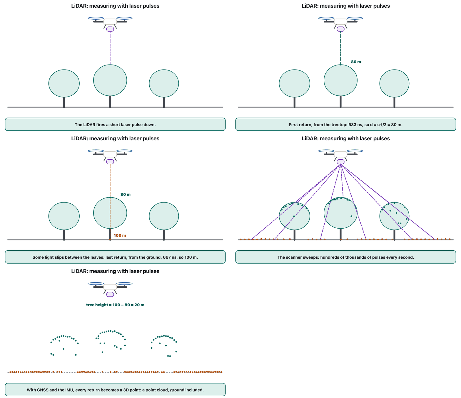
Better sensing is one of the big advances in drones, and (light detection and ranging) is the clearest example: it builds detailed 3D maps. A LiDAR sends short laser pulses and times their echoes. Light goes there and back at about 300,000 km per second, so the distance is:
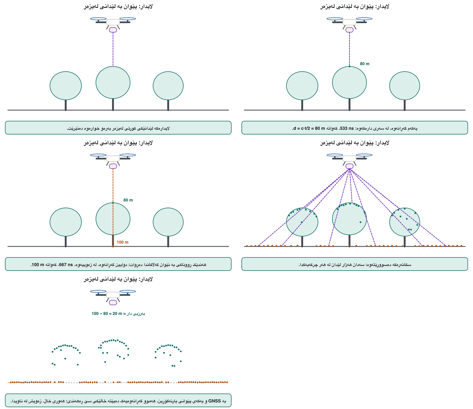
هەستکردنی باشتر یەکێکە لە پێشکەوتنە گەورەکانی و ڕوونترین نموونەیە: نەخشەی سێ ڕەهەندیی ورد دروست دەکات. لێدانی کورتی دەنێرێت و کاتی گەڕانەوەیان دەپێوێت. ڕووناکی بە نزیکەی 300,000 کیلۆمەتر لە چرکەیەکدا دەچێت و دەگەڕێتەوە، بۆیە دووری ئەمەیە:
is the distance, the speed of light and the time the pulse needs there and back; divide by 2 because the light covers the distance twice.
دوورییە، خێرایی ڕووناکییە و ئەو کاتەیە کە لێدانەکە دەچێت و دەگەڕێتەوە؛ دابەشی 2 دەکەین، چونکە ڕووناکی دوورییەکە دوو جار دەبڕێت.
An echo after 0.5 microseconds means . The drone's GNSS and IMU record exactly where the sensor was and where it pointed, so every echo becomes a point with latitude, longitude and height (NOAA). Part of one pulse can bounce off a leaf and the rest off the ground below, so a pulse can give several returns; the last is often the ground under the trees. Land LiDAR uses near-infrared light; bathymetric LiDAR uses green light that enters water to map river and sea beds.
گەڕانەوەیەک دوای 0.5 مایکرۆچرکە واتە . و بە وردی تۆمار دەکەن لە کوێ بوو و ڕووی لە کوێ بوو، بۆیە هەر گەڕانەوەیەک دەبێتە خاڵێک بە هێڵی پانی، هێڵی درێژی و بەرزی (NOAA). بەشێک لە یەک لێدان دەتوانێت لە گەڵایەکەوە بگەڕێتەوە و ئەوی تر لە زەویی ژێرییەوە، بۆیە یەک لێدان دەتوانێت چەند گەڕانەوەیەک بدات؛ دوایینیان زۆرجار زەویی ژێر دارەکانە. وشکانی نزیک بەکار دەهێنێت؛ ژێرئاو ڕووناکیی سەوز بەکار دەهێنێت کە دەچێتە ناو ئاوەوە بۆ نەخشەکێشانی بنی ڕووبار و دەریا.
LiDAR: measuring with laser lightلایدار: پێوان بە ڕووناکیی لەیزەر
Point cloudsهەورەکانی خاڵ
The result of a LiDAR flight is a : millions of measured points, often coloured by height or with the colours of photos taken at the same time. From it, software separates the ground from trees and buildings, makes a terrain model of the bare earth, measures the heights of trees and the volume of stockpiles, and traces roads, power lines and walls. Drone survey LiDARs sold in 2026 fire from about 240,000 to 2 million laser pulses a second, and the finished points are accurate to a few centimetres (about 3–4 cm from 120 m for one 2026 model). So point clouds are big: a single survey can hold hundreds of millions of points.
ئەنجامی فڕینێکی : ملیۆنان خاڵی پێوراو، زۆرجار بەپێی بەرزی ڕەنگکراو یان بە ڕەنگی ئەو وێنانەی لە هەمان کاتدا گیراون. لێیەوە زەوی لە دار و باڵەخانە جیا دەکاتەوە، مۆدێلێکی زەویی ڕووت دروست دەکات، بەرزیی دار و قەبارەی کۆگای خۆڵ و بەرد دەپێوێت و ڕێگا، هێڵی کارەبا و دیوارەکان دیاری دەکات. ڕووپێویی کە لە 2026دا دەفرۆشرێن لە نزیکەی 240,000 تا 2 ملیۆن لێدانی لە چرکەیەکدا دەنێرن و خاڵە کۆتاییەکانیان تا چەند سانتیمەترێک وردن (بۆ مۆدێلێکی 2026 نزیکەی 3 تا 4 سانتیمەتر لە بەرزیی 120 مەترەوە). بۆیە گەورەن: یەک ڕووپێوی دەتوانێت سەدان ملیۆن خاڵی تێدا بێت.
Photogrammetry: 3D from many photosفۆتۆگرامێتری: سێ ڕەهەندی لە چەندین وێنەوە
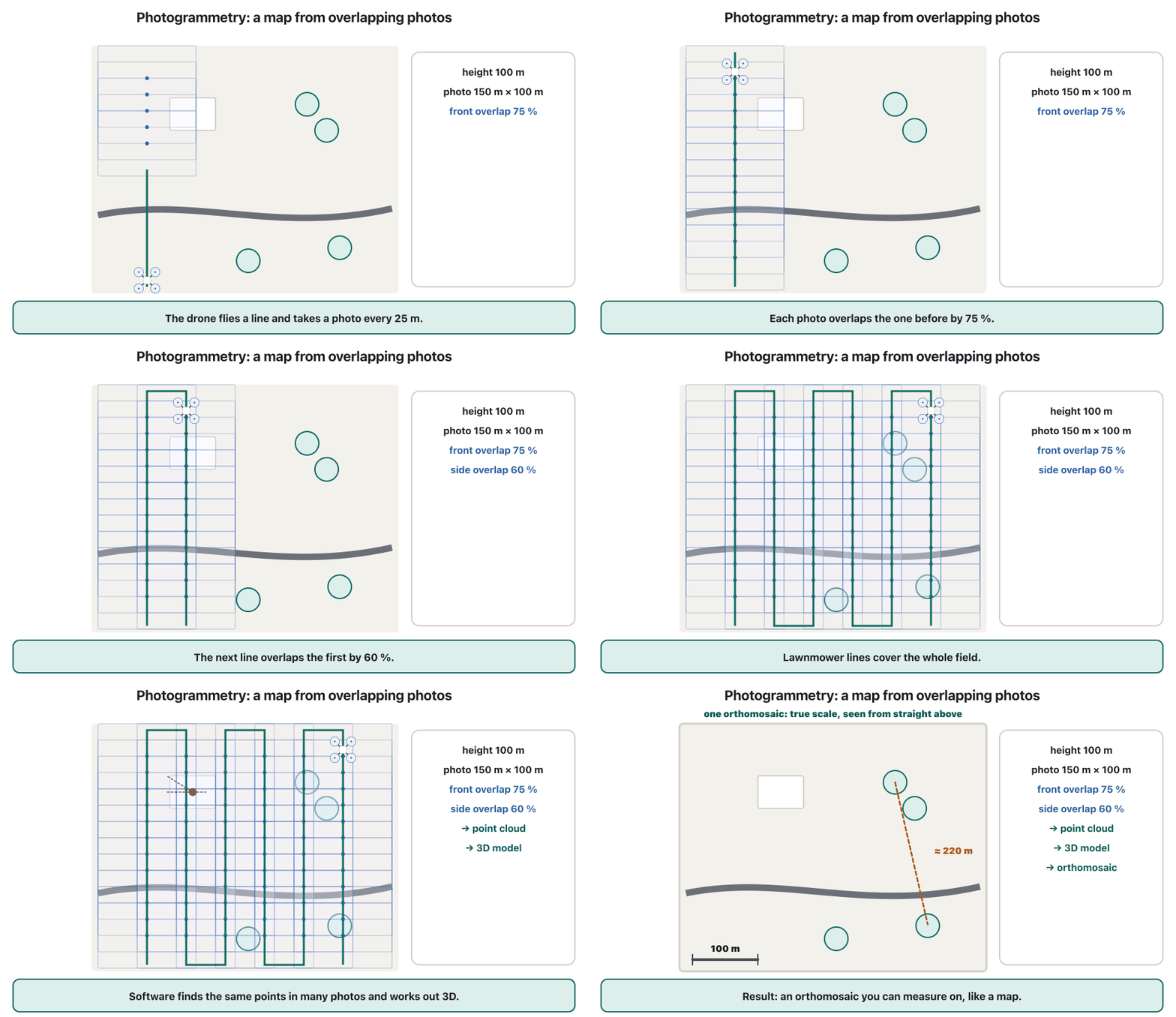
measures the world from photos. The drone flies a grid of parallel lines, a "lawnmower" pattern, taking overlapping photos. Software ("structure from motion") finds the same small features in many photos, works out where each photo was taken from, and then the 3D position of millions of points: a point cloud, a 3D model, a surface model and an .
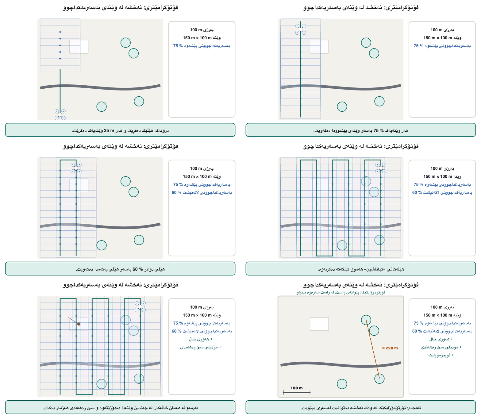
جیهان لە ڕێگەی وێنەوە دەپێوێت. تۆڕێک لە هێڵی تەریب بە شێوازی «گیاتاشین» دەفڕێت و وێنەی بەسەریەکداچوو دەگرێت. (بونیاد لە جووڵەوە، structure from motion) هەمان وردە نیشانەکان لە چەندین وێنەدا دەدۆزێتەوە، هەژمار دەکات هەر وێنەیەک لە کوێوە گیراوە و پاشان شوێنی سێ ڕەهەندیی ملیۆنان خاڵ: ، مۆدێلی سێ ڕەهەندی، مۆدێلی ڕووی زەوی و .
Overlap is the key, because each point must appear in several photos. Pix4D, a maker of mapping software, recommends at least 75 % overlap along each line and 60 % between lines in general; 80 % both ways over flat fields, 85 % over forests and dense crops, and 90 % for thermal images, plus slanted photos for buildings. With too little overlap the map gets holes and errors.
بەسەریەکداچوون کلیلەکەیە، چونکە هەر خاڵێک دەبێت لە چەند وێنەیەکدا دەربکەوێت. Pix4D، دروستکەرێکی نەخشەکێشان، بە گشتی لانیکەم 75 % بەسەریەکداچوون لە درێژایی هەر هێڵێک و 60 % لە نێوان هێڵەکاندا پێشنیار دەکات؛ 80 % بە هەردوو ئاڕاستە لەسەر کێڵگەی تەخت، 85 % لەسەر دارستان و کشتوکاڵی چڕ و 90 % بۆ وێنەی گەرمی، لەگەڵ وێنەی لار بۆ باڵەخانەکان. بە بەسەریەکداچوونی کەم نەخشەکە کون و هەڵەی تێدەکەوێت.
Photogrammetry: 3D from many photosفۆتۆگرامێتری: سێ ڕەهەندی لە چەندین وێنەوە
Orthomosaics: photo maps you can measureئۆرتۆمۆزایکەکان: نەخشەی وێنەیی کە دەتوانیت بیپێویت
An is one large photo map stitched from hundreds of drone photos and corrected so that every part is seen from straight above at the same scale. A single aerial photo leans tall things outwards and stretches its edges; an orthomosaic does not, so you can measure distances, areas and field edges on it as on a map. Drone orthomosaics show centimetre detail over small areas; satellite images cover far larger areas with less detail (satellite imagery).
نەخشەیەکی وێنەیی گەورەیە کە لە سەدان وێنەی پێکەوە دروست کراوە و ڕاست کراوەتەوە بۆ ئەوەی هەموو بەشێکی لە ڕاست سەرەوە و بە هەمان پێوانە ببینرێت. تاکە وێنەیەکی ئاسمانی شتە بەرزەکان بەرەو دەرەوە لار دەکات و لێوارەکانی ڕادەکێشێت؛ وا ناکات، بۆیە وەک نەخشە دەتوانیت دووری، ڕووبەر و سنووری کێڵگە لەسەری بپێویت. لە ناوچەی بچووکدا وردەکاریی سانتیمەتری پیشان دەدەن؛ ناوچەی زۆر گەورەتر دەگرێتەوە بە وردەکاریی کەمتر (وێنەی مانگی دەستکرد).
Photogrammetry: 3D from many photosفۆتۆگرامێتری: سێ ڕەهەندی لە چەندین وێنەوە
Planning a mapping flightپلاندانانی فڕینێکی نەخشەکێشان
- Choose the GSDGSD هەڵبژێرە
The detail you need decides the height: . For 2.7 cm per pixel with the 1-inch camera: about 100 m. Lower gives more detail, but needs more photos, more lines and more computing.
ئەو وردەکارییەی پێویستتە بەرزی دیاری دەکات: . بۆ 2.7 سانتیمەتر بۆ هەر بە کامێرا 1 ئینجییەکە: نزیکەی 100 مەتر. نزمتر وردەکاریی زیاتر دەدات، بەڵام وێنە، هێڵ و هەژمارکردنی زیاتری پێویستە.
- Work out the footprintڕووبەری وێنە هەژمار بکە
At 100 m each photo covers about 150 m across the line and 100 m along it.
لە 100 مەترەوە هەر وێنەیەک نزیکەی 150 مەتر بە پانی و 100 مەتر بە درێژایی هێڵەکە دەگرێتەوە.
- Space the linesدووریی نێوان هێڵەکان دیاری بکە
Side overlap 60 % leaves 40 % new: between lines.
بەسەریەکداچوونی لاتەنیشت 60 % تەنیا 40 % نوێ دەهێڵێتەوە: لە نێوان هێڵەکاندا.
- Space the photosدووریی نێوان وێنەکان دیاری بکە
Front overlap 75 %: , so one photo every 25 m: every 2.5 s at 10 m/s.
بەسەریەکداچوونی پێشەوە 75 %: ، واتە هەر 25 مەتر وێنەیەک: بە خێرایی 10 m/s هەر 2.5 چرکە جارێک.
- Check the restئەوانی تر بپشکنە
Place GCPs and check points, check the wind, the battery, the light and the permission to fly.
و خاڵەکانی پشکنین دابنێ و با، ، ڕووناکی و مۆڵەتی فڕین بپشکنە.
Ground control points: tying the map to the groundخاڵەکانی کۆنترۆڵی زەمینی: بەستنەوەی نەخشە بە زەوییەوە
Mapping needs reference points whose positions are known. In drone mapping they are (GCPs): marked targets on the ground, often a black-and-white checkerboard or cross, whose centres are measured with an RTK or PPK GNSS receiver to about a centimetre (RTK). The software finds each target in the photos and uses its known coordinates to place, scale and level the whole map. Do not confuse them with Kp, the space-weather index (Kp index).
نەخشەکێشان پێویستی بە خاڵی پێوەری شوێنزانراو هەیە. لە نەخشەکێشانی پێیان دەڵێن (GCP): نیشانەی دیاریکراو لەسەر زەوی، زۆرجار شەتڕەنجی ڕەش و سپی یان خاچێک، کە ناوەڕاستەکانیان بە وەرگرێکی RTK یان PPK تا نزیکەی سانتیمەترێک دەپێورێن (RTK). هەر نیشانەیەک لە وێنەکاندا دەدۆزێتەوە و بە هەموو نەخشەکە دادەنێت، پێوانەی دەکات و ڕێکی دەکات. لەگەڵ کەشوهەوای بۆشایی ئاسمان تێکەڵیان مەکە (ئیندێکسی Kp).
Keep a few more marked points out of the processing: these check points test how accurate the finished map really is. A USGS team mapping a shoreline, for example, laid out 19 temporary GCPs and measured them by PPK GPS with a base station about 5 km away. Drones with RTK or PPK record a precise position for every photo, so they need fewer GCPs, but check points are still wise.
چەند خاڵێکی نیشانەکراوی تر لە پرۆسێسکردن دوور بخەرەوە: ئەم خاڵانەی پشکنین تاقی دەکەنەوە کە نەخشە تەواوبووەکە بە ڕاستی چەند وردە. بۆ نموونە، تیمێکی USGS کە نەخشەی کەنارێکی دەریای دەکێشا، 19 کاتی دانا و بە PPK GPS و وەرگرێکی جێگیری (بنکە) لە دووریی نزیکەی 5 کیلۆمەترەوە پێوانی. ئەو RTK یان PPKـیان هەیە بۆ هەر وێنەیەک شوێنێکی ورد تۆمار دەکەن، بۆیە کەمتریان پێویستە، بەڵام خاڵی پشکنین هێشتا ژیرانەیە.
Photogrammetry or LiDAR?فۆتۆگرامێتری یان لایدار؟
Both methods make 3D maps, but they see differently. Photogrammetry needs light and visible texture, and it measures only the surfaces it photographs: over a forest it maps the treetops. LiDAR makes its own light, so it works at night, and its pulses reach the ground through gaps in the leaves. Many survey drones carry both: the LiDAR measures and the camera colours the points.
هەردوو ڕێگا نەخشەی سێ ڕەهەندی دروست دەکەن، بەڵام بە جیاوازی دەبینن. پێویستی بە ڕووناکی و نەخشی دیاری ڕووەکان هەیە و تەنیا ئەو ڕووانە دەپێوێت کە وێنەیان دەگرێت: لەسەر دارستان نەخشەی سەری دارەکان دەکێشێت. ڕووناکیی خۆی دروست دەکات، بۆیە لە شەودا کار دەکات و لێدانەکانی بە کەلێنی نێوان گەڵاکاندا دەگەنە زەوی. زۆر ڕووپێوی هەردووکیان هەڵدەگرن: دەپێوێت و کامێراکە خاڵەکان ڕەنگ دەکات.
| Featureتایبەتمەندی | Photogrammetry | LiDAR |
|---|---|---|
| How it measuresچۆن دەپێوێت | matches points in overlapping photosخاڵەکان لە وێنە بەسەریەکداچووەکاندا بەراورد دەکات | times laser echoesکاتی گەڕانەوەی دەپێوێت |
| Under treesلە ژێر داردا | treetops onlyتەنیا سەری دارەکان | reaches the ground through gapsبە کەلێنەکاندا دەگاتە زەوی |
| Colour and textureڕەنگ و نەخشی ڕوو | yes, photo-realبەڵێ، وەک وێنەی ڕاستەقینە | not by itself; a camera adds itبە تەنیا نا؛ کامێرایەک زیادی دەکات |
| Darknessتاریکی | needs daylightڕووناکیی ڕۆژی پێویستە | works at nightلە شەودا کار دەکات |
| Plain surfaces (water, snow, glass)ڕووی بێنەخش (ئاو، بەفر، شووشە) | hard: nothing to matchقورسە: هیچ شتێک نییە بۆ بەراوردکردن | water gives few returnsئاو گەڕانەوەی کەم دەدات |
| Cost and weightنرخ و کێش | low: a good cameraکەم: کامێرایەکی باش | high: a sensor of 1–1.6 kgزۆر: 1 تا 1.6 کیلۆگرامی |
Common mistakesهەڵە باوەکان
| Mistakeهەڵە | Fixچارەسەر |
|---|---|
| Flying too high for the detail you need.فڕینی زۆر بەرز بۆ ئەو وردەکارییەی پێویستتە. | Work out the height from the GSD you need before the flight.پێش فڕین بەرزییەکە لەو GSDـەوە هەژمار بکە کە پێویستتە. |
| Too little overlap between photos.بەسەریەکداچوونی کەم لە نێوان وێنەکاندا. | Use at least 75 % / 60 %, more over fields, forests and for thermal.لانیکەم 75 % / 60 % بەکار بهێنە و زیاتر لەسەر کێڵگە و دارستان و بۆ گەرمی. |
| No ground control points or check points, or all of them on one side.هیچ یان خاڵی پشکنین نییە، یان هەموویان لە یەک لادان. | Spread GCPs around the edges and the middle, and keep check points apart. لە لێوار و ناوەڕاستدا بڵاو بکەرەوە و خاڵی پشکنین جیا بهێڵەوە. |
| Trusting a thermal number without setting the emissivity.متمانەکردن بە ژمارەیەکی گەرمی بەبێ ڕێکخستنی . | Use a radiometric camera, set the material's emissivity, and watch for shiny surfaces. بەکار بهێنە، ماددەکە ڕێک بخە و ئاگاداری ڕووی بریقەدار بە. |
| Making NDVI from an ordinary colour camera.دروستکردنی NDVI لە کامێرایەکی ڕەنگیی ئاسایی. | NDVI needs a near-infrared band: use a multispectral camera.NDVI باندی نزیکی پێویستە: بەکار بهێنە. |
| Forgetting the payload's weight when planning the flight.لەبیرچوونی کێشی بار لە کاتی پلاندانانی فڕیندا. | Plan the flight time with the payload on; stay under the maximum take-off weight.کاتی فڕین لەگەڵ بارەکەدا پلان بکە؛ لە خوار زۆرترین کێشی هەڵفڕینەوە بمێنەوە. |
| Photographing people or private property without thinking.وێنەگرتنی خەڵک یان موڵکی تایبەت بەبێ بیرکردنەوە. | Plan the area, tell people, and follow privacy rules.ناوچەکە پلان بکە، بە خەڵک بڵێ و یاساکانی جێبەجێ بکە. |
Privacy rules for drone cameras are taught in Privacy, security and counter-drone systems.
یاساکانی کامێرای لە تایبەتێتی، ئاسایش و سیستەمەکانی دژە-درۆن فێر دەکرێن.
Exercisesڕاهێنانەکان
Aram maps a building site with the 1-inch camera of this lesson (, , pixels) at 60 m. What is the GSD?
ئارام نەخشەی شوێنێکی بیناسازی بە کامێرا 1 ئینجییەکەی ئەم وانەیە (، ، ) لە 60 مەترەوە دەکێشێت. GSD چەندە؟
Show answerوەڵامەکە پیشان بدە
About 1.6 cm per pixel: fine enough to see cracks a few centimetres wide.
نزیکەی 1.6 سانتیمەتر بۆ هەر : ئەوەندە وردە کە درزی چەند سانتیمەتری ببینرێت.
Lana needs 1.5 cm per pixel with the same camera. How high should she fly?
لانا بە هەمان کامێرا 1.5 سانتیمەتری بۆ هەر پێویستە. چەند بەرز بفڕێت؟
Show answerوەڵامەکە پیشان بدە
About 55 m (keep the GSD in metres: ).
نزیکەی 55 مەتر (GSD بە مەتر بنووسە: ).
Two pixels of a wheat field: A reflects NIR 0.45 and red 0.05; B reflects NIR 0.25 and red 0.15. Compute both NDVI values. Where should the farmer look first?
دوو کێڵگەیەکی گەنم: A نزیکی 0.45 و سووری 0.05 دەداتەوە؛ B نزیکی 0.25 و سووری 0.15. هەردوو NDVI هەژمار بکە. جووتیار سەرەتا بۆ کوێ بڕوانێت؟
Show answerوەڵامەکە پیشان بدە
A: , dense healthy crop. B: , sparse or stressed. He should walk to B first and find out why: water, disease or soil.
A: ، کشتوکاڵی چڕ و تەندروست. B: ، کەم یان لاواز. سەرەتا دەبێت بچێت بۆ B و هۆکارەکەی بدۆزێتەوە: ئاو، نەخۆشی یان خاک.
Each photo covers 120 m across and 80 m along the line. Pix4D suggests 80 % overlap both ways over flat fields. How far apart should the lines be, and how often should the drone take a photo at 8 m/s?
هەر وێنەیەک 120 مەتر بە پانی و 80 مەتر بە درێژایی هێڵەکە دەگرێتەوە. Pix4D بۆ کێڵگەی تەخت 80 % بەسەریەکداچوون بە هەردوو ئاڕاستە پێشنیار دەکات. هێڵەکان چەند لە یەکتر دوور بن و بە خێرایی 8 m/s هەر چەند جار وێنە بگرێت؟
Show answerوەڵامەکە پیشان بدە
Lines: apart. Photos: , so one every .
هێڵەکان: لە یەکتر. وێنەکان: ، واتە هەر جارێک.
Which method would you choose: (a) a colourful 3D model of a historic building for a museum website; (b) the height of the ground under a forest; (c) finding a faulty panel in a solar farm?
کام ڕێگا هەڵدەبژێریت: (a) مۆدێلێکی سێ ڕەهەندیی ڕەنگاوڕەنگی باڵەخانەیەکی مێژوویی بۆ ماڵپەڕی مۆزەخانەیەک؛ (b) بەرزیی زەویی ژێر دارستانێک؛ (c) دۆزینەوەی پانێڵێکی خراپ لە کێڵگەیەکی وزەی خۆردا؟
Show answerوەڵامەکە پیشان بدە
- (a) Photogrammetry, with oblique photos all around the building: colour and texture.
- (b) LiDAR: its pulses reach the ground between the trees.
- (c) A thermal camera, radiometric if you need temperatures: a faulty cell is hotter.
- (a) ، بە وێنەی لار بە دەوری هەموو باڵەخانەکەدا: ڕەنگ و نەخشی ڕوو.
- (b) : لێدانەکانی دەگەنە زەویی نێوان دارەکان.
- (c) ( ئەگەر پلەی گەرمیت پێویست بێت): خانەی خراپ گەرمترە.
Summaryپوختە
- The payload is what a drone carries for its job; every gram shortens the flight.
- A gimbal with motors and its own IMU keeps the camera level and points it.
- : fly half as high for half the GSD.
- Thermal cameras see heat; radiometric ones store a temperature per pixel, about ±2 °C, if the emissivity is set.
- Multispectral cameras give : high for healthy plants.
- LiDAR times laser echoes, , and with GNSS and IMU builds a point cloud that reaches the ground under trees.
- Photogrammetry turns overlapping photos (about 75 % / 60 %) into point clouds, 3D models and orthomosaics.
- Ground control points tie the map to real coordinates; check points test its accuracy; RTK/PPK drones need fewer GCPs.
- ئەوەیە کە بۆ کارەکەی هەڵیدەگرێت؛ هەر گرامێک کاتی فڕین کورت دەکاتەوە.
- بە و خۆیەوە کامێرا ڕێک ڕادەگرێت و ئاڕاستەی دیاری دەکات.
- : بە نیوەی بەرزی بفڕە بۆ نیوەی GSD.
- گەرمی دەبینن؛ پلەپێوەکان بۆ هەر پلەیەکی گەرمی هەڵدەگرن، نزیکەی ±2 °C، ئەگەر ڕێک خرابێت.
- دەدەن: بۆ ڕووەکی تەندروست بەرزە.
- کاتی گەڕانەوەی دەپێوێت () و بە و دروست دەکات کە دەگاتە زەویی ژێر دارەکان.
- وێنەی بەسەریەکداچوو (نزیکەی 75 % / 60 %) دەکات بە ، مۆدێلی سێ ڕەهەندی و .
- نەخشەکە بە ڕاستەقینەوە دەبەستنەوە؛ خاڵەکانی پشکنین وردییەکەی تاقی دەکەنەوە؛ RTK/PPK کەمتریان پێویستە.
What three things decide a photo's GSD, apart from the height?جگە لە بەرزی، چ سێ شتێک GSDـی وێنەیەک دیاری دەکەن؟
The sensor width, the focal length and the number of pixels across the image: .
پانیی ، و ژمارەی بە پانیی وێنەکەدا: .
Why does a healthy leaf have a high NDVI?بۆچی گەڵای تەندروست NDVIـی بەرزە؟
Its chlorophyll absorbs red light and its cell structure strongly reflects near-infrared, so NIR is much bigger than red and the fraction approaches 1.
کلۆرۆفیلەکەی ڕووناکیی سوور هەڵدەمژێت و پێکهاتەی خانەکانی نزیک بە بەهێزی دەداتەوە، بۆیە NIR زۆر لە سوور گەورەترە و کەرتەکە لە 1 نزیک دەبێتەوە.
What is the difference between a ground control point and a check point?جیاوازیی نێوان خاڵی کۆنترۆڵی زەمینی و خاڵی پشکنین چییە؟
Both are measured targets. GCPs are used by the software to place and scale the map; check points are kept out of the processing and used only to measure the map's real error.
هەردووکیان نیشانەی پێوراون. بۆ دانان و پێوانەکردنی نەخشەکە بەکار دەهێنێت؛ خاڵەکانی پشکنین لە پرۆسێسکردن دوور دەخرێنەوە و تەنیا بۆ پێوانی هەڵەی ڕاستەقینەی نەخشەکە بەکاردێن.
Lesson complete!وانەکە تەواو بوو!
Well done. Review the key terms, then go on to the next lesson.دەستخۆش. سەیرێکی زاراوە سەرەکییەکان بکەرەوە، پاشان بڕۆ بۆ وانەی داهاتوو.
Key termsزاراوە سەرەکییەکان
Flying Safely: VLOS, EVLOS, BVLOS, Weather and Pre-flight Checksفڕینی سەلامەت: هێڵی بینینی چاو، هێڵی بینینی درێژکراوە، دەرەوەی هێڵی بینین، کەشوهەوا و پشکنینی پێش فڕین
Related lecturesوانە پەیوەندیدارەکان
- Batteries and Power: LiPo Cells, Flight Time and Safetyپاتری و وزە: خانەکانی LiPo، کاتی فڕین و سەلامەتی
- GNSS Navigation, Return-to-Home, Geofences and Failsafesڕێنیشاندەری GNSS، گەڕانەوە بۆ ماڵ، پەرژینەکانی جوگرافی و سەلامەتیی کاتی تێکچوون
- How a Quadcopter Flies: Forces, Torque, Pitch, Roll and Yawچوارپەروانە چۆن دەفڕێت: هێزەکان، زەبر، لێژی، لاربوونەوە و سووڕانەوەی ئاسۆیی
- Drones at Work: Farms, Building Sites, Emergencies, Media and Deliveryدرۆنەکان لە کاردا: کێڵگە، شوێنی بیناسازی، فریاکەوتن، میدیا و گەیاندن
- Privacy, Security and Counter-Drone Systemsتایبەتێتی، ئاسایش و تەکنەلۆجیای دژەدرۆن
- How AI Sees: Sensors, Computer Vision and Detectionژیریی دەستکرد چۆن دەبینێت: هەستەوەرەکان، بینایی کۆمپیوتەر و دۆزینەوە
- AI That Protects: Rescue, Relief and Peacekeepingژیریی دەستکرد بۆ پاراستن: ڕزگارکردن، فریاگوزاری و ئاشتیپارێزی
- Surveillance and Reconnaissanceچاودێری و دیدەوانی
References and further readingسەرچاوەکان و خوێندنەوەی زیاتر
- NASA Earth Observatory: Measuring Vegetation (NDVI and EVI)
- NOAA: What is lidar?
- USGS data release: orthomosaic imagery of the intertidal zone at Post Point, Bellingham Bay, 2019 (70 m: 1.8 cm, 35 m: 0.9 cm; 19 GCPs by PPK)
- Pix4D: Ground sampling distance (GSD) in photogrammetry
- Pix4D: Selecting the image acquisition plan type (overlap recommendations)
- DJI Enterprise: Ground sample distance
- Teledyne FLIR: Qualitative vs. quantitative thermography (radiometric, emissivity)
- DJI Mavic 3 Enterprise specifications (Mavic 3T thermal: 640 × 512, 8–14 µm, ±2 °C)
- DJI Mavic 3 Multispectral specifications (G, R, RE, NIR bands; 951 g; 1,050 g MTOW)
- DJI Zenmuse L2 specifications (240,000 points/s single return, 5 returns; ranging 2 cm, system 4–5 cm at 150 m; 905 g)
- PX4 Guide: Gimbal configuration (roll, pitch, yaw; MAVLink gimbal protocol)
- DJI Zenmuse L3 specifications (pulse rate up to 2,000 kHz, 1,535 nm, 1.6 kg; point clouds 3 cm vertical / 4 cm horizontal at 120 m)
This lecture is a first edition. The Kurdish text and terminology are waiting for review by Kurdish IT teachers.ئەم وانەیە چاپی یەکەمە. دەقە کوردییەکە و زاراوەکانی چاوەڕێی پێداچوونەوەی مامۆستایانی کوردی بواری IT ن.