Chapterبەش 5 · Lectureوانە 5.1
Drones at Work: Farms, Building Sites, Emergencies, Media and Deliveryدرۆنەکان لە کاردا: کێڵگە، شوێنی بیناسازی، فریاکەوتن، میدیا و گەیاندن
What drones do at work today: NDVI and thermal maps for precision agriculture, spraying drones and their rules, 3D surveys and stockpile volumes on building sites, inspections without climbing, thermal cameras for fires and mountain searches, medical delivery from Rwanda in 2016 to home delivery in 2026, its limits and emissions, filming events safely, and virtual tourism.
ئەوەی ئەمڕۆ لە کاردا دەیکەن: نەخشەی NDVI و گەرمی بۆ ، و یاساکانیان، ڕووپێوی سێ ڕەهەندی و قەبارەی کۆمەڵە چەو لە شوێنی بیناسازی، پشکنین بەبێ سەرکەوتن، بۆ ئاگر و گەڕان لە شاخ، گەیاندنی پزیشکی لە ڕواندای 2016ەوە تا گەیاندن بۆ ماڵ لە 2026دا، سنوور و دەردانی کاربۆنی، وێنەگرتنی سەلامەتی ڕووداوەکان و .
What you will learnچی فێر دەبیت
- Name the main jobs drones do at work and the payload each job needs.
- Explain how NDVI and thermal maps support precision agriculture, and why spraying drones have strict rules.
- Describe how drone surveys measure building sites and stockpiles, and how inspections and thermal searches keep people safer.
- Explain how a medical delivery drone works, from Rwanda in 2016 to 2026, and judge when drone delivery is a good fit.
- Use drones for media and virtual tourism responsibly: crowds, permission and privacy.
- کارە سەرەکییەکانی و ئەو هەر کارێک پێویستییەتی ناو بهێنیت.
- ڕوونی بکەیتەوە نەخشەی NDVI و گەرمی چۆن یارمەتی دەدەن و بۆچی یاسای توندیان هەیە.
- ڕوونی بکەیتەوە ڕووپێوی چۆن شوێنی بیناسازی و کۆمەڵە چەو دەپێوێت و پشکنین و گەڕانی گەرمی چۆن خەڵک سەلامەتتر دەهێڵنەوە.
- ڕوونی بکەیتەوە گەیاندنی پزیشکی چۆن کار دەکات (لە ڕواندای 2016ەوە تا 2026) و هەڵیسەنگێنیت کەی گونجاوە.
- بۆ میدیا و بە بەرپرسیارانە بەکار بهێنیت: قەرەباڵغی، مۆڵەت و .
Drones at workدرۆنەکان لە کاردا
In the earlier lessons you met the drone's body, its brain, its power, its radio links and its cameras. Now we look at what people do with drones. They already work on farms and building sites, in emergencies, in media and in delivery: wherever a job is high up, dangerous, far away or simply faster from the air. A short first look is in Drones: robots that fly.
لە وانەکانی پێشوودا لەش، مێشک، وزە، پەیوەندیی ڕادیۆیی و کامێراکانی ناسی. ئێستا سەیر دەکەین خەڵک چی بە دەکەن. ئێستا لە کێڵگە و شوێنی بیناسازی، لە فریاکەوتن، لە میدیا و لە گەیاندندا کار دەکەن: لە هەر شوێنێک کە کارەکە بەرز، مەترسیدار، دوور یان لە ئاسمانەوە خێراتر بێت. ناساندنێکی کورت: درۆنەکان: ڕۆبۆتی فڕیو.
The flying machine is often the same. What changes is the payload (a camera, a thermal camera, a tank, a parcel), the software and the permission to fly. This lesson visits each job with a real example; the next lesson looks at where drones are going.
ئامێرە فڕیوەکە زۆرجار هەمان شتە. ئەوەی دەگۆڕێت (کامێرا، ، تانک، پاکەت)، و مۆڵەتی فڕینە. ئەم وانەیە بە نموونەیەکی ڕاستەقینە سەردانی هەر کارێک دەکات؛ وانەی داهاتوو سەیری ئەوە دەکات بەرەو کوێ دەچن.
Farms (1): finding sick plantsکێڵگە (1): دۆزینەوەی ڕووەکی نەخۆش
A farmer wants to find unhealthy plants before they die, but a big field is hard to check on foot. A drone with a photographs the whole field in one flight, and software turns the pictures into an map: healthy leaves score high, stressed ones low. How NDVI is worked out: Multispectral cameras and NDVI.
جووتیار دەیەوێت ڕووەکە نەخۆشەکان پێش ئەوەی بمرن بدۆزێتەوە، بەڵام پشکنینی کێڵگەیەکی گەورە بە پێ قورسە. بە لە یەک فڕیندا وێنەی هەموو کێڵگەکە دەگرێت و وێنەکان دەکات بە نەخشەیەکی : گەڵای تەندروست نمرەی بەرز و گەڵای ماندوو نمرەی نزم وەردەگرن. چۆنیەتیی هەژمارکردنی NDVI: کامێرا فرەشەبەنگەکان و NDVI.
Example (invented data): Karwan grows wheat on the plain near Erbil. In April his NDVI map shows one pale patch. He walks there and finds small insects eating the leaves, so he treats only that patch, not the whole field. Measuring each part of a field and treating it on its own is called : less water, fertiliser and spray are used, and the harvest is often better.
نموونە (زانیاریی نموونەیی): کاروان لە دەشتی نزیک هەولێر گەنم دەچێنێت. لە نیساندا نەخشەی پەڵەیەکی کاڵ پیشان دەدات. دەچێتە ئەوێ و مێرووی بچووک دەبینێت کە گەڵاکان دەخۆن، بۆیە تەنیا ئەو پەڵەیە چارەسەر دەکات، نەک هەموو کێڵگەکە. پێوانی هەر بەشێکی کێڵگە و چارەسەرکردنی بە جیا پێی دەگوترێت : ئاو، پەین و دەرمانی کەمتر بەکار دەهێنرێت و زۆرجار بەرهەمەکەش باشترە.
Farming that measures each part of a field and treats it on its own: maps from drones and satellites and such as soil-moisture sensors show where plants need water, fertiliser or medicine, so that the farmer uses only what is needed.
کشتوکاڵێکە کە هەر بەشێکی کێڵگە دەپێوێت و بە جیا چارەسەری دەکات: نەخشەکانی ، مانگی دەستکرد و پیشان دەدەن ڕووەکەکان لە کوێ پێویستیان بە ئاو، پەین یان دەرمان هەیە، بۆیە جووتیار تەنیا ئەوەندە بەکار دەهێنێت کە پێویستە.
Farms (2): water where it is neededکێڵگە (2): ئاو لە شوێنی پێویستدا
Water is precious, especially in dry summers. Drones help farmers see where a field needs more or less water. A shows the temperature of the leaves. A thirsty plant closes the tiny pores in its leaves to save water; it then stops cooling itself with water vapour and becomes warmer than its neighbours. A cold, wet spot can show a leaking pipe or a blocked drain.
ئاو بەنرخە، بەتایبەتی لە هاوینی وشکدا. یارمەتی جووتیار دەدەن ببینێت کێڵگەکە لە کوێ ئاوی زیاتر یان کەمتری پێویستە. پلەی گەرمیی گەڵاکان پیشان دەدات. ڕووەکی تینوو کونیلە بچووکەکانی گەڵاکانی دادەخات بۆ ئەوەی ئاو بپارێزێت؛ ئیتر بە هەڵمی ئاو خۆی سارد ناکاتەوە و لە دراوسێکانی گەرمتر دەبێت. شوێنێکی سارد و تەڕ دەکرێت بۆرییەکی دزەکردوو یان ئاوەڕۆیەکی گیراو پیشان بدات.
A thermal picture is a clue, not an answer: sun, wind and the time of day change leaf temperatures. Before changing the watering, farmers compare it with the NDVI map and with soil-moisture sensors in the ground (see automatic watering in the IoT course).
وێنەی گەرمی نیشانەیەکە، نەک وەڵام: خۆر، با و کاتی ڕۆژ پلەی گەرمیی گەڵا دەگۆڕن. جووتیاران پێش گۆڕینی ئاودان، بەراوردی دەکەن لەگەڵ نەخشەی NDVI و شێی خاک لە ناو زەویدا (بڕوانە ئاودانی خۆکار لە کۆرسی ئینتەرنێتی شتەکان).
Farms (2): water where it is neededکێڵگە (2): ئاو لە شوێنی پێویستدا
Spraying dronesدرۆنە پرژێنەرەکان
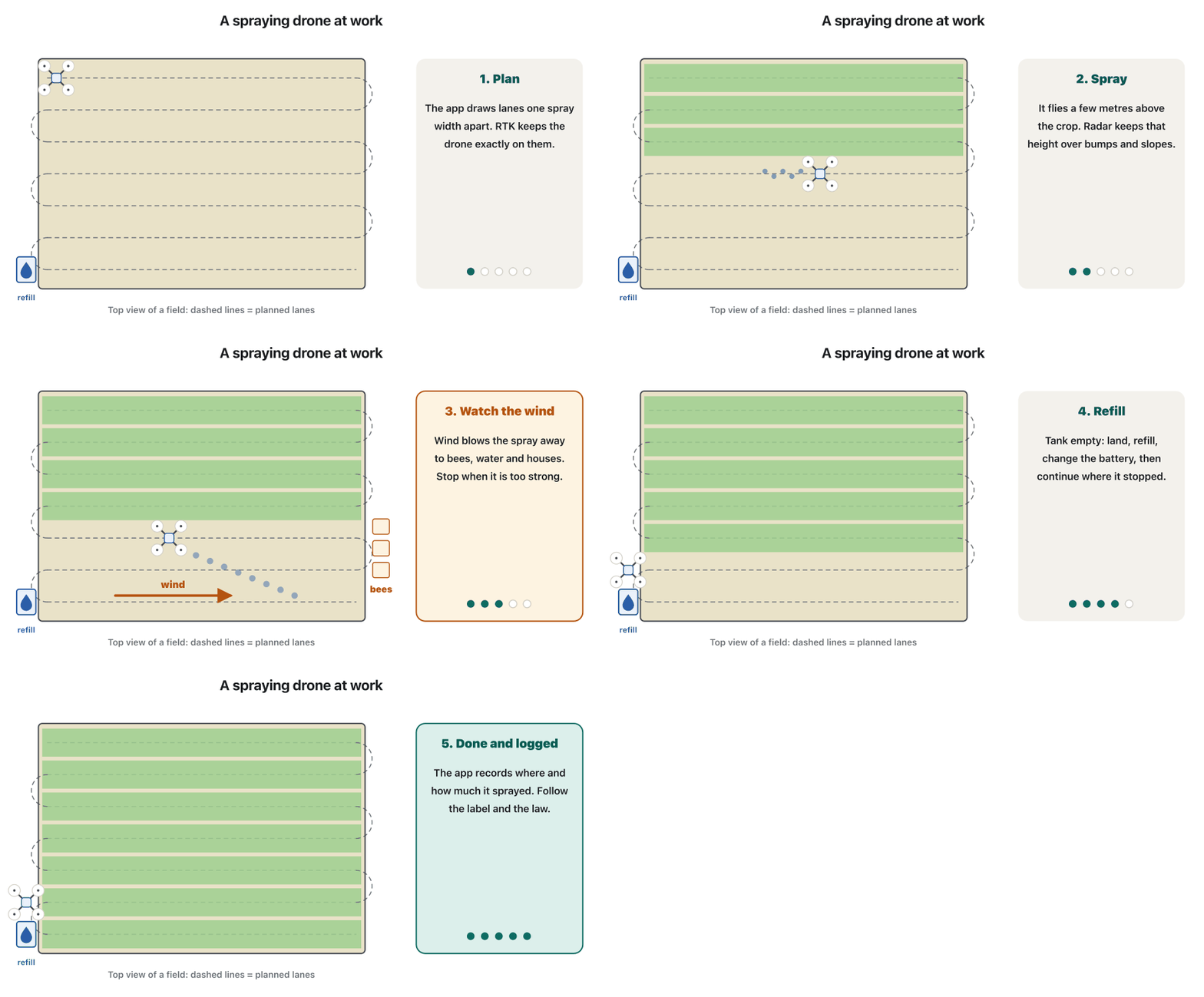
Some farm drones do more than look: they spray. A is a large multirotor with a tank, a pump and nozzles. It flies planned lanes a few metres above the crop, kept on its line by and at the right height by a downward-looking radar. It reaches hillside vineyards and wet fields where a tractor cannot go, and with an NDVI map it sprays only the sick patches. DJI, the biggest maker, says that more than 600,000 of its farm drones were working in over 100 countries at the end of 2025.
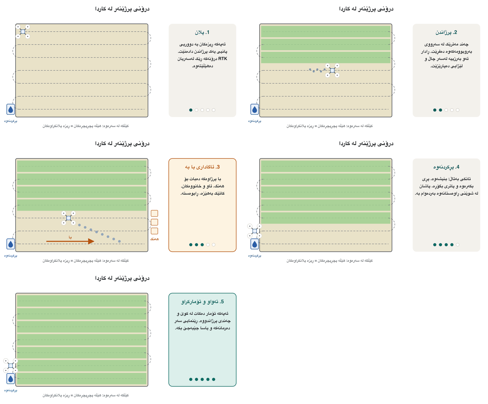
هەندێک کشتوکاڵی تەنیا سەیر ناکەن: دەپرژێنن. گەورەیە بە تانک، پەمپ و سەرەپرژێن. بە ڕیزی پلانکراو چەند مەترێک لە سەرووی بەروبوومەکەوە دەفڕێت؛ لەسەر هێڵەکەی دەیهێڵێتەوە و کە بەرەو خوار دەڕوانێت بەرزییەکەی ڕێک ڕادەگرێت. دەگاتە باخی ترێی سەر گرد و کێڵگەی تەڕ کە تراکتۆر ناتوانێت بچێتە ناویان و بە نەخشەی NDVI تەنیا پەڵە نەخۆشەکان دەپرژێنێت. DJI، گەورەترین دروستکەر، دەڵێت لە کۆتایی 2025دا زیاتر لە 600,000 کشتوکاڵیی ئەو لە زیاتر لە 100 وڵاتدا کاریان دەکرد.
Spraying from the air has stricter rules than flying a camera, because the wind can carry spray (drift) onto beehives, water, houses and people. In the USA a spray-drone company needs an agricultural aircraft operator certificate (14 CFR Part 137) and must follow the product label and the state's pesticide rules. In the EU, aerial spraying of pesticides has been banned since 2009 except by special permission; an easier route for some drone types, proposed in December 2025, was still being negotiated in November 2026. Wherever you are, ask the agriculture and aviation authorities first (Iraq and the Kurdistan Region) and stop when the wind is too strong.
پرژاندن لە ئاسمانەوە یاسای توندتری هەیە لە فڕاندنی کامێرا، چونکە با دەتوانێت پرژاوەکە ببات بۆ سەر کەندووی هەنگ، ئاو، خانوو و خەڵک. لە ئەمریکا کۆمپانیایەکی پێویستی بە بڕوانامەی کارپێکردنی فڕۆکەی کشتوکاڵی (14 CFR Part 137) هەیە و دەبێت ڕێنمایی سەر بەرهەمەکە و یاساکانی دەرمانی ویلایەتەکە جێبەجێ بکات. لە یەکێتیی ئەوروپا، پرژاندنی دەرمانی کشتوکاڵی لە ئاسمانەوە لە 2009ەوە قەدەغەیە مەگەر بە ڕێگەپێدانی تایبەت؛ ڕێگەیەکی ئاسانتر بۆ هەندێک جۆری ، کە لە کانوونی یەکەمی 2025دا پێشنیار کرا، لە تشرینی دووەمی 2026دا هێشتا گفتوگۆی لەسەر دەکرا. لە هەر شوێنێک بیت، سەرەتا لە دەزگاکانی کشتوکاڵ و فڕۆکەوانی بپرسە (عێراق و هەرێمی کوردستان) و کاتێک با بەهێزە ڕابوەستە.
Building sites (1): surveys and 3D modelsشوێنی بیناسازی (1): ڕووپێو و مۆدێلی سێ ڕەهەندی
On a building site, time is money. A drone flies a mapping pattern over the site, and turns hundreds of overlapping photos into an accurate 3D model and a photo map you can measure on (Photogrammetry: 3D from many photos). With or , it is accurate to a few centimetres (Ground control points).
لە شوێنی بیناسازیدا کات پارەیە. بە نەخشەیەکی پلانکراو بەسەر شوێنەکەدا دەفڕێت و سەدان وێنەی بەسەریەکداچوو دەکات بە مۆدێلێکی سێ ڕەهەندیی ورد و نەخشەیەکی وێنەیی کە دەتوانیت لەسەری بپێویت (فۆتۆگرامێتری: سێ ڕەهەند لە چەندین وێنە). بە یان ، وردییەکەی دەگاتە چەند سانتیمەترێک (خاڵەکانی کۆنترۆڵی زەمینی).
Example: a company building flats in Sulaymaniyah flies the same mission every Monday. Engineers compare each week's model with the plan: Is the foundation the right size? How much earth has been moved? How big is the gravel pile? To measure a pile, software splits the model into tiny squares, multiplies each square's area by its height and adds them up. In one study, drone volumes were within 4 % of a laser scan.
نموونە: کۆمپانیایەک کە لە سلێمانی شوقە دروست دەکات هەموو دووشەممەیەک هەمان فڕین دووپاتە دەکاتەوە. ئەندازیاران مۆدێلی هەر هەفتەیەک لەگەڵ پلانەکەدا بەراورد دەکەن: ئایا بناغەکە قەبارەی دروستە؟ چەند خۆڵ گوازراوەتەوە؟ کۆمەڵە چەوەکە چەندە گەورەیە؟ بۆ پێوانی کۆمەڵەیەک، مۆدێلەکە دابەش دەکات بۆ چوارگۆشەی زۆر بچووک، ڕووبەری هەر چوارگۆشەیەک لە بەرزییەکەی دەدات و هەموویان کۆ دەکاتەوە. لە توێژینەوەیەکدا جیاوازیی قەبارەکانی لەگەڵ پێوانی لەیزەری کەمتر لە 4 % بوو.
Building sites (2): safety and inspectionشوێنی بیناسازی (2): سەلامەتی و پشکنین
Drones also make big sites safer. A short flight shows the whole site from above: a deep trench with no fence, a blocked emergency exit, materials stacked too close to an edge. Managers see the problem early, without walking into danger.
شوێنە گەورەکانیش سەلامەتتر دەکەن. فڕینێکی کورت هەموو شوێنەکە لە سەرەوە پیشان دەدات: چاڵێکی قووڵ بەبێ پەرژین، دەرگای فریاکەوتنی داخراو، کەرەستە کە زۆر نزیک لە لێوارێک کەڵەکە کراون. بەڕێوەبەران کێشەکە زوو دەبینن، بەبێ ئەوەی بچنە ناو مەترسییەوە.
The same idea, , is used on structures that are dangerous to climb: roofs, chimneys, bridges, power lines and towers, wind turbines and solar farms. A zoom camera finds cracks and rust; a finds hot electrical joints and faulty solar cells (Thermal cameras). Keep your distance: steel and power lines can disturb the compass and the radio link. The drone collects the pictures; an engineer still decides what they mean.
هەمان بیرۆکە، ، بۆ ئەو بینایانە بەکاردێت کە سەرکەوتن بەسەریاندا مەترسیدارە: سەربان، دووکەڵکێش، پرد، هێڵ و تاوەری کارەبا، تووربینی با و وێستگەی خۆر. کامێرای زووم درز و ژەنگ دەدۆزێتەوە؛ جومگەی کارەبایی گەرم و خانەی خراپی پانێڵی خۆر دەدۆزێتەوە (کامێرا گەرمییەکان). دووری بپارێزە: ئاسن و هێڵی کارەبا دەتوانن قیبلەنما و پەیوەندیی ڕادیۆیی تێک بدەن. وێنەکان کۆ دەکاتەوە؛ ئەندازیار هێشتا بڕیار دەدات واتایان چییە.
Checking bridges, power lines, towers, roofs, wind turbines or pipelines with a instead of climbing them: the drone takes close-up photos, video or pictures that experts study.
پشکنینی پرد، هێڵی کارەبا، تاوەر، سەربان، تووربینی با یان بۆرییە بە لە جیاتی سەرکەوتن بەسەریاندا: وێنە، ڤیدیۆ یان وێنەی لە نزیکەوە دەگرێت و پسپۆڕان لێی دەکۆڵنەوە.
Fighting firesئاگرکوژاندنەوە
In a wildfire, smoke hides the fire from people and from ordinary cameras. A sees heat, and its long-wave infrared passes through smoke far better than visible light. So a drone can map the fire edge and find hotspots: small hidden fires that can start the fire again. Heat maps are often made at night, when hot ground stands out most against the cool land. On the ground, IoT smoke sensors can raise the first alarm (Fires on the mountains).
لە ئاگری دارستاندا دووکەڵ ئاگرەکە لە خەڵک و لە کامێرای ئاسایی دەشارێتەوە. تیشکی گەرمی دەبینێت و ئەو شەپۆل درێژەی بەکاری دەهێنێت زۆر باشتر لە ڕووناکیی بینراو بە ناو دووکەڵدا تێدەپەڕێت. بۆیە دەتوانێت نەخشەی لێواری ئاگر بکێشێت و شوێنە گەرمەکان بدۆزێتەوە: ئاگری بچووکی شاراوە کە دەتوانن ئاگرەکە دووپاتە هەڵبگیرسێننەوە. نەخشەی گەرمی زۆرجار لە شەودا دروست دەکرێت، کاتێک زەویی گەرم لە ناو زەویی ساردا زیاتر دیار دەبێت. لەسەر زەویش دووکەڵی IoT دەتوانن یەکەم ئاگادارکردنەوە بدەن (ئاگر لە شاخ: بۆنکردنی دووکەڵ بە هەستەوەر).
Firefighters use the map to decide where to send crews and water. But a private drone near a fire is dangerous: helicopters and water-bombing planes must stop until it leaves, and meanwhile the fire grows. US forest services put it simply: “If you fly, we can't.” Leave fire flights to the fire service.
ئاگرکوژێنەوەکان نەخشەکە بەکار دەهێنن بۆ ئەوەی بڕیار بدەن تیم و ئاو بۆ کوێ بنێرن. بەڵام تایبەت لە نزیک ئاگر مەترسیدارە: هەلیکۆپتەر و فڕۆکەکانی ئاوڕشتن دەبێت ڕابوەستن تا ئەو دەڕوات و لەو ماوەیەدا ئاگرەکە گەورەتر دەبێت. دەزگاکانی دارستانی ئەمریکا بە سادەیی دەڵێن: «ئەگەر تۆ بفڕیت، ئێمە ناتوانین.» فڕین بۆ ئاگر بۆ دەزگای ئاگرکوژاندنەوە جێبهێڵە.
Searching the mountainsگەڕان و ڕزگارکردن لە شاخدا
teams use drones to search large, steep places quickly. Imagine a hiker lost at night on Mount Halgurd. The drone flies lanes that overlap a little, so no strip is missed, and its thermal camera shows every warm spot. People check each one, because a warm rock or a goat can look like a person (A warm spot is not always a person). How AI helps rescuers sort the pictures is taught in Finding people after a disaster.
تیمەکانی بەکار دەهێنن بۆ ئەوەی بە خێرایی لە شوێنی گەورە و لێژدا بگەڕێن. وای دابنێ شاخەوانێک بە شەو لە چیای هەڵگورد ون بووە. بە چەند ڕیزێک دەفڕێت کە کەمێک بەسەریەکدا دەچن تا هیچ شریتێک بەجێ نەمێنێت و هەموو شوێنێکی گەرم پیشان دەدات. مرۆڤ هەر یەکێکیان دەپشکنێت، چونکە بەردێکی گەرم یان بزنێک دەکرێت لە مرۆڤ بچێت (شوێنێکی گەرم هەمیشە مرۆڤ نییە). ئەوەی چۆن یارمەتی ڕزگارکەران دەدات بۆ ڕیزکردنی وێنەکان، لە وانەی دۆزینەوەی خەڵک دوای کارەسات فێر دەکرێت.
Snow is different. After an avalanche, a thermal camera cannot see a person under deep snow. Buried people are found with avalanche beacons (transceivers), probes and dogs. In a Norwegian trial, a drone carrying an avalanche transceiver found buried beacons, and its camera spotted ski tracks and the edges of the avalanche. Drones can make such searches faster and keep rescuers off dangerous slopes.
بەفر جیاوازە. دوای ڕنووی بەفر، ناتوانێت مرۆڤی ژێر بەفری قووڵ ببینێت. خەڵکی ژێر بەفر بە ئامێری ئاماژەدەری ڕنوو، شیشی پشکنین و سەگ دەدۆزرێنەوە. لە تاقیکردنەوەیەکی نەرویجیدا، کە ئامێرێکی وەرگری ئاماژەی ڕنووی هەڵگرتبوو ئاماژەدەرە شاردراوەکانی دۆزییەوە و کامێراکەی شوێنی تەختەی خلیسکێن و لێوارەکانی ڕنووەکەی بینی. دەتوانن ئەم گەڕانانە خێراتر بکەن و ڕزگارکەران لە لێژایی مەترسیدار دوور بخەنەوە.
Medical deliveries: Rwanda, 2016گەیاندنی پزیشکی: ڕواندا، 2016
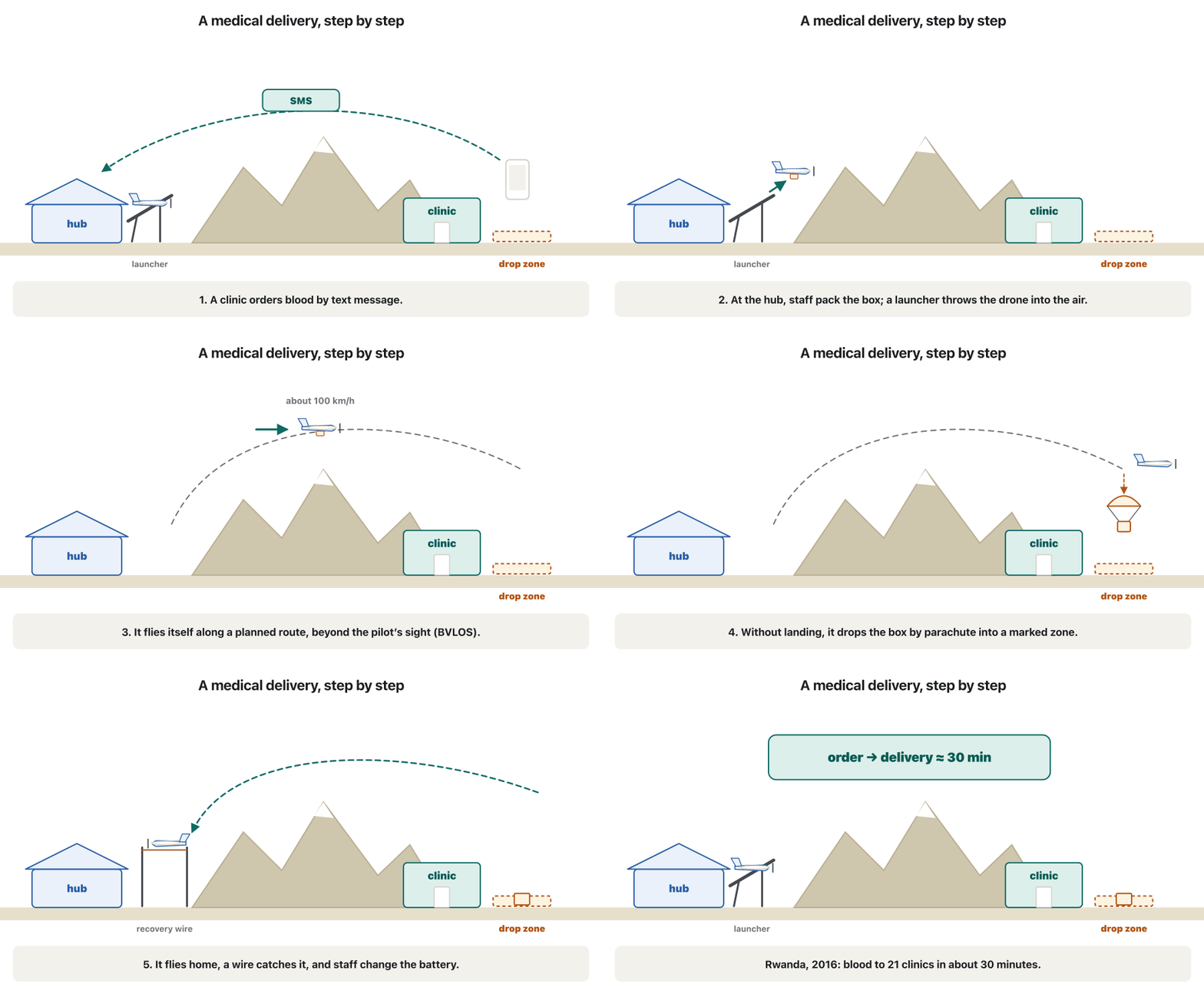
Roads to remote clinics can be long, broken or blocked, and some supplies cannot wait: a mother bleeding after childbirth needs blood now. On 14 October 2016 Rwanda launched the world's first national service, run by the company Zipline. Clinics ordered blood by text message. A small carried up to 1.5 kg, flew up to 150 km there and back, and dropped the box by parachute near the clinic, about 30 minutes after the order.
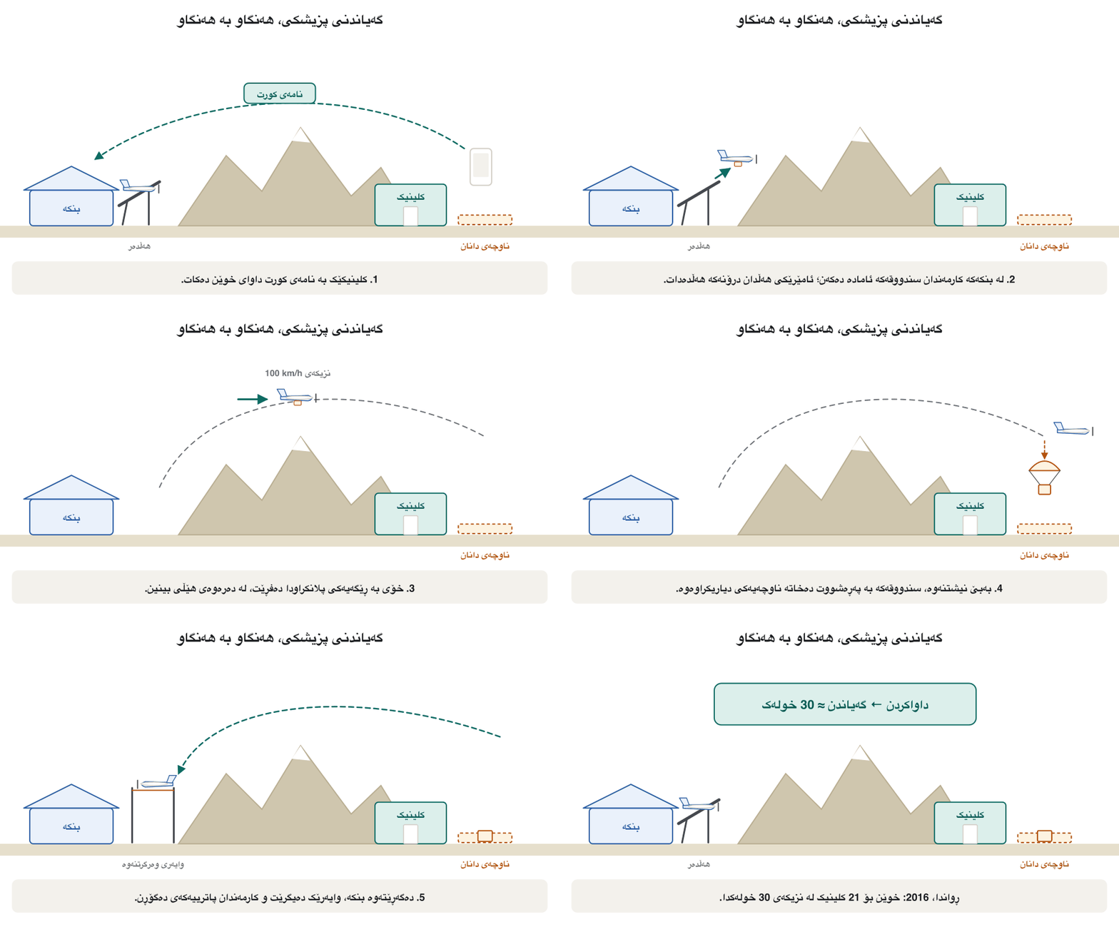
ڕێگای کلینیکە دوورەدەستەکان دەکرێت درێژ، تێکشکاو یان داخراو بن و هەندێک پێداویستی چاوەڕێ ناکات: دایکێک کە دوای منداڵبوون خوێنی لێ دەڕوات ئێستا خوێنی پێویستە. لە 14ی تشرینی یەکەمی 2016دا ڕواندا یەکەم خزمەتگوزاریی نیشتیمانیی لە جیهاندا دەست پێ کرد کە کۆمپانیای Zipline بەڕێوەی دەبرد. کلینیکەکان بە داوای خوێنیان دەکرد. بچووک تا 1.5 kg هەڵدەگرت، تا 150 km چوون و هاتن دەفڕی و سندووقەکەی بە پەڕەشووت لە نزیک کلینیکەکە فڕێ دەدا، نزیکەی 30 خولەک دوای داواکردن.
The idea spread. Ghana's service began on 24 April 2019, and Zipline later flew in more countries in Africa and in the USA; in July 2026 the company reported more than 2.5 million commercial deliveries (a company figure). For aid after disasters, see Delivering food and medicine. Here is one delivery, step by step:
بیرۆکەکە بڵاو بووەوە. خزمەتگوزارییەکەی غانا لە 24ی نیسانی 2019دا دەستی پێ کرد و دواتر Zipline لە وڵاتی تری ئەفریقا و لە ئەمریکاش فڕی؛ لە تەممووزی 2026دا کۆمپانیاکە ڕایگەیاند کە زیاتر لە 2.5 ملیۆن گەیاندنی بازرگانیی ئەنجام داوە (ژمارەی کۆمپانیاکە). بۆ یارمەتیدان دوای کارەسات، بڕوانە گەیاندنی خۆراک و دەرمان. ئەمە گەیاندنێکە، هەنگاو بە هەنگاو:
Carrying small parcels, food or medicine by , usually . In 2016 Rwanda began the world's first national drone delivery of blood to clinics; the parcel is dropped by parachute or lowered over a marked spot.
گواستنەوەی پاکەتی بچووک، خواردن یان دەرمانە بە ، زۆرجار بە . لە 2016دا ڕواندا یەکەم خزمەتگوزاریی نیشتیمانیی گەیاندنی خوێنی بە بۆ کلینیکەکان دەست پێ کرد؛ پاکەتەکە بە پەڕەشووت فڕێ دەدرێت یان بەسەر شوێنێکی دیاریکراودا دادەبەزێنرێت.
Medical deliveries: Rwanda, 2016گەیاندنی پزیشکی: ڕواندا، 2016
Bringing the parcel downدابەزاندنی پاکەتەکە
A delivery drone must put the parcel down without hurting anyone. There are three main ways. Parachute: Zipline's first drones release the box from about 20 m into a zone about as big as two parking spaces. Tether: Wing's drones hover about 7 m up and lower the parcel on a line, and Zipline's newer system lowers a small robot from up to about 90 m. Landing: the drone lands on a pad, leaves the parcel and takes off again; Matternet, whose M2 hospital drone holds a US type certificate, began regular flights between hospital sites in central London in 2026.
گەیاندن دەبێت پاکەتەکە دابنێت بەبێ ئەوەی زیان بە کەس بگەیەنێت. سێ ڕێگەی سەرەکی هەیە. پەڕەشووت: یەکەم Zipline سندووقەکە لە بەرزیی نزیکەی 20 m بەر دەدەن بۆ ناوچەیەک کە نزیکەی دوو شوێنی ڕاگرتنی ئۆتۆمبێلە. پەت: Wing لە بەرزیی نزیکەی 7 m ڕادەوەستن و پاکەتەکە بە پەتێک دادەبەزێنن و سیستەمە نوێیەکەی Zipline بچووک لە بەرزیی تا نزیکەی 90 m دادەبەزێنێت. نیشتنەوە: لەسەر شوێنی نیشتنەوە دادەنیشێت، پاکەتەکە بەجێ دەهێڵێت و دووپاتە هەڵدەفڕێت؛ M2ـی Matternet بۆ نەخۆشخانەکان ئەمریکیی هەیە و لە 2026دا فڕینی ڕێکوپێکی لە نێوان بنکەکانی نەخۆشخانە لە ناوەڕاستی لەندەن دەست پێ کرد.
In 2026 Wing (working with Walmart), Zipline and Amazon Prime Air (with its MK30 drone) were opening home-delivery sites in many US cities, mostly for small shop orders of a few kilograms at most.
لە 2026دا Wing (لەگەڵ Walmart)، Zipline و Amazon Prime Air (بە MK30) شوێنی گەیاندن بۆ ماڵیان لە زۆر شاری ئەمریکا دەکردەوە، زۆربەی بۆ داواکاریی بچووکی فرۆشگا کە زۆرترین چەند کیلۆیەکن.
When does drone delivery make sense?گەیاندن بە درۆن کەی گونجاوە؟
Drone delivery is not magic. It fits light, urgent parcels on difficult routes, in calm weather, with permission to fly beyond the pilot's sight (: see BVLOS: out of sight and BVLOS and the Part 108 rule) and a safe place to drop. Heavy or bulky goods, strong wind, rain and ice, crowds below and the noise that neighbours dislike are its limits, and cameras over gardens raise questions (Privacy: what a drone camera can see).
جادوو نییە. بۆ پاکەتی سووک و پەلە لە ڕێگای سەخت، لە کەشی هێمن، بە مۆڵەتی فڕین لە دەرەوەی بینینی فڕۆکەوان (: بڕوانە فڕینی BVLOS و BVLOS و یاسای Part 108) و شوێنێکی سەلامەتی دانان گونجاوە. کاڵای قورس یان گەورە، بای بەهێز، باران و سەهۆڵ، قەرەباڵغی لە خوارەوە و ئەو دەنگەی دراوسێکان پێی بێزارن سنوورەکانین و کامێرا لە سەرووی باخچەکانەوە پرسیاری دروست دەکات (تایبەتێتی: کامێرای درۆن چی دەبینێت).
Is it greener? That depends on the whole trip's . A 2018 study in Nature Communications found that a small drone carrying a 0.5 kg parcel caused 54 % less greenhouse gas than a diesel van in California and 23 % less in Missouri, where much of the electricity comes from coal. But an 8 kg parcel on a bigger drone caused 50 % more than the van in Missouri. Multicopters can fly only about 4 km out, so delivery needs extra local warehouses, and their energy counts too.
ئایا بۆ ژینگە باشترە؟ ئەمە بەستراوەتەوە بە هەموو گەشتەکە. توێژینەوەیەکی 2018 لە گۆڤاری Nature Communications دۆزییەوە کە بچووک بە پاکەتێکی 0.5 kg لە کالیفۆرنیا 54 % و لە میسۆری 23 % گازی گەرمخانەیی کەمتری لە ئۆتۆمبێلێکی دیزڵ دەردا؛ لە میسۆری بەشێکی زۆری کارەبا لە خەڵووزەوە دێت. بەڵام پاکەتێکی 8 kg لەسەر گەورەتر لە میسۆری 50 % زیاتری لە ئۆتۆمبێلەکە دەردا. تەنیا دەتوانن نزیکەی 4 km دوور بفڕن، بۆیە گەیاندن کۆگای ناوخۆیی زیادەی پێویستە و وزەی ئەو کۆگایانەش هەژمار دەکرێت.
Media: live events, news and filmمیدیا: ڕووداوی ڕاستەوخۆ، هەواڵ و فیلم
Drones give television and film-makers views from the air that once needed a helicopter: a football match from above, a marathon through the city, a flood seen from the sky for the evening news, a smooth sweeping shot in a film. A gimbal keeps the camera steady (Cameras and gimbals), and live video reaches the broadcast van by radio or over the mobile network.
دیمەنی ئاسمان دەدەنە تەلەفزیۆن و فیلمسازان کە پێشتر هەلیکۆپتەری پێویست بوو: یارییەکی تۆپی پێ لە سەرەوە، ماراسۆنێک بە ناو شاردا، لافاوێک لە ئاسمانەوە بۆ هەواڵی ئێوارە، وێنەیەکی نەرم و فراوان لە فیلمێکدا. کامێراکە جێگیر ڕادەگرێت (کامێرا و گیمباڵەکان) و ڤیدیۆی ڕاستەوخۆ بە ڕادیۆ یان بە دەگاتە ئۆتۆمبێلی پەخش.
Events mean crowds, and a falling drone can hurt people. In the EU's open category you may never fly over a crowd, and only the smallest drones may pass over single people at all; filming a big event needs a special authorisation (The open category). In Iraq, the ICAA's drone guide asks for permission even to take photos or video from a drone (Iraq and the Kurdistan Region). Ask the organiser and the authority, keep your distance, and never film or publish people without their consent. Festival light shows are a different job: see Light shows are choreography.
ڕووداو واتە قەرەباڵغی و کە دەکەوێتە خوارەوە دەتوانێت زیان بە خەڵک بگەیەنێت. لە یەکێتیی ئەوروپادا هەرگیز ناتوانیت بەسەر قەرەباڵغیدا بفڕیت و تەنیا بچووکترین دەتوانن بەسەر تاکە کەسدا تێبپەڕن؛ وێنەگرتنی ڕووداوێکی گەورە ڕێگەپێدانی تایبەتی پێویستە (جۆری کراوە). لە عێراق، ڕێبەری عێراق (ICAA) تەنانەت بۆ گرتنی وێنە و ڤیدیۆ لە مۆڵەت داوا دەکات (عێراق و هەرێمی کوردستان). لە ڕێکخەر و دەسەڵاتداران بپرسە، دووری بپارێزە و هەرگیز بەبێ خەڵک وێنەیان مەگرە و بڵاوی مەکەرەوە. لە فێستیڤاڵەکاندا کارێکی ترن: بڕوانە نمایشی ڕووناکی ڕێکخستنی پێشوەختەیە.
Virtual tourismگەشتیاریی گریمانەیی
lets people visit a place without travelling. A drone hovers and turns, taking many overlapping photos; software stitches them into a 360° panorama, or builds a 3D model with photogrammetry. Visitors then look around on a phone or in a (Virtual reality): an in which you feel you are standing there.
ڕێگە دەدات خەڵک بەبێ گەشتکردن سەردانی شوێنێک بکەن. ڕادەوەستێت و دەسووڕێتەوە و چەندین وێنەی بەسەریەکداچوو دەگرێت؛ پێکیان دەدوورێتەوە بۆ دیمەنێکی 360 پلەیی، یان بە مۆدێلێکی سێ ڕەهەندی دروست دەکات. پاشان سەردانکەران بە یان سەیری دەوروبەر دەکەن (ڕاستیی گریمانەیی): کە هەست دەکەیت لەوێ وەستاویت.
Virtual tourismگەشتیاریی گریمانەیی
A place to try it: the Erbil Citadelشوێنێک بۆ تاقیکردنەوە: قەڵای هەولێر
Kurdistan has fine places to imagine this for. The Erbil Citadel, a UNESCO World Heritage Site since 2014, could become a 3D model that anyone in the world can walk around. Such records also protect heritage: if a wall is damaged, the model shows how it looked. Flying over heritage sites needs permission, and some are closed to drones.
کوردستان شوێنی جوانی هەیە بۆ ئەم کارە. قەڵای هەولێر، کە لە 2014ەوە یەکێکە لە شوێنەکانی میراتی جیهانیی یونسکۆ، دەکرێت ببێتە مۆدێلێکی سێ ڕەهەندی کە هەر کەسێک لە جیهاندا بتوانێت بە ناویدا بگەڕێت. ئەم تۆمارانە شوێنەواریش دەپارێزن: ئەگەر دیوارێک زیانی پێ بگات، مۆدێلەکە پیشان دەدات پێشتر چۆن بوو. فڕین بەسەر شوێنەوارە مێژووییەکاندا مۆڵەتی پێویستە و هەندێکیان بە ڕووی داخراون.
Common mistakesهەڵە باوەکان
| Mistakeهەڵە | Fixچارەسەر |
|---|---|
| Thinking an NDVI or thermal map tells you the cause.وا بزانیت نەخشەی NDVI یان گەرمی هۆکارەکەت پێ دەڵێت. | It shows where to look. Walk there and check: water, pests or soil.پیشانت دەدات بۆ کوێ بڕوانیت. بچۆ ئەوێ و بپشکنە: ئاو، مێروو یان خاک. |
| Spraying on a windy day, or without the licence.پرژاندن لە ڕۆژێکی بادار، یان بەبێ مۆڵەت. | Check the rules and the product label; stop when wind could carry spray to bees, water or houses.یاساکان و ڕێنمایی سەر بەرهەمەکە بپشکنە؛ کاتێک با دەتوانێت پرژاو بۆ هەنگ، ئاو یان خانوو ببات ڕابوەستە. |
| Flying your drone to film a fire or an accident.فڕاندنی بۆ وێنەگرتنی ئاگر یان ڕووداوێک. | Stay away: rescue and firefighting aircraft must stop when a drone is near.دوور بکەوە: فڕۆکەکانی ڕزگارکردن و ئاگرکوژاندنەوە ناچار دەبن ڕابوەستن کاتێک نزیکە. |
| Believing every warm spot is a person, and every person shows up warm.باوەڕکردن بەوەی هەموو شوێنێکی گەرم مرۆڤە و هەموو مرۆڤێک گەرم دەردەکەوێت. | People check every warm spot; a person under rubble or deep snow may not show at all.مرۆڤ هەموو شوێنێکی گەرم دەپشکنێت؛ کەسێک لە ژێر داروپەردوو یان بەفری قووڵدا لەوانەیە هەر دەرنەکەوێت. |
| Thinking drone delivery is always faster and greener.وا بزانیت هەمیشە خێراتر و بۆ ژینگە باشترە. | It suits light, urgent parcels on hard routes; check weight, weather, permission and emissions.بۆ پاکەتی سووک و پەلە لە ڕێگای سەخت گونجاوە؛ کێش، کەشوهەوا، مۆڵەت و دەردانی کاربۆن بپشکنە. |
| Flying over a crowd for a better shot.فڕین بەسەر قەرەباڵغیدا بۆ وێنەیەکی باشتر. | Never: film from the side, with permission and respect for privacy.هەرگیز: لە لاوە وێنە بگرە، بە مۆڵەت و ڕێزگرتن لە . |
Exercisesڕاهێنانەکان
For each job, choose a drone type, a payload and the main safety or legal point: (a) a crop-health map of a 50-hectare wheat field; (b) spraying a hillside vineyard; (c) checking the underside of a bridge; (d) blood for a mountain clinic 40 km away; (e) filming a football match.
بۆ هەر کارێک جۆرێکی ، و خاڵی سەرەکیی سەلامەتی یان یاسا هەڵبژێرە: (a) نەخشەی تەندروستیی بەروبووم بۆ کێڵگەیەکی گەنمی 50 هێکتاری؛ (b) پرژاندنی باخێکی ترێی سەر گرد؛ (c) پشکنینی ژێرەوەی پردێک؛ (d) خوێن بۆ کلینیکێکی شاخاوی کە 40 km دوورە؛ (e) وێنەگرتنی یارییەکی تۆپی پێ.
Show answerوەڵامەکە پیشان بدە
| Jobکار | Drone | Payload | Main pointخاڵی سەرەکی |
|---|---|---|---|
| (a) crop map(a) نەخشەی بەروبووم | fixed-wing or multirotorباڵجێگیر یان | multispectral camera | walk to the pale patches to find the causeبچۆ سەر پەڵە کاڵەکان بۆ دۆزینەوەی هۆکار |
| (b) vineyard(b) باخی ترێ | spraying drone | tank, pump, nozzlesتانک، پەمپ، سەرەپرژێن | spraying licence, label, windمۆڵەتی پرژاندن، ڕێنمایی، با |
| (c) bridge(c) پرد | small multirotor بچووک | zoom and thermal cameraکامێرای زووم و گەرمی | keep distance from steel; permission near roadsدوور لە ئاسن؛ مۆڵەت لە نزیک ڕێگا |
| (d) blood(d) خوێن | fixed-wing or VTOL delivery drone گەیاندنی باڵجێگیر یان VTOL | box with parachute or tetherسندووق بە پەڕەشووت یان پەت | BVLOS approval, safe drop zoneمۆڵەتی BVLOS، شوێنی دانانی سەلامەت |
| (e) football match(e) یاریی تۆپی پێ | camera multirotor کامێرا | gimbal cameraکامێرای سەر | never over the crowd; permission; privacyهەرگیز بەسەر قەرەباڵغیدا نا؛ مۆڵەت؛ |
A gravel pile is measured on 2 m × 2 m cells. Six cells have heights 0.5, 1.0, 2.0, 1.5, 1.0 and 0.5 m; all other cells are 0. Estimate the volume.
کۆمەڵە چەوێک لەسەر خانەی 2 m × 2 m دەپێورێت. شەش خانە بەرزییان 0.5، 1.0، 2.0، 1.5، 1.0 و 0.5 مەترە؛ خانەکانی تر سفرن. قەبارەکەی بخەمڵێنە.
Hintئاماژە
Volume = sum of heights × area of one cell.
قەبارە = کۆی بەرزییەکان × ڕووبەری یەک خانە.
Show answerوەڵامەکە پیشان بدە
About 26 m³: add the heights, then multiply by the area of one cell (4 m²).
نزیکەی 26 m³: بەرزییەکان کۆ بکەرەوە، پاشان لە ڕووبەری یەک خانە (4 m²) بیدە.
In winter, a mother in a mountain village near Penjwen is bleeding after giving birth, and the clinic needs blood. The road takes two hours when it is open. Write four questions you must answer before sending a drone.
لە زستاندا، دایکێک لە گوندێکی شاخاوی نزیک پێنجوێن دوای منداڵبوون خوێنی لێ دەڕوات و کلینیکەکە خوێنی پێویستە. ڕێگاکە کاتێک کراوەیە دوو کاتژمێر دەخایەنێت. چوار پرسیار بنووسە کە پێش ناردنی دەبێت وەڵامیان بدەیتەوە.
Show answerوەڵامەکە پیشان بدە
- Is the parcel light and small enough, and does the blood stay cold enough?
- Is the weather safe: wind, snow, icing, and batteries that lose power in the cold?
- Do we have permission to fly beyond sight, and is the airspace clear?
- Is there a safe drop zone and someone to receive the box?
- Can the drone fly there and back, and what is the backup plan (road, helicopter)?
- ئایا پاکەتەکە بەس سووک و بچووکە و خوێنەکە بەس سارد دەمێنێتەوە؟
- ئایا کەشوهەوا سەلامەتە: با، بەفر، سەهۆڵبەستن و کە لە سەرمادا وزەی کەم دەبێتەوە؟
- ئایا مۆڵەتی فڕینی دەرەوەی بینینمان هەیە و چۆڵە؟
- ئایا شوێنێکی سەلامەتی دانان و کەسێک بۆ وەرگرتنی سندووقەکە هەیە؟
- ئایا دەتوانێت بچێت و بگەڕێتەوە و پلانی یەدەگ چییە (ڕێگا، هەلیکۆپتەر)؟
Which map would you use first, NDVI or thermal? (a) wheat attacked by insects; (b) a leaking irrigation pipe; (c) a lost person at night; (d) which parts of a field have grown well.
سەرەتا کام نەخشە بەکار دەهێنیت، NDVI یان گەرمی؟ (a) گەنمێک کە مێروو هێرشی کردووەتە سەری؛ (b) بۆرییەکی ئاودێریی دزەکردوو؛ (c) کەسێکی ونبوو لە شەودا؛ (d) کام بەشی کێڵگەیەک باش گەشەی کردووە.
Show answerوەڵامەکە پیشان بدە
(a) NDVI: the stressed patch shows up, then walk there. (b) Thermal: a cold, wet spot. (c) Thermal: body heat at night. (d) NDVI: dense, healthy plants score high.
(a) NDVI: پەڵە ماندووەکە دەردەکەوێت، پاشان بچۆ ئەوێ. (b) گەرمی: شوێنێکی سارد و تەڕ. (c) گەرمی: گەرمیی لەش لە شەودا. (d) NDVI: ڕووەکی چڕ و تەندروست نمرەی بەرز وەردەگرێت.
Using the 2018 study, explain in two or three sentences why replacing every delivery van with drones would not automatically cut emissions.
بە پشتبەستن بە توێژینەوەکەی 2018، لە دوو یان سێ ڕستەدا ڕوون بکەرەوە بۆچی گۆڕینی هەموو ئۆتۆمبێلێکی گەیاندن بە خۆبەخۆ دەردانی کاربۆن کەم ناکاتەوە.
Show answerوەڵامەکە پیشان بدە
Small drones with light parcels emitted less than a diesel van, but heavy parcels on bigger drones could emit more, especially where electricity comes from coal. Drones also need extra local warehouses because their range is short. So the result depends on the parcel's weight, the drone's size, the electricity and the warehouses.
بچووک بە پاکەتی سووک لە ئۆتۆمبێلی دیزڵ کەمتریان دەردا، بەڵام پاکەتی قورس لەسەر گەورەتر دەکرێت زیاتر دەربدەن، بەتایبەتی لە شوێنێک کە کارەبا لە خەڵووزەوە دێت. کۆگای ناوخۆیی زیادەشیان پێویستە، چونکە ناتوانن زۆر دوور بفڕن. بۆیە ئەنجامەکە بەستراوەتەوە بە کێشی پاکەت، قەبارەی ، کارەبا و کۆگاکان.
Summaryپوختە
- Drones work on farms and building sites, in emergencies, media and delivery; the job decides the payload, the software and the permission.
- Precision agriculture: NDVI and thermal maps show where to look; walk there to find why, and act only where needed.
- Spraying drones fly planned lanes with RTK and radar; spraying from the air has strict rules because of drift.
- Photogrammetry gives 3D models and volumes of building sites; drone inspection checks roofs, bridges and power lines without climbing.
- Thermal cameras find fire edges, hotspots and lost people at night; never fly near a fire; under deep snow, beacons are needed.
- Rwanda began national drone delivery of blood on 14 October 2016; parcels come down by parachute, tether or landing.
- Delivery fits light, urgent parcels on hard routes; emissions are lower for small drones with light parcels, not always.
- Media and virtual tourism: never fly over crowds, ask permission, respect privacy; 3D records help protect heritage.
- لە کێڵگە و شوێنی بیناسازی، لە فریاکەوتن، میدیا و گەیاندندا کار دەکەن؛ کارەکە ، و مۆڵەتەکە دیاری دەکات.
- : نەخشەی NDVI و گەرمی پیشان دەدەن بۆ کوێ بڕوانیت؛ بچۆ ئەوێ بۆ ئەوەی بزانیت بۆچی و تەنیا لە شوێنی پێویست کار بکە.
- بە و بە ڕیزی پلانکراو دەفڕن؛ پرژاندن لە ئاسمانەوە بە هۆی بردنی پرژاو بە با یاسای توندی هەیە.
- مۆدێلی سێ ڕەهەندی و قەبارەی شوێنی بیناسازی دەدات؛ سەربان، پرد و هێڵی کارەبا بەبێ سەرکەوتن دەپشکنێت.
- لێواری ئاگر، شوێنی گەرم و کەسی ونبوو لە شەودا دەدۆزنەوە؛ هەرگیز لە نزیک ئاگر مەفڕە؛ لە ژێر بەفری قووڵدا ئامێری ئاماژەدەر پێویستە.
- ڕواندا لە 14ی تشرینی یەکەمی 2016دا یەکەم خزمەتگوزاریی نیشتیمانیی بۆ خوێن دەست پێ کرد؛ پاکەت بە پەڕەشووت، پەت یان نیشتنەوە دادەبەزێت.
- گەیاندن بۆ پاکەتی سووک و پەلە لە ڕێگای سەخت گونجاوە؛ دەردانی کاربۆن بۆ بچووک بە پاکەتی سووک کەمترە، نەک هەمیشە.
- میدیا و : هەرگیز بەسەر قەرەباڵغیدا مەفڕە، مۆڵەت وەربگرە، ڕێز لە بگرە؛ تۆماری سێ ڕەهەندی یارمەتی پاراستنی شوێنەوار دەدات.
Why must a farmer still walk to a pale patch on an NDVI map?بۆچی جووتیار هێشتا دەبێت بچێتە سەر پەڵەیەکی کاڵی نەخشەی NDVI؟
The map shows that plants are stressed, not why. Dry soil, pests and too little fertiliser can look the same from the air.
نەخشەکە پیشان دەدات ڕووەکەکان ماندوون، نەک بۆچی. خاکی وشک، مێروو و پەینی کەم دەکرێت لە ئاسمانەوە وەک یەک دەربکەون.
What did Rwanda's 2016 drone service deliver, and how?خزمەتگوزارییەکەی ڕواندا لە 2016دا چی دەگەیاند و چۆن؟
Blood for clinics, ordered by text message: a small fixed-wing drone carried up to 1.5 kg and dropped it by parachute, about 30 minutes after the order.
خوێن بۆ کلینیکەکان کە بە داوا دەکرا: بچووک تا 1.5 kg هەڵدەگرت و بە پەڕەشووت فڕێی دەدا، نزیکەی 30 خولەک دوای داواکردن.
Why is a private drone near a wildfire dangerous?بۆچی درۆنێکی تایبەت لە نزیک ئاگری دارستان مەترسیدارە؟
Firefighting helicopters and planes must stop flying until it leaves, so the fire grows.
هەلیکۆپتەر و فڕۆکەکانی ئاگرکوژاندنەوە ناچار دەبن فڕین ڕابگرن تا ئەو دەڕوات، بۆیە ئاگرەکە گەورە دەبێت.
Lesson complete!وانەکە تەواو بوو!
Well done. Review the key terms, then go on to the next lesson.دەستخۆش. سەیرێکی زاراوە سەرەکییەکان بکەرەوە، پاشان بڕۆ بۆ وانەی داهاتوو.
Key termsزاراوە سەرەکییەکان
Autonomy, Swarms, Air Taxis and the Future of Dronesسەربەخۆیی، ڕەوەکانی درۆن، تەکسییە ئاسمانییەکان و داهاتووی درۆنەکان
Related lecturesوانە پەیوەندیدارەکان
- Autonomy, Swarms, Air Taxis and the Future of Dronesسەربەخۆیی، ڕەوەکانی درۆن، تەکسییە ئاسمانییەکان و داهاتووی درۆنەکان
- Drone Rules in 2026: ICAO, the USA, Europe and Your Countryیاساکانی درۆن لە 2026دا: ICAO، ئەمریکا، ئەورووپا و وڵاتی خۆت
- Privacy, Security and Counter-Drone Systemsتایبەتێتی، ئاسایش و تەکنەلۆجیای دژەدرۆن
- Types of Drones: Multirotors, Fixed Wings, Helicopters and VTOLجۆرەکانی درۆن: فرەپەروانە، درۆنی باڵجێگیر، هەلیکۆپتەری بێفڕۆکەوان و VTOL
- AI That Protects: Rescue, Relief and Peacekeepingژیریی دەستکرد بۆ پاراستن: ڕزگارکردن، فریاگوزاری و ئاشتیپارێزی
- Emerging Technologies: IoT, VR/AR, Robots and Blockchainتەکنەلۆجیا نوێیەکان: ئینتەرنێتی شتەکان، ڕاستیی گریمانەیی/ڕاستیی زیادکراو، ڕۆبۆتەکان و بلۆکچەین
- Where IoT Is Used, and What Makes It HardIoT لە کوێ بەکار دێت و چی قورسی دەکات
References and further readingسەرچاوەکان و خوێندنەوەی زیاتر
- FAO and ITU: E-agriculture in action: Drones for agriculture (2018)
- DroneXL: DJI agricultural drone fleet passes 600,000 as the EU moves to ease its aerial-spray ban (30 April 2026)
- Eunews: EU Council agrees its position on simplifying pesticide rules and drone use (27 May 2026)
- 14 CFR 137.11: Agricultural aircraft operator certificate required (LII)
- Kokamägi, Türk and Liba (2020): UAV photogrammetry for volume calculations, Agronomy Research 18(3)
- Texas A&M Forest Service: Drones slow wildfire response and ground firefighting aircraft
- Abrahamsen (2014): Use of an unmanned aerial vehicle to support search and rescue operations in the mountains (avalanche trial)
- Gavi: Rwanda launches world’s first national drone delivery service powered by Zipline (14 October 2016)
- Graphic Online: medical drones start working in Ghana (24 April 2019)
- Zipline fact sheet (Platform 1 and Platform 2: payload, delivery height, drop zone)
- Zipline newsroom: Zipline Accelerates U.S. Growth with 13X Marketplace Expansion, New Leadership Hires, and Launches in Austin and Cleveland (14 July 2026; more than 2.5 million commercial deliveries)
- Wing help centre: how the package is lowered (about 23 ft, on a tether)
- CBS News: Walmart expands drone delivery with Wing to 150 more stores (January 2026)
- FreightWaves: Amazon drone delivery expansion targets 500 cities (19 August 2026)
- DroneLife: Matternet raises $33M and goes public; NHS flights in central London (28 May 2026)
- Stolaroff et al. (2018): Energy use and life cycle greenhouse gas emissions of drones for commercial package delivery, Nature Communications 9, 409
- EASA FAQ: Are spectators allowed in the open category?
- Wikipedia: Citadel of Erbil (UNESCO World Heritage Site since 21 June 2014)
This lecture is a first edition. The Kurdish text and terminology are waiting for review by Kurdish IT teachers.ئەم وانەیە چاپی یەکەمە. دەقە کوردییەکە و زاراوەکانی چاوەڕێی پێداچوونەوەی مامۆستایانی کوردی بواری IT ن.