Chapterبەش 4 · Lectureوانە 4.2
Drone Rules in 2026: ICAO, the USA, Europe and Your Countryیاساکانی درۆن لە 2026دا: ICAO، ئەمریکا، ئەورووپا و وڵاتی خۆت
Why drones need rules and the four rules almost every country shares; ICAO and national civil aviation authorities; the USA (TRUST, Part 107, Remote ID and the BVLOS rule Part 108); the EU's open, specific and certified categories, A1/A2/A3 and class marks; the UK's 2026 changes; geographical zones, NOTAMs and UTM/U-space; and what Iraq's Civil Aviation Authority has published — with the advice to check with the authorities before flying.
بۆچی یاسایان پێویستە و ئەو چوار یاسایەی نزیکەی هەموو وڵاتێک هاوبەشیانە؛ و وڵاتان؛ ئەمریکا (TRUST، Part 107، و یاسای ، Part 108)؛ ، و یەکێتیی ئەورووپا، A1/A2/A3 و ؛ گۆڕانکارییەکانی بەریتانیا لە 2026دا؛ ، و /U-space؛ و ئەوەی عێراق بڵاوی کردووەتەوە — لەگەڵ ئامۆژگاریی پشکنین لای دەسەڵاتداران پێش فڕین.
What you will learnچی فێر دەبیت
- Explain why drone rules are risk-based and name the four rules most countries share.
- Describe the roles of ICAO and of a national civil aviation authority.
- Summarise the US rules: recreational flying, Part 107, Remote ID and the status of BVLOS (Part 108).
- Place a flight in the EU's open, specific or certified category, choose A1, A2 or A3 and read a class mark.
- Check where you may fly (zones, NOTAMs, UTM) and find what Iraq's ICAA has published before flying in Iraq or the Kurdistan Region.
- ڕوونی بکەیتەوە بۆچی یاساکانی لەسەر بنەمای و ئەو چوار یاسایە ناو ببەیت کە زۆربەی وڵاتان هاوبەشیانە.
- ڕۆڵی و وڵاتێک وەسف بکەیت.
- یاساکانی ئەمریکا کورت بکەیتەوە: فڕاندنی خولیایی، Part 107، و دۆخی (Part 108).
- فڕینێک لە ، یان یەکێتیی ئەورووپادا دابنێیت، A1، A2 یان A3 هەڵبژێریت و بخوێنیتەوە.
- بپشکنیت لە کوێ دەتوانیت بفڕیت (ناوچەکان، ، ) و ئەوە بدۆزیتەوە کە ICAAـی عێراق پێش فڕین لە عێراق یان هەرێمی کوردستان بڵاوی کردووەتەوە.
Why drones need rulesبۆچی درۆنەکان یاسایان پێویستە
As drones become more popular around the world, they need many rules. A drone shares the sky with planes and helicopters, and it flies over people who never chose to be under it. Modern drone rules are risk-based: the bigger the possible harm, the more the rules ask. (You met drones briefly in Drones: robots that fly; the habits of a safe flight are in Flying safely.)
هەرچەندە لە هەموو جیهاندا باوتر دەبن، یاسای زیاتریان پێویست دەبێت. ئاسمان لەگەڵ فڕۆکە و هەلیکۆپتەر بەش دەکات و بەسەر خەڵکێکدا دەفڕێت کە هەرگیز ئەوەیان هەڵنەبژاردووە لە ژێریدا بن. یاسا نوێیەکانی لەسەر بنەمای : هەرچەندە زیانی ئەگەری گەورەتر بێت، یاساکان داوای زیاتر دەکەن. ( بە کورتی لە درۆنەکان: ڕۆبۆتی فڕیو ناسیت؛ خووەکانی فڕینی سەلامەت لە فڕینی سەلامەت هەن.)
Three questions decide the risk: how heavy is the drone, where does it fly (an empty field or a city, near an airport or not), and over whom (nobody, a few people or a crowd)? A 249 g drone over an empty field needs few rules; a 4 kg drone at the edge of a town may need permission; a heavy drone over a crowd meets the strictest rules — or may not fly there at all.
سێ پرسیار دیاری دەکەن: چەند قورسە، لە کوێ دەفڕێت (کێڵگەیەکی چۆڵ یان شارێک، لە نزیک فڕۆکەخانە یان نا) و بەسەر کێدا (هیچ کەس، چەند کەسێک یان قەرەباڵغییەک)؟ 249 گرامی بەسەر کێڵگەیەکی چۆڵدا یاسای کەمی پێویستە؛ 4 کیلۆگرامی لە لێواری شارۆچکەیەکدا لەوانەیە مۆڵەتی پێویست بێت؛ قورس بەسەر قەرەباڵغییەکدا تووشی توندترین یاسا دەبێت — یان هەر نابێت لەوێ بفڕێت.
Four rules almost every country hasچوار یاسا کە نزیکەی هەموو وڵاتێک هەیەتی
The details differ from country to country, but most countries now share four ideas:
وردەکارییەکان لە وڵاتێکەوە بۆ وڵاتێکی تر جیاوازن، بەڵام ئێستا زۆربەی وڵاتان چوار بیرۆکەیان هاوبەشە:
- Register drones above a certain weight (in some places the operator registers instead of each drone).
- Not too high: usually no more than 120 m (400 ft) above the ground.
- Not too close to airports and other no-fly zones.
- Not too close to people, and never over crowds.
- تۆمارکردنی لە سەرووی کێشێکی دیاریکراوەوە (لە هەندێک شوێن لە جیاتی هەر ، کەسی بەرپرسیار خۆی تۆمار دەکات).
- زۆر بەرز نا: زۆرجار لە 120 مەتر (400 پێ) لە سەرووی زەوییەوە بەرزتر نا.
- زۆر نزیک لە فڕۆکەخانە نا، هەروەها لە ناوچە قەدەغەکانی تری فڕین.
- زۆر نزیک لە خەڵک نا و هەرگیز بەسەر قەرەباڵغیدا نا.
The numbers differ. As of 2026, the USA asks hobby flyers to register drones over 250 g (0.55 lb); the UK asks for a Flyer ID from 100 g; the EU registers the operator rather than each drone. That is why you always check the country you fly in.
ژمارەکان جیاوازن. تا 2026، ئەمریکا داوا لە فڕۆکەوانانی خولیایی دەکات سەرووی 250 گرام (0.55 پاوەند) تۆمار بکەن؛ بەریتانیا لە 100 گرامەوە Flyer ID داوا دەکات؛ یەکێتیی ئەورووپا لە جیاتی هەر ، کەسی بەرپرسیار تۆمار دەکات. لەبەر ئەوە هەمیشە یاسای ئەو وڵاتە بپشکنە کە تێیدا دەفڕیت.
Four rules almost every country hasچوار یاسا کە نزیکەی هەموو وڵاتێک هەیەتی
Why 120 m (400 ft)?بۆچی 120 مەتر (400 پێ)؟
Why do so many countries stop drones at about 120 m? Crewed planes must normally fly higher. In US rules, for example, they keep at least 500 ft (about 150 m) above open land and 1,000 ft (about 300 m) above the highest obstacle over towns (14 CFR 91.119). Keeping drones below 120 m leaves a safety gap between the two.
بۆچی زۆر وڵات لە نزیکەی 120 مەتردا ڕادەگرن؟ فڕۆکە فڕۆکەواندارەکان بە ئاسایی دەبێت بەرزتر بفڕن. بۆ نموونە لە یاساکانی ئەمریکادا لانیکەم 500 پێ (نزیکەی 150 مەتر) لە سەرووی زەوی کراوەوە و 1,000 پێ (نزیکەی 300 مەتر) لە سەرووی بەرزترین بەربەستەوە بەسەر شارەکاندا دەمێننەوە (14 CFR 91.119). ڕاگرتنی لە خوار 120 مەترەوە بۆشاییەکی سەلامەتی لە نێوانیاندا دەهێڵێتەوە.
The gap is not perfect: helicopters may fly lower, and planes are much lower near airports when they take off and land. That is one more reason why airports are no-fly zones for drones.
بۆشاییەکە تەواو نییە: هەلیکۆپتەر دەتوانێت نزمتر بفڕێت و فڕۆکەکان لە نزیک فڕۆکەخانە کاتی هەڵفڕین و نیشتنەوە زۆر نزمترن. ئەمە هۆکارێکی ترە بۆ ئەوەی فڕۆکەخانەکان ناوچەی قەدەغەی فڕینی بن.
ICAO and the countriesICAO و وڵاتان
Who writes these rules? At world level, ICAO (the International Civil Aviation Organization), a UN agency in Montreal, sets standards for civil aviation. For drones it publishes Model UAS Regulations: a template that countries can adopt or adapt, with Part 101 for low-risk open-category flights, Part 102 for the specific category (authorisations and operator certificates) and Part 149 for approved organisations that act for the authority.
کێ ئەم یاسایانە دەنووسێت؟ لە ئاستی جیهاندا (ڕێکخراوی نێودەوڵەتیی فڕۆکەوانیی مەدەنی)، کە دەزگایەکی نەتەوە یەکگرتووەکانە لە مۆنتریال، ستاندارد بۆ فڕۆکەوانیی مەدەنی دادەنێت. بۆ یاسای نموونەیی UAS بڵاو دەکاتەوە: قاڵبێک کە وڵاتان دەتوانن وەری بگرن یان بیگونجێنن، بە Part 101 بۆ فڕینی کە کەمە، Part 102 بۆ (ڕێگەپێدان و بڕوانامەی کەسی بەرپرسیار) و Part 149 بۆ ئەو دامەزراوە پەسەندکراوانەی لە جیاتی دەسەڵاتەکە کار دەکەن.
ICAO's templates are not law by themselves. Each country turns them into its own law, and its civil aviation authority writes and enforces the rules: the FAA in the USA, EASA together with the national authorities in the EU, the CAA in the UK and the ICAA in Iraq. These rules are for civil aviation; military drones fall under other rules, including the laws of war (War has rules).
قاڵبەکانی بە خۆیان یاسا نین. هەر وڵاتێک دەیانکاتە یاسای خۆی و یاساکان دەنووسێت و جێبەجێیان دەکات: FAA لە ئەمریکا، EASA لەگەڵ دەسەڵاتە نیشتیمانییەکان لە یەکێتیی ئەورووپا، CAA لە بەریتانیا و ICAA لە عێراق. ئەم یاسایانە بۆ فڕۆکەوانیی مەدەنین؛ سەربازییەکان سەر بە یاسای ترن، لەوانە یاساکانی جەنگ (جەنگ یاسای هەیە).
The USA (1): hobby flyers and Part 107ئەمریکا (1): فڕۆکەوانانی خولیایی و Part 107
In the USA the FAA has two paths. Recreational flyers follow a safety code, pass the free online TRUST test, keep the drone in sight (or use an observer standing next to them), stay at or below 400 ft in uncontrolled airspace, ask permission for controlled airspace near airports, and register any drone over 0.55 lb (250 g).
لە ئەمریکادا FAA دوو ڕێگای هەیە. فڕۆکەوانانی خولیایی یاسایەکی سەلامەتی جێبەجێ دەکەن، تاقیکردنەوەی ئۆنلاینی بێبەرانبەری TRUST دەبڕن، لە بەرچاو دەهێڵنەوە (یان بەکار دەهێنن کە لە تەنیشتیانەوە وەستاوە)، لە کۆنترۆڵنەکراودا لە 400 پێ بەرزتر نابن، بۆ کۆنترۆڵکراو لە نزیک فڕۆکەخانەکان مۆڵەت وەردەگرن و هەر لە 0.55 پاوەند (250 گرام) قورستر بێت تۆماری دەکەن.
Everyone else — for example anyone flying for work — uses Part 107. For commercial drone operations you need to be a certified pilot: a remote pilot certificate (age 16 or over, an FAA knowledge test). The drone must be registered whatever its weight, and the limits on the card apply. Waivers can lift some limits for a named operator.
هەموو کەسێکی تر — بۆ نموونە هەر کەسێک بۆ کار دەفڕێنێت — Part 107 بەکار دەهێنێت. بۆ کاری بازرگانیی دەبێت فڕۆکەوانێکی بڕوانامەدار بیت: (تەمەنی 16 ساڵ یان زیاتر، تاقیکردنەوەی زانیاریی FAA). دەبێت تۆمار بکرێت هەر کێشێکی هەبێت و سنوورەکانی ناو کارتەکە جێبەجێ دەبن. ڕێگەپێدانی تایبەت (waiver) دەتوانێت هەندێک سنوور بۆ کەسێکی دیاریکراو لاببات.
The USA (1): hobby flyers and Part 107ئەمریکا (1): فڕۆکەوانانی خولیایی و Part 107
The USA (2): Remote IDئەمریکا (2): ناسینەوەی دوور
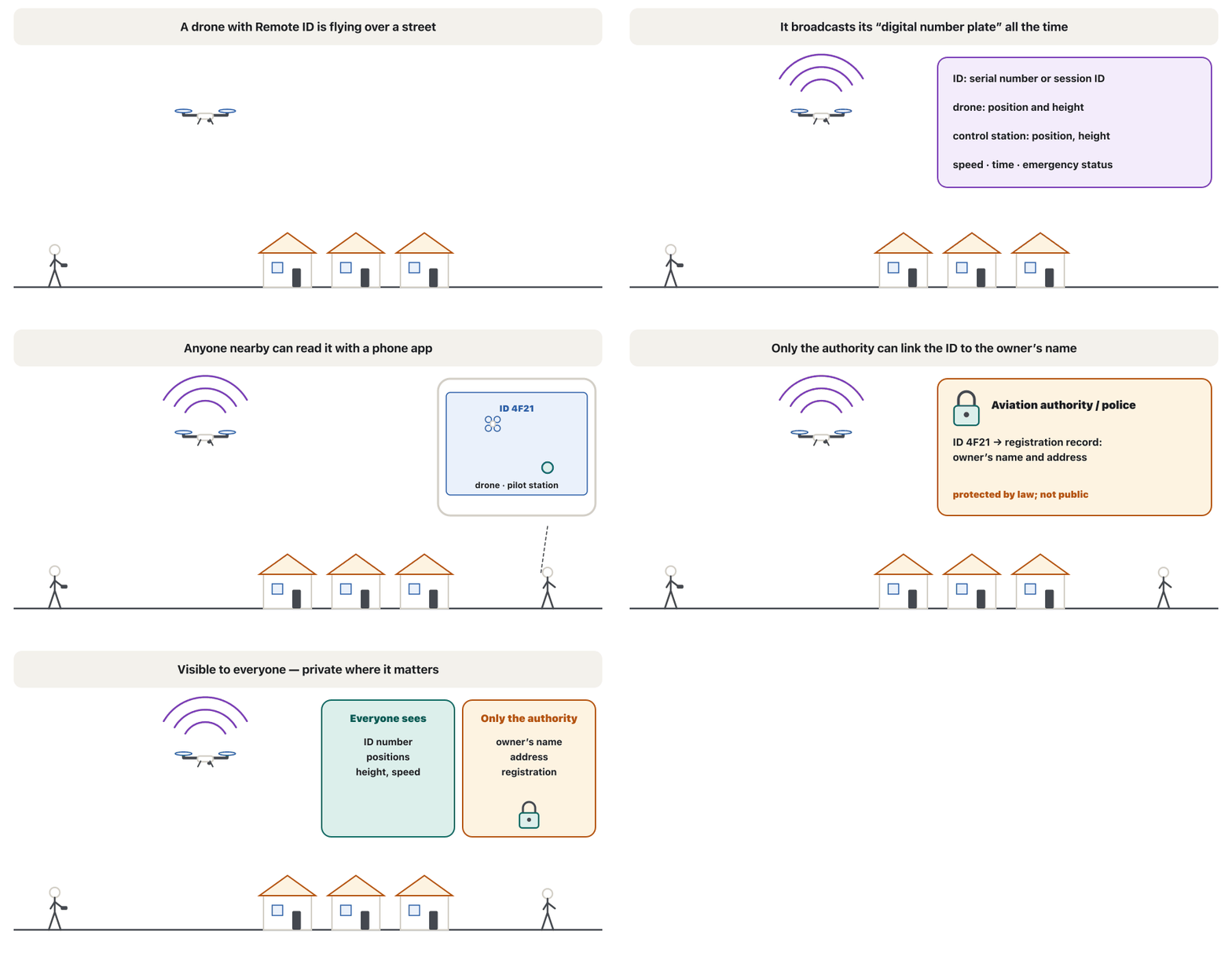
Since March 2024 the FAA has enforced Remote ID, a digital number plate. While it flies, the drone broadcasts its ID (a serial number or a session ID), its position and height, the control station's position and height, its speed, a time mark and an emergency status (14 CFR 89.305).
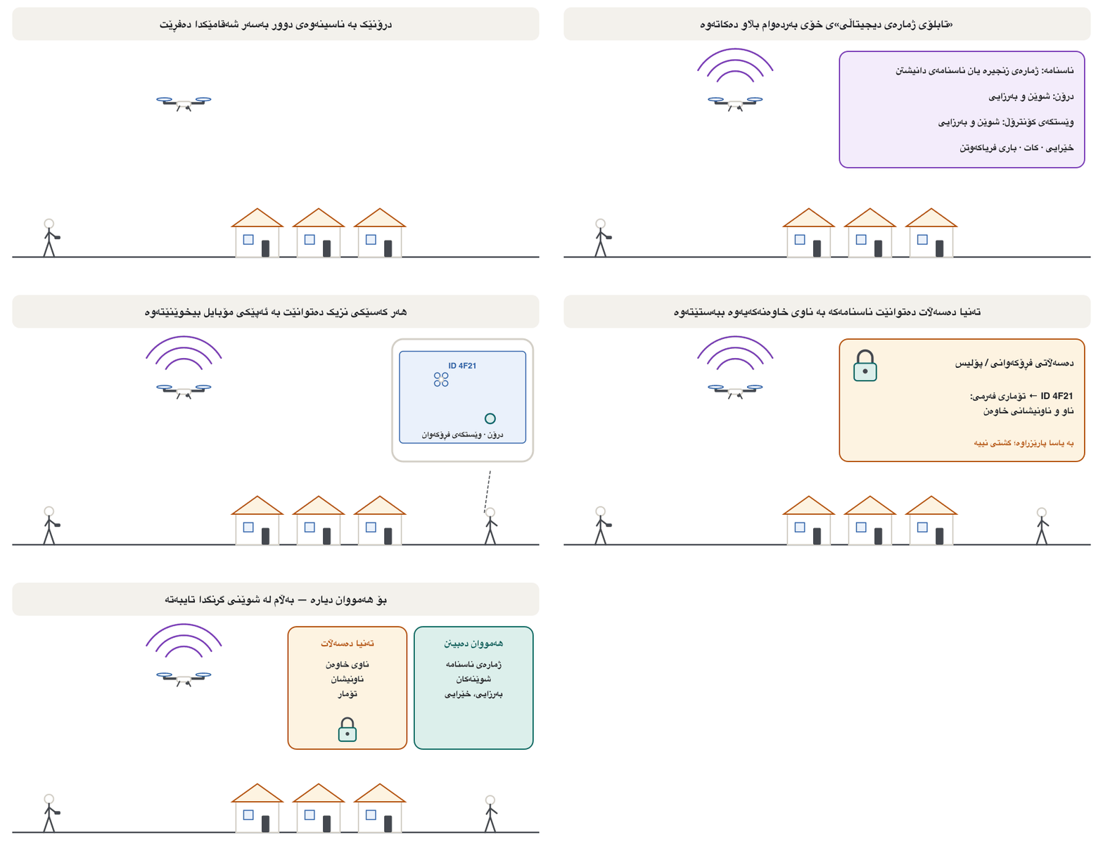
لە ئازاری 2024ـەوە FAA جێبەجێ دەکات، کە وەک تابلۆی ژمارەی دیجیتاڵییە. لە کاتی فڕیندا ناسنامەکەی (ژمارەی زنجیرە یان ناسنامەی دانیشتن)، شوێن و ، شوێن و وێستگەی کۆنترۆڵ، خێراییەکەی، نیشانەیەکی کات و باری فریاکەوتن بڵاو دەکاتەوە (14 CFR 89.305).
There are three ways to comply: a drone built with standard Remote ID; a broadcast module added to an older drone, allowed only while you keep the drone in sight; or flying without Remote ID inside an FAA-recognised identification area (FRIA), such as a model-aircraft field. Anyone nearby can read the broadcast with a phone app, but the owner's name and address are not broadcast — more on privacy in Privacy, security and counter-drone systems.
سێ ڕێگا هەیە بۆ جێبەجێکردن: کە بە ستاندارد دروست کراوە؛ مۆدیولێکی پەخش کە بۆ کۆن زیاد دەکرێت و تەنیا ڕێگەپێدراوە کاتێک لە بەرچاوە؛ یان فڕین بەبێ لە ناو ناوچەیەکی ناسینەوەی پەسەندکراوی FAA (FRIA)، وەک مەیدانێکی فڕۆکەی مۆدێل. هەر کەسێکی نزیک دەتوانێت بە ئەپێکی مۆبایل پەخشەکە بخوێنێتەوە، بەڵام ناو و ناونیشانی خاوەنەکە پەخش ناکرێن — زیاتر لەبارەی لە تایبەتێتی، ئاسایش و سیستەمی دژەدرۆن.
The USA (1): hobby flyers and Part 107ئەمریکا (1): فڕۆکەوانانی خولیایی و Part 107
The USA (3): BVLOS and the Part 108 ruleئەمریکا (3): دەرەوەی هێڵی بینین و یاسای Part 108
Part 107 assumes the drone stays in sight. Today a US company that wants to fly BVLOS — for deliveries or long inspections — needs a waiver or an exemption from the FAA for its own operation.
Part 107 وا دادەنێت کە لە بەرچاو دەمێنێتەوە. ئەمڕۆ کۆمپانیایەکی ئەمریکی کە دەیەوێت بفڕێنێت — بۆ گەیاندن یان پشکنینی درێژ — پێویستی بە ڕێگەپێدانی تایبەت (waiver) یان بەخشینێک (exemption) لە FAA هەیە بۆ کارەکەی خۆی.
To make such flights routine, the FAA proposed a new rule, Part 108, on 7 August 2025. The final rule went to White House review on 10 July 2026 and, as of 4 November 2026, had still not been published. Check the FAA's own pages for the current status before you rely on it.
بۆ ئەوەی ئەو فڕینانە ببنە کارێکی ئاسایی، FAA لە 7ی ئابی 2025 یاسایەکی نوێی پێشنیار کرد، Part 108. یاسا کۆتاییەکە لە 10ی تەممووزی 2026 نێردرا بۆ پێداچوونەوەی کۆشکی سپی و تا 4ی تشرینی دووەمی 2026 هێشتا بڵاو نەکرابووەوە. پێش ئەوەی پشتی پێ ببەستیت، دۆخی ئێستای لە پەڕەکانی خودی FAA بپشکنە.
Europe (1): three categories by riskئەورووپا (1): سێ جۆر بەپێی مەترسی
Since 31 December 2020 the EU has one set of drone rules for all its member states (Regulation 2019/947), applied by EASA and the national authorities. Instead of hobby versus commercial, it sorts flights by risk into three categories:
لە 31ی کانوونی یەکەمی 2020ـەوە یەکێتیی ئەورووپا یەک کۆمەڵە یاسای بۆ هەموو وڵاتە ئەندامەکانی هەیە (ڕێسای 2019/947)، کە EASA و دەسەڵاتە نیشتیمانییەکان جێبەجێی دەکەن. لە جیاتی خولیایی بەرامبەر بازرگانی، فڕینەکان بەپێی دەکاتە سێ جۆر:
- The open category: low risk; no permission, but strict limits.
- The specific category: medium risk; an authorisation based on a risk assessment, or a declared standard scenario.
- The certified category: high risk, treated almost like airlines: a certified drone, a certified operator and a licensed pilot.
- : کەم؛ مۆڵەت ناوێت، بەڵام سنووری توندی هەیە.
- : مامناوەند؛ ڕێگەپێدان لەسەر بنەمای ، یان سیناریۆیەکی ستانداردی ڕاگەیەندراو.
- : بەرز، نزیکەی وەک کۆمپانیای فڕین مامەڵەی لەگەڵ دەکرێت: بڕوانامەدار، کەسی بەرپرسیاری بڕوانامەدار و فڕۆکەوانی مۆڵەتدار.
So a farmer filming his field for work and a teenager filming for fun follow the same open-category rules if their flights are the same.
کەواتە جووتیارێک کە بۆ کار وێنەی کێڵگەکەی دەگرێت و هەرزەکارێک کە بۆ خۆشی وێنە دەگرێت هەمان یاساکانی جێبەجێ دەکەن ئەگەر فڕینەکانیان وەک یەک بن.
Europe (1): three categories by riskئەورووپا (1): سێ جۆر بەپێی مەترسی
Europe (2): the open categoryئەورووپا (2): جۆری کراوە
The open category has firm limits: drones under 25 kg, below 120 m, always in VLOS (FPV only with an observer beside you), no dangerous goods and nothing dropped. Three subcategories say how close you may fly to people:
سنووری توندی هەیە: خوار 25 کیلۆگرام، خوار 120 مەتر، هەمیشە بە (FPV تەنیا بە لە تەنیشتتەوە)، هیچ کاڵایەکی مەترسیدار و هیچ فڕێدانێک. سێ بەشی لاوەکی دەڵێن چەند نزیک لە خەڵک دەتوانیت بفڕیت:
- A1 — over people but never over crowds: C0, C1 or under 250 g.
- A2 — close to people: at least 30 m away, or 5 m in low-speed mode; C2, under 4 kg.
- A3 — far from people: 150 m from people and built-up areas; C3, C4, under 25 kg.
- A1 — بەسەر خەڵکدا بەڵام هەرگیز بەسەر قەرەباڵغیدا نا: C0، C1 یان خوار 250 گرام.
- A2 — نزیک لە خەڵک: لانیکەم 30 مەتر دوور، یان 5 مەتر لە دۆخی خێرایی نزمدا؛ C2، خوار 4 کیلۆگرام.
- A3 — دوور لە خەڵک: 150 مەتر لە خەڵک و ناوچەی نیشتەجێبوون؛ C3، C4، خوار 25 کیلۆگرام.
The minimum age is 16 (a country may lower it to 12). Operators register if the drone is C1 or heavier, weighs 250 g or more, or has a camera and is not a toy; pilots of C1 and heavier drones take the online A1/A3 course and exam, and A2 adds a second exam.
کەمترین تەمەن 16 ساڵە (وڵاتێک دەتوانێت دایبەزێنێت بۆ 12). کەسی بەرپرسیار خۆی تۆمار دەکات ئەگەر C1 یان قورستر بێت، 250 گرام یان زیاتر بێت، یان کامێرای هەبێت و یاری نەبێت؛ فڕۆکەوانانی C1 و قورستر خول و تاقیکردنەوەی ئۆنلاینی A1/A3 دەبڕن و A2 تاقیکردنەوەیەکی دووەم زیاد دەکات.
Europe (1): three categories by riskئەورووپا (1): سێ جۆر بەپێی مەترسی
Class marks: C0 to C6نیشانەکانی پۆل: C0 تا C6
New drones sold in the EU carry a class mark that tells you where they may fly: C0 under 250 g → A1; C1 under 900 g → A1, with Remote ID and geo-awareness; C2 under 4 kg → A2, with a low-speed mode of 3 m/s; C3 and C4 under 25 kg → A3 (C4 for simple models without automatic flight). C5 and C6 are for the standard scenarios STS-01 and STS-02 in the specific category.
نوێیەکان کە لە یەکێتیی ئەورووپا دەفرۆشرێن لەسەرە کە پێت دەڵێت لە کوێ دەتوانن بفڕن: C0 خوار 250 گرام ← A1؛ C1 خوار 900 گرام ← A1، بە و ئاگاداریی ناوچە؛ C2 خوار 4 کیلۆگرام ← A2، بە دۆخی خێرایی نزمی 3 m/s؛ C3 و C4 خوار 25 کیلۆگرام ← A3 (C4 بۆ مۆدێلی سادە بەبێ فڕینی خۆکار). C5 و C6 بۆ سیناریۆ ستانداردەکانی STS-01 و STS-02ن لە .
Drones placed on the market before 2024 without a class mark may still fly: under 250 g in A1, otherwise in A3. (Drone sizes from tiny to airliner-sized are compared in From palm-sized to airliner-sized.)
ئەو پێش 2024 خراونەتە بازاڕەوە و نییە هێشتا دەتوانن بفڕن: خوار 250 گرام لە A1دا، ئەوانی تر لە A3دا. (قەبارەی ، لە زۆر بچووکەوە تا قەبارەی فڕۆکەی ڕێبوار، لە لە قەبارەی لەپی دەستەوە تا قەبارەی فڕۆکەی ڕێبوار بەراورد کراون.)
Europe (1): three categories by riskئەورووپا (1): سێ جۆر بەپێی مەترسی
Europe (3): the specific and certified categoriesئەورووپا (3): جۆری تایبەت و جۆری بڕوانامەدار
A flight that breaks an open-category limit — BVLOS, above 120 m, over 25 kg, dropping things, or a heavier drone in a town — moves to the specific category. There are four ways to get permission: declare a standard scenario (STS-01 or STS-02, with a C5 or C6 drone); follow a predefined risk assessment (PDRA) for a simpler authorisation; do a full SORA risk assessment for an operational authorisation; or, for big operators, hold a light UAS operator certificate (LUC) that lets them approve their own flights. Flying in a geographical zone also needs the zone authority's permission.
فڕینێک کە سنوورێکی دەشکێنێت — ، سەرووی 120 مەتر، سەرووی 25 کیلۆگرام، فڕێدانی شت، یان قورستر لە شارۆچکەیەکدا — دەچێتە . چوار ڕێگا هەیە بۆ وەرگرتنی مۆڵەت: سیناریۆیەکی ستاندارد ڕابگەیەنە (STS-01 یان STS-02، بە C5 یان C6)؛ هەڵسەنگاندنێکی مەترسیی ئامادەکراو (PDRA) جێبەجێ بکە بۆ ڕێگەپێدانێکی سادەتر؛ SORA بکە، واتە تەواو، بۆ ڕێگەپێدانی کارکردن؛ یان بۆ کۆمپانیا گەورەکان، بڕوانامەی LUC هەبێت کە ڕێگەیان دەدات فڕینەکانی خۆیان پەسەند بکەن. فڕین لە مۆڵەتی دەسەڵاتی ئەو ناوچەیەشی پێویستە.
The certified category covers the highest risks — carrying passengers (air taxis), dangerous goods, or big drones over crowds — with type-certified drones, certified operators and licensed pilots, almost like airlines (Air taxis and urban air mobility).
بەرزترین دەگرێتەوە — گواستنەوەی گەشتیار ()، کاڵای مەترسیدار یان گەورەکان بەسەر قەرەباڵغیدا — بە خاوەن ، کەسی بەرپرسیاری بڕوانامەدار و فڕۆکەوانی مۆڵەتدار، نزیکەی وەک کۆمپانیای فڕین (تەکسییە ئاسمانییەکان و گواستنەوەی ئاسمانیی شاری).
The United Kingdom in 2026بەریتانیا لە 2026دا
The UK kept rules close to the EU's, with its own changes from 1 January 2026. You need a Flyer ID (a free online theory test) to fly any drone of 100 g or more, and an Operator ID if the drone weighs 250 g or more, or 100–250 g with a camera. New drones carry UK class marks (UK0 to UK6); EU C-marks are recognised until the end of 2027. Remote ID is required on UK1, UK2 and UK3 drones from 2026 and, from 1 January 2028, on almost every other drone and model aircraft (older drones: from 100 g with a camera). Overseas registrations are not recognised.
بەریتانیا یاسای نزیک لە یەکێتیی ئەورووپای هێشتەوە، لەگەڵ گۆڕانکاریی خۆی لە 1ی کانوونی دووەمی 2026ـەوە. بۆ فڕاندنی هەر 100 گرام یان زیاتر پێویستت بە Flyer ID (تاقیکردنەوەیەکی تیۆریی ئۆنلاینی بێبەرانبەر) هەیە و Operator ID ئەگەر 250 گرام یان زیاتر بێت، یان 100 تا 250 گرام بێت و کامێرای هەبێت. نوێیەکان بەریتانییان لەسەرە (UK0 تا UK6)؛ نیشانەکانی Cـی یەکێتیی ئەورووپا تا کۆتایی 2027 قبووڵ دەکرێن. لەسەر UK1، UK2 و UK3 لە 2026ـەوە پێویستە و لە 1ی کانوونی دووەمی 2028ـەوە لەسەر نزیکەی هەموو و فڕۆکە مۆدێلەکانی تر ( کۆنەکان: لە 100 گرامەوە ئەگەر کامێرایان هەبێت). تۆمارکردنی وڵاتانی تر قبووڵ ناکرێت.
Around protected airports a flight restriction zone applies: a circle of 2 or 2.5 nautical miles plus 1 km-wide zones that reach 5 km out from each runway end, up to 2,000 ft. Inside it you need permission from the airport.
لە دەوری فڕۆکەخانە پارێزراوەکاندا ناوچەیەکی سنووردارکردنی فڕین هەیە: بازنەیەکی 2 یان 2.5 میلی دەریایی لەگەڵ ناوچەی 1 کیلۆمەتر پان کە تا 5 کیلۆمەتر لە هەر کۆتاییەکی ڕێڕەوەوە درێژ دەبنەوە، تا 2,000 پێ. لە ناویدا مۆڵەتی فڕۆکەخانەکەت پێویستە.
Where you may fly: geographical zonesلە کوێ دەتوانیت بفڕیت: ناوچەکانی سنوورداری فڕین
Airspace rules set safe flight zones for drones. Authorities mark geographical zones (geo-zones, no-fly zones) on official maps: airports, prisons, power stations, government and military sites. Some are permanent; some last only a while, such as a stadium on match day or a visit by a head of state.
یاساکانی ناوچەی فڕینی سەلامەت بۆ دیاری دەکەن. دەسەڵاتداران لەسەر نەخشە فەرمییەکان دیاری دەکەن: فڕۆکەخانە، زیندان، وێستگەی کارەبا، شوێنی حکوومی و سەربازی. هەندێکیان هەمیشەیین؛ هەندێکیان تەنیا ماوەیەک دەمێننەوە، وەک یاریگایەک لە ڕۆژی یاریدا یان سەردانی سەرۆکێک.
Temporary limits are announced in NOTAMs (official notices to pilots) and shown in official drone apps; many drones also warn you with built-in geo-awareness, but an app can be out of date — the official map and the authority decide. In the EU, flying in a zone needs the zone authority's permission even in the open category.
سنوورە کاتییەکان لە ڕادەگەیەنرێن (ئاگادارکردنەوەی فەرمی بۆ فڕۆکەوانان) و لە ئەپە فەرمییەکانی پیشان دەدرێن؛ زۆر بە ئاگاداریی ناوچەی ناوخۆیی ئاگادارت دەکاتەوە، بەڵام ئەپ دەکرێت کۆن بێت — نەخشە فەرمییەکە و دەسەڵاتەکە بڕیار دەدەن. لە یەکێتیی ئەورووپادا فڕین لە ناوچەیەکدا، تەنانەت لە ، مۆڵەتی دەسەڵاتی ئەو ناوچەیەی پێویستە.
Where you may fly: geographical zonesلە کوێ دەتوانیت بفڕیت: ناوچەکانی سنوورداری فڕین
UTM and U-space: traffic control for dronesبەڕێوەبردنی هاتوچۆی درۆن و U-space: کۆنترۆڵی هاتوچۆ بۆ درۆنەکان
When many drones share the low sky — deliveries, inspections, police — someone must organise the traffic. UTM (unmanned traffic management) is a set of digital services that does this; ICAO publishes guidance on it. The EU's version, U-space, has applied since January 2023 (Regulation 2021/664).
کاتێک زۆر ئاسمانی نزم بەش دەکەن — گەیاندن، پشکنین، پۆلیس — دەبێت کەسێک هاتوچۆکە ڕێک بخات. کۆمەڵێک خزمەتگوزاریی دیجیتاڵییە کە ئەمە دەکات؛ ڕێنمایی لەسەری بڵاو دەکاتەوە. وەشانەکەی یەکێتیی ئەورووپا، U-space، لە کانوونی دووەمی 2023ـەوە جێبەجێ دەکرێت (ڕێسای 2021/664).
In a U-space airspace, certified U-space service providers must offer four services: flight authorisation for each flight, geo-awareness (the latest zones and limits), network identification (live flight data for every drone) and traffic information about crewed aircraft. Drones may fly there only with these services.
لە U-spaceـدا، دابینکەرە بڕوانامەدارەکانی خزمەتگوزاریی U-space دەبێت چوار خزمەتگوزاری پێشکەش بکەن: ڕێگەپێدانی فڕین بۆ هەر فڕینێک، ئاگاداریی ناوچە (دوایین ناوچە و سنوورەکان)، ناسینەوەی ڕایەڵەیی ( ڕاستەوخۆی فڕینی هەموو ) و زانیاریی هاتوچۆ لەبارەی فڕۆکە فڕۆکەواندارەکان. تەنیا بەم خزمەتگوزارییانە دەتوانن لەوێ بفڕن.
Your country: Iraq and the Kurdistan Regionوڵاتی خۆت: عێراق و هەرێمی کوردستان
What about Iraq and the Kurdistan Region? This is what was published as of November 2026 — always check again before you fly. The Iraqi Civil Aviation Authority (ICAA) publishes its drone rules on its website: the regulation ICAR 124/2025 and the guide CAP 58 "Unmanned Aircraft System (Drones)" (December 2025, corrected January 2026), written for the whole State of Iraq. Among other things, CAP 58 says:
لەبارەی عێراق و هەرێمی کوردستان چی؟ ئەمە ئەوەیە کە تا تشرینی دووەمی 2026 بڵاو کراوەتەوە — پێش فڕین هەمیشە دووپاتە بیپشکنەوە. عێراق (ICAA) یاساکانی لە ماڵپەڕەکەیدا بڵاو دەکاتەوە: ڕێسای ICAR 124/2025 و ڕێنمایی CAP 58 « ()» (کانوونی یەکەمی 2025، ڕاستکراوەی کانوونی دووەمی 2026)، کە بۆ هەموو دەوڵەتی عێراق نووسراوە. CAP 58 لە نێوان شتەکانی تردا دەڵێت:
- Register the drone with the ICAA's Flight Safety Department before flying; toys under 250 g without special sensors are exempt from the permit, not from the rules.
- Remote pilots need a remote pilot certificate issued or accepted by the ICAA.
- Fly only in VLOS, no higher than 400 ft (122 m), by day, away from people, and not over populated areas without permission.
- No flight within 8 km of a controlled airport, such as Erbil International, without the ICAA's prior approval; never over military sites.
- Taking photos or video from a drone needs the ICAA's permission.
- پێش فڕین لای بەشی سەلامەتیی فڕینی ICAA تۆمار بکە؛ یارییەکانی خوار 250 گرام بێ تایبەت لە مۆڵەت بەخشراون، نەک لە یاساکان.
- پێویستی بە هەیە کە ICAA دەری کردبێت یان پەسەندی کردبێت.
- تەنیا بە بفڕە، لە 400 پێ (122 مەتر) بەرزتر نا، بە ڕۆژ، دوور لە خەڵک و بەبێ مۆڵەت بەسەر ناوچەی نیشتەجێبووندا نا.
- هیچ فڕینێک لە ناو 8 کیلۆمەتری فڕۆکەخانەیەکی کۆنترۆڵکراو، وەک فڕۆکەخانەی نێودەوڵەتیی هەولێر، بەبێ ڕەزامەندیی پێشوەختی ICAA؛ هەرگیز بەسەر شوێنی سەربازیدا نا.
- گرتنی وێنە یان ڤیدیۆ لە مۆڵەتی ICAAـی پێویستە.
Your country: Iraq and the Kurdistan Regionوڵاتی خۆت: عێراق و هەرێمی کوردستان
Check before you fly — or bring a droneپێش فڕین بپشکنە — یان پێش هێنانی درۆن
Two more facts as of 2026. News reports (Asharq Al-Awsat, 25 June 2026) say civilian drones need prior approval from the ICAA and the security agencies, and that Iraq's courts were told to apply the anti-terrorism law to anyone who uses drones for unlawful purposes. CêIT found no separate drone rules published by the Kurdistan Regional Government (checked November 2026), so in the Kurdistan Region ask the local authorities too.
دوو ڕاستیی تر تا 2026. هەواڵەکان (ئەلشەرق ئەلئەوسەت، 25ی حوزەیرانی 2026) دەڵێن مەدەنییەکان پێویستیان بە ڕەزامەندیی پێشوەختی ICAA و دەزگا ئەمنییەکان هەیە و بە دادگاکانی عێراق گوتراوە یاسای دژە تیرۆر لەسەر هەر کەسێک جێبەجێ بکەن کە بۆ مەبەستی نایاسایی بەکار دەهێنێت. CêIT هیچ یاسایەکی جیای نەدۆزییەوە کە حکوومەتی هەرێمی کوردستان بڵاوی کردبێتەوە (پشکنراو لە تشرینی دووەمی 2026)، بۆیە لە هەرێمی کوردستان پرسیار لە دەسەڵاتە ناوخۆییەکانیش بکە.
Common mistakesهەڵە باوەکان
| Mistakeهەڵە | Betterباشتر |
|---|---|
| "Drone rules are the same everywhere."«یاساکانی لە هەموو شوێنێک وەک یەکن.» | Each country has its own law; even the registration weight differs (250 g in the USA, 100 g for the UK Flyer ID). Check the country you fly in.هەر وڵاتێک یاسای خۆی هەیە؛ تەنانەت کێشی تۆمارکردنیش جیاوازە (250 گرام لە ئەمریکا، 100 گرام بۆ Flyer IDـی بەریتانیا). یاسای ئەو وڵاتە بپشکنە کە تێیدا دەفڕیت. |
| "Under 250 g means no rules."«خوار 250 گرام واتە بێ یاسا.» | Light drones still follow the flying rules. In the USA, flying for work always needs Part 107; in the UK a Flyer ID starts at 100 g. سووکەکانیش یاساکانی فڕین جێبەجێ دەکەن. لە ئەمریکا فڕاندن بۆ کار هەمیشە Part 107ـی پێویستە؛ لە بەریتانیا Flyer ID لە 100 گرامەوە دەست پێ دەکات. |
| "Only paid work needs rules; hobby flying is free."«تەنیا کاری بە پارە یاسای پێویستە؛ فڕاندنی خولیایی ئازادە.» | In the EU the risk decides, not money; in Iraq CAP 58 applies to everyone.لە یەکێتیی ئەورووپا بڕیار دەدات، نەک پارە؛ لە عێراق CAP 58 لەسەر هەمووان جێبەجێ دەبێت. |
| "The app showed no warning, so the place is allowed."«ئەپەکە هیچ ئاگادارکردنەوەیەکی نیشان نەدا، کەواتە شوێنەکە ڕێگەپێدراوە.» | Apps can be out of date. The official map, today's NOTAMs and the authority decide.ئەپ دەکرێت کۆن بێت. نەخشە فەرمییەکە، ئەمڕۆ و دەسەڵاتەکە بڕیار دەدەن. |
| "ICAO's model rules are the law everywhere."«یاسا نموونەییەکانی لە هەموو شوێنێک یاسان.» | They are a template; each country's own law applies.قاڵبن؛ یاسای خودی هەر وڵاتێک جێبەجێ دەبێت. |
| "Part 108 already allows BVLOS in the USA."«Part 108 لە ئێستاوە ڕێگە بە دەدات لە ئەمریکا.» | As of November 2026 it was not final; BVLOS needs a waiver or exemption.تا تشرینی دووەمی 2026 کۆتایی نەهاتبوو؛ ڕێگەپێدانی تایبەت یان بەخشینی پێویستە. |
| "My certificate from home is valid everywhere."«بڕوانامەکەی وڵاتی خۆم لە هەموو شوێنێک کار دەکات.» | The UK does not recognise overseas registrations, and Iraq asks for a certificate issued or accepted by the ICAA.بەریتانیا تۆمارکردنی وڵاتانی تر قبووڵ ناکات و عێراق بڕوانامەیەک داوا دەکات کە ICAA دەری کردبێت یان پەسەندی کردبێت. |
Exercisesڕاهێنانەکان
Make a table with four rows — the USA, the EU, the UK and Iraq — and four columns: when you must register, what the pilot needs, the height limit, and what is said about airports. Use this lesson and add the date you checked.
خشتەیەک دروست بکە بە چوار ڕیز — ئەمریکا، یەکێتیی ئەورووپا، بەریتانیا و عێراق — و چوار ستوون: کەی دەبێت تۆمار بکەیت، فڕۆکەوان چی پێویستە، سنووری و چی لەبارەی فڕۆکەخانە گوتراوە. ئەم وانەیە بەکار بهێنە و ئەو ڕێکەوتەش زیاد بکە کە پشکنیوتە.
Hintئاماژە
Look again at the USA, Europe, UK and Iraq screens.
دووپاتە سەیری پەڕەکانی ئەمریکا، ئەورووپا، بەریتانیا و عێراق بکەرەوە.
Show answerوەڵامەکە پیشان بدە
| Placeشوێن | Registerتۆمارکردن | Pilotفڕۆکەوان | Height | Airportsفڕۆکەخانە |
|---|---|---|---|---|
| USAئەمریکا | Recreational: over 250 g; Part 107: every droneخولیایی: سەرووی 250 گرام؛ Part 107: هەموو | TRUST, or a remote pilot certificate (16+)TRUST، یان (16+) | 400 ft400 پێ | Authorisation in controlled airspace (LAANC)ڕێگەپێدان لە کۆنترۆڵکراودا (LAANC) |
| EUیەکێتیی ئەورووپا | The operator: C1 and up, 250 g and up, or a camera (not a toy)کەسی بەرپرسیار: C1 و سەرووتر، 250 گرام و سەرووتر، یان کامێرا (نەک یاری) | Online A1/A3 exam; A2 extra exam (16+)تاقیکردنەوەی ئۆنلاینی A1/A3؛ تاقیکردنەوەی زیاتری A2 (16+) | 120 m120 مەتر | Geographical zones need the zone authority's permission مۆڵەتی دەسەڵاتی ناوچەکەیان پێویستە |
| UKبەریتانیا | Operator ID: 250 g and up, or 100–250 g with a cameraOperator ID: 250 گرام و سەرووتر، یان 100 تا 250 گرام بە کامێرا | Flyer ID from 100 gFlyer ID لە 100 گرامەوە | 120 m120 مەتر | Flight restriction zones: airport permissionناوچەی سنووردارکردنی فڕین: مۆڵەتی فڕۆکەخانە |
| Iraqعێراق | With the ICAA before flying (toys under 250 g exempt from the permit)لای ICAA پێش فڕین (یارییەکانی خوار 250 گرام لە مۆڵەت بەخشراون) | ICAA remote pilot certificate ICAA | 400 ft (122 m), by day400 پێ (122 مەتر)، بە ڕۆژ | 8 km of a controlled airport: prior ICAA approval8 کیلۆمەتری فڕۆکەخانەی کۆنترۆڵکراو: ڕەزامەندیی پێشوەختی ICAA |
Name the EU category (and subcategory where possible): (a) a 249 g C0 drone filming a family picnic; (b) a C2 drone inspecting a roof in a town, 10 m from passers-by, in low-speed mode; (c) a 30 kg spraying drone over a farm; (d) a BVLOS pipeline inspection; (e) a passenger air taxi.
جۆری یەکێتیی ئەورووپا (و بەشی لاوەکی ئەگەر دەکرێت) ناو ببە: (a) C0ـی 249 گرامی کە وێنەی سەیرانێکی خێزانی دەگرێت؛ (b) C2 کە سەربانێک لە شارۆچکەیەکدا دەپشکنێت، 10 مەتر لە ڕێبوارانەوە، لە دۆخی خێرایی نزمدا؛ (c) 30 کیلۆگرامی بەسەر کێڵگەیەکدا؛ (d) پشکنینی بۆرییەک بە ؛ (e) کە گەشتیار دەگوازێتەوە.
Show answerوەڵامەکە پیشان بدە
- (a) Open, A1.
- (b) Open, A2: more than 5 m away in low-speed mode, never over them.
- (c) Specific: it is over 25 kg (spraying has its own national rules too).
- (d) Specific: a standard scenario (STS-02, with airspace observers) or an authorisation.
- (e) Certified.
- (a) ، A1.
- (b) ، A2: لە دۆخی خێرایی نزمدا زیاتر لە 5 مەتر دوور، هەرگیز بەسەریاندا نا.
- (c) : لە 25 کیلۆگرام قورسترە (پرژاندنیش یاسای نیشتیمانیی خۆی هەیە).
- (d) : سیناریۆیەکی ستاندارد (STS-02، بە چاودێرانی ئاسمان) یان ڕێگەپێدان.
- (e) .
Aram wants drone shots of the Erbil Citadel for a school project. Using the Erbil map and CAP 58, list what stands in his way and suggest two legal options.
ئارام دەیەوێت بۆ پرۆژەیەکی قوتابخانە وێنەی قەڵای هەولێر بە بگرێت. بە بەکارهێنانی نەخشەی هەولێر و CAP 58، ئەو شتانە بنووسە کە ڕێگرن و دوو ڕێگای یاسایی پێشنیار بکە.
Hintئاماژە
Distance to the airport, people around the Citadel, filming permission, security.
دووری لە فڕۆکەخانە، خەڵکی دەوری قەڵا، مۆڵەتی وێنەگرتن، ئاسایش.
Show answerوەڵامەکە پیشان بدە
The Citadel is about 6.6 km from Erbil International Airport, inside the 8 km ring, so the ICAA's prior approval is needed; the city centre is populated and crowded; filming from a drone needs permission; and news reports say the security agencies must approve too. Legal options: apply to the ICAA (and the local authorities) well in advance and fly only with written permission, or use existing licensed photos and film from the ground instead.
قەڵا نزیکەی 6.6 کیلۆمەتر لە فڕۆکەخانەی نێودەوڵەتیی هەولێرەوە دوورە، لە ناو ئەڵقە 8 کیلۆمەترییەکەدا، بۆیە ڕەزامەندیی پێشوەختی ICAA پێویستە؛ ناوەندی شار نیشتەجێبووە و قەرەباڵغە؛ وێنەگرتن لە مۆڵەتی پێویستە؛ هەواڵەکانیش دەڵێن دەزگا ئەمنییەکانیش دەبێت ڕەزامەندی بدەن. ڕێگا یاساییەکان: زۆر پێشتر داوا لە ICAA (و دەسەڵاتە ناوخۆییەکان) بکە و تەنیا بە مۆڵەتی نووسراو بفڕێنە، یان وێنەی مۆڵەتداری ئامادە بەکار بهێنە و لەسەر زەوییەوە وێنە بگرە.
Summaryپوختە
- Drone rules are risk-based: weight, place and people decide how strict they are.
- Almost every country asks you to register above a weight, stay low (about 120 m / 400 ft), keep away from airports and stay away from people.
- ICAO writes standards and model regulations; each country's civil aviation authority makes and enforces its own law.
- USA: TRUST for hobby flyers, Part 107 and a remote pilot certificate for work, Remote ID, BVLOS by waiver (Part 108 not final in November 2026).
- EU: open (A1/A2/A3, class marks C0–C4), specific (STS, PDRA, SORA, LUC) and certified categories; UK: Flyer ID from 100 g since 2026.
- Geographical zones, NOTAMs and UTM/U-space tell you where and when you may fly.
- Iraq: ICAR 124 and CAP 58 (ICAA) — registration, a certificate, VLOS, 400 ft, by day, 8 km around controlled airports, permission to film; ask the authorities before you fly or bring a drone.
- یاساکانی لەسەر بنەمای : کێش، شوێن و خەڵک دیاری دەکەن چەند توندن.
- نزیکەی هەموو وڵاتێک داوات لێ دەکات لە سەرووی کێشێکەوە تۆمار بکەیت، نزم بمێنیتەوە (نزیکەی 120 مەتر / 400 پێ)، لە فڕۆکەخانە و لە خەڵک دوور بیت.
- ستاندارد و یاسای نموونەیی دەنووسێت؛ هەر وڵاتێک یاسای خۆی دادەنێت و جێبەجێی دەکات.
- ئەمریکا: TRUST بۆ خولیاییەکان، Part 107 و بۆ کار، ، بە ڕێگەپێدانی تایبەت (Part 108 لە تشرینی دووەمی 2026دا کۆتایی نەهاتبوو).
- یەکێتیی ئەورووپا: (A1/A2/A3، C0 تا C4)، (STS، PDRA، SORA، LUC) و ؛ بەریتانیا: Flyer ID لە 100 گرامەوە لە 2026ـەوە.
- ، و /U-space پێت دەڵێن لە کوێ و کەی دەتوانیت بفڕیت.
- عێراق: ICAR 124 و CAP 58 (ICAA) — تۆمارکردن، بڕوانامە، ، 400 پێ، بە ڕۆژ، 8 کیلۆمەتر بە دەوری فڕۆکەخانە کۆنترۆڵکراوەکاندا، مۆڵەتی وێنەگرتن؛ پێش فڕین یان هێنانی پرسیار لە دەسەڵاتداران بکە.
What three questions decide a drone flight's risk?چ سێ پرسیارێک مەترسیی فڕینێکی درۆن دیاری دەکەن؟
How heavy is the drone, where does it fly, and over whom?
چەند قورسە، لە کوێ دەفڕێت و بەسەر کێدا؟
What is the difference between the EU's open and specific categories?جیاوازیی نێوان جۆری کراوە و جۆری تایبەتی یەکێتیی ئەورووپا چییە؟
Open is low risk with fixed limits and no permission; specific is medium risk and needs an authorisation (or a declared standard scenario).
کەمە بە سنووری جێگیر و بێ مۆڵەت؛ مامناوەندە و ڕێگەپێدان پێویستە (یان سیناریۆیەکی ستانداردی ڕاگەیەندراو).
Where do you find the official drone rules for Iraq?یاسا فەرمییەکانی درۆن بۆ عێراق لە کوێ دەدۆزیتەوە؟
On the Iraqi Civil Aviation Authority's Drones page (ICAR 124 and CAP 58) — and by asking the ICAA and, in the Kurdistan Region, the local authorities.
لە پەڕەی «Drones»ی عێراق (ICAR 124 و CAP 58) — هەروەها بە پرسیارکردن لە ICAA و لە هەرێمی کوردستان لە دەسەڵاتە ناوخۆییەکان.
Lesson complete!وانەکە تەواو بوو!
Well done. Review the key terms, then go on to the next lesson.دەستخۆش. سەیرێکی زاراوە سەرەکییەکان بکەرەوە، پاشان بڕۆ بۆ وانەی داهاتوو.
Key termsزاراوە سەرەکییەکان
Privacy, Security and Counter-Drone Systemsتایبەتێتی، ئاسایش و تەکنەلۆجیای دژەدرۆن
Related lecturesوانە پەیوەندیدارەکان
- Privacy, Security and Counter-Drone Systemsتایبەتێتی، ئاسایش و تەکنەلۆجیای دژەدرۆن
- What Is a Drone? UAV, UAS, RPAS and a Short Historyدرۆن چییە؟ UAV، UAS، RPAS و مێژوویەکی کورت
- GNSS Navigation, Return-to-Home, Geofences and Failsafesڕێنیشاندەری GNSS، گەڕانەوە بۆ ماڵ، پەرژینەکانی جوگرافی و سەلامەتیی کاتی تێکچوون
- Radio Links: Remote Control, Telemetry, FPV Video and 5Gپەیوەندیی ڕادیۆیی: کۆنترۆڵی دوور، تەلەمەتری، ڤیدیۆی FPV و 5G
- Drones at Work: Farms, Building Sites, Emergencies, Media and Deliveryدرۆنەکان لە کاردا: کێڵگە، شوێنی بیناسازی، فریاکەوتن، میدیا و گەیاندن
- Autonomy, Swarms, Air Taxis and the Future of Dronesسەربەخۆیی، ڕەوەکانی درۆن، تەکسییە ئاسمانییەکان و داهاتووی درۆنەکان
- Emerging Technologies: IoT, VR/AR, Robots and Blockchainتەکنەلۆجیا نوێیەکان: ئینتەرنێتی شتەکان، ڕاستیی گریمانەیی/ڕاستیی زیادکراو، ڕۆبۆتەکان و بلۆکچەین
- Computer-Crime Laws: Budapest, the CFAA, the UK and the Law at Homeیاساکانی تاوانی سایبەری: بوداپێست، CFAA، بەریتانیا و یاسا لە وڵاتی خۆمان
- War Has Rules: International Law and Military AIشەڕیش یاسای هەیە: یاسای نێودەوڵەتی و ژیریی دەستکردی سەربازی
References and further readingسەرچاوەکان و خوێندنەوەی زیاتر
- ICAO: Model UAS Regulations (Parts 101, 102 and 149)
- 14 CFR 48.15 Requirement to register (LII)
- 49 U.S.C. 44809 Exception for limited recreational operations (LII)
- 14 CFR 107.12 Requirement for a remote pilot certificate (LII)
- 14 CFR 107.61 Eligibility (LII)
- 14 CFR 107.51 Operating limitations (LII)
- 14 CFR 91.119 Minimum safe altitudes (LII)
- 14 CFR 89.305 Minimum message elements broadcast by standard remote identification unmanned aircraft (LII)
- 14 CFR 89.115 Alternative remote identification (LII)
- UAS Dashboard: Part 108 guide (NPRM 7 August 2025; OIRA review since 10 July 2026)
- UAShield: Is Part 108 final? (updated 29 October 2026)
- EASA: Open category — civil drones
- EASA: Specific category — civil drones
- EASA FAQ: U-space airspace and its four mandatory services
- AESA (Spain): Remote pilot training in the open category
- UK CAA: Registering to fly drones and model aircraft
- UK CAA: Remote ID
- UK CAA: Aerodromes, heliports and spaceports (flight restriction zones)
- Heliguy: UK drone rules change on 1 January 2026 (31 December 2025)
- Iraq Civil Aviation Authority: Drones (ICAR 124, UAS training, CAP 58)
- ICAA CAP 58: Unmanned Aircraft System (Drones), corrected January 2026 (PDF)
- Asharq Al-Awsat: Iraqi judiciary applies 'terrorism provisions' to drones (25 June 2026)
- Federal Register: documents on 'Normalizing Unmanned Aircraft Systems Beyond Visual Line of Sight Operations' (NPRM 7 Aug 2025, comment period reopened Jan–Feb 2026; no final rule as of 4 Nov 2026)
This lecture is a first edition. The Kurdish text and terminology are waiting for review by Kurdish IT teachers.ئەم وانەیە چاپی یەکەمە. دەقە کوردییەکە و زاراوەکانی چاوەڕێی پێداچوونەوەی مامۆستایانی کوردی بواری IT ن.